List of megalithic monuments in Ireland

Last updated

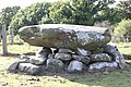
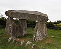
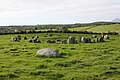
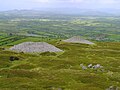
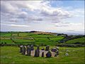
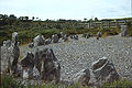
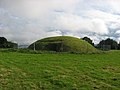
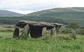
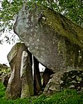
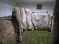
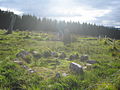
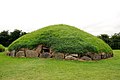
This is a list of megalithic monument on the island of Ireland. Megalithic monuments are found throughout Ireland, and include burial sites (including passage tombs, portal tombs and wedge tombs (or dolmens)) and ceremonial sites (such as stone circles and stone rows).

Contents

PhotographNameCountyCoordinatesTypeAge
Aghanaglack Dual Court - geograph.org.uk - 1453704.jpg Aghanaglack Fermanagh court tomb (double)-
Annadorn (11), October 2009.JPG Annadorn Dolmen Down 54°20′31.75″N5°48′12.52″W / 54.3421528°N 5.8034778°W / 54.3421528; -5.8034778 (Annadorn Dolmen) passage tomb [1] -
Ardgroom SW (v707553).jpg Ardgroom Cork 51°44′23.23″N9°53′37.9″W / 51.7397861°N 9.893861°W / 51.7397861; -9.893861 (Ardgroom) stone circle -
Audleystown Cairn - geograph.org.uk - 243163.jpg Audleystown Court Tomb Down 54°22′29.13″N5°35′58.08″W / 54.3747583°N 5.5994667°W / 54.3747583; -5.5994667 (Audleystown Court Tomb) court tomb -
Auglish.jpg Aughlish Londonderry 54°53′46″N7°02′28″W / 54.896°N 7.041°W / 54.896; -7.041 (Aughlish) stone circles -
- Ballinran Court Tomb Down - court tomb -
- Ballyalton Court Tomb Down 54°19′44″N5°38′47″W / 54.3288°N 5.6463°W / 54.3288; -5.6463 (Ballyalton Court Tomb) court tomb -
- Ballyedmonduff Wedge Tomb Dublin - wedge tomb -
Ballykeel Dolmen.jpg Ballykeel Dolmen Armagh 54°08′12″N6°28′16″W / 54.136696°N 6.471204°W / 54.136696; -6.471204 (Ballykeel Dolmen) portal tomb -
BallylumfordDolmen(DonMcCluney)Jul2007.jpg Ballylumford Dolmen Antrim 54°50′30″N5°46′26″W / 54.84167°N 5.77389°W / 54.84167; -5.77389 (Ballylumford Dolmen) portal tomb 4000 years
Dooey'sCairn(PaulO'Brien)Jun2008.jpg Ballymacaldrack Court Tomb Antrim 55°0′5.9″N6°24′15.3″W / 55.001639°N 6.404250°W / 55.001639; -6.404250 (Ballymacaldrack Court Tomb) court tomb -
Ballynoe (25), September 2009.JPG Ballynoe stone circle Down 54°17′27″N5°43′35″W / 54.290937°N 5.726292°W / 54.290937; -5.726292 (Ballynoe Stone Circle) stone circle -
Co. Tyrone, Beaghmore A Stone Circle and Cairn.jpg Beaghmore Tyrone 54°42′14″N6°56′11″W / 54.70389°N 6.93639°W / 54.70389; -6.93639 (Beaghmore) stone circles, cairns -
- Beenalaght Cork - stone row -
Beltany Stone Circle P1180130.jpg Beltany stone circle Donegal 54°51.025′N7°36.28′W / 54.850417°N 7.60467°W / 54.850417; -7.60467 (Beltany stone circle) stone circle -
Bocan Stone Circle.jpg Bocan Stone Circle Donegal 55°16′20″N7°08′53″W / 55.27222°N 7.14805°W / 55.27222; -7.14805 (Bocan Stone Circle) stone circle -
- Bohonagh Cork 51°34′48″N8°59′56″W / 51.580102°N 8.998987°W / 51.580102; -8.998987 (Bohonagh) stone circle -
IMG BrownshillDolmen.jpg Brownshill Dolmen Carlow - portal tomb 5000–6000 years
- Carnfree Roscommon - cairns, standing stones -
Carrigagulla 03.jpg Carrigagulla Cork - stone circles, stone rows -
CarrowkeelIreland.jpg Carrowkeel Tombs Sligo 54°03′12″N8°22′40″W / 54.05333°N 8.37778°W / 54.05333; -8.37778 (Carrowkeel Tombs) passage tombs 5100–5400 years
Carrowmore.JPG Carrowmore Sligo 54°15′03.08″N8°31′09.00″W / 54.2508556°N 8.5191667°W / 54.2508556; -8.5191667 (Carrowmore) various-
Castlenalacht4.jpg Castlenalacht Stone Row Cork - Stone row -
IMG CastlestrangeStone2771.jpg Castlestrange stone Roscommon - standing stone -
Cloghanmore small.JPG Cloghanmore Donegal - court tomb -
View towards road entrance.JPG Cohaw Cavan - court tomb -
Stone circle, Corick.jpg Corick Londonderry 54°44′53″N6°47′28″W / 54.748°N 6.791°W / 54.748; -6.791 (Corick) stone circles -
County Kerry - Coom Tomb - 20120103160021.jpg Coom Wedge Tomb Kerry 51°49′24.7″N10°18′48.9″W / 51.823528°N 10.313583°W / 51.823528; -10.313583 (Coom) wedge tomb -
- Craigs Dolmen Antrim 55°00′07″N6°28′26″W / 55.00194°N 6.47389°W / 55.00194; -6.47389 (Craigs Dolmen) passage tomb -
View of Dowth.jpg Dowth
(part of Brú na Bóinne)
Meath 53°42′10.5″N6°26′57″W / 53.702917°N 6.44917°W / 53.702917; -6.44917 (Dowth) passage tomb -
DrombegStoneCircle 2004.jpg Drombeg stone circle Cork 51°33′52″N9°05′13″W / 51.564553°N 9.08702°W / 51.564553; -9.08702 (Drombeg stone circle) recumbent stone circle -
Drumskinny Stone Circle and Alignment - geograph.org.uk - 65949.jpg Drumskinny Fermanagh 54°35′04″N7°41′26″W / 54.58443°N 7.69051°W / 54.58443; -7.69051 (Drumskinny) stone circle, cairn -
- Eightercua Kerry 51°48′54″N10°09′29″W / 51.81491°N 10.15807°W / 51.81491; -10.15807 (Eightercua) stone row 3700 years
Greystone011-6may08 006.JPG Faulagh Mayo 54°16′00″N9°47′00″W / 54.26667°N 9.78333°W / 54.26667; -9.78333 (Faulagh) various-
- Gartnanoul Cavan - court tomb -
Northern Ireland Belfast Giants Ring 001.jpg Giant's Ring Down 54°32′25″N5°57′0″W / 54.54028°N 5.95000°W / 54.54028; -5.95000 (Giant's Ring) passage tomb [2] -
Glantane East Wedge Tomb.jpg Glantane East Cork 52°00′16″N9°02′41″W / 52.004426°N 9.04485°W / 52.004426; -9.04485 (Glantane East) various-
Goward Dolmen.jpg Goward Dolmen Down 54°12′53″N6°05′29″W / 54.21464°N 6.09132°W / 54.21464; -6.09132 (Goward Dolmen) portal tomb -
Grange stone circle.jpg Grange stone circle Limerick 52°30′51.45″N8°32′30.45″W / 52.5142917°N 8.5417917°W / 52.5142917; -8.5417917 (Grange stone circle) stone circle -
Kealkill Stone Circle (geograph 3325717).jpg Kealkill stone circle Cork 51°44′43″N9°22′15″W / 51.7452°N 9.3707°W / 51.7452; -9.3707 (Kealkill stone circle) stone circle -
Kilclooney More Portal Tomb Dg. 70 North-Eastern Chamber SE II 2016 08 30.jpg Kilclooney More Donegal 54°49′04″N8°25′59″W / 54.817718°N 8.4331537°W / 54.817718; -8.4331537 two portal tombs, one court tomb
Kilmashogue Megalithic Site 4.JPG Kilmashogue Dublin - wedge tomb, portal tombs, standing stones -
Kilmogue Dolmen 2010.jpg Kilmogue Kilkenny 52°24′11″N7°15′44″W / 52.403143°N 7.262261°W / 52.403143; -7.262261 (Kilmogue) portal tomb
Queen Anya's Tomb - geograph.org.uk - 150185.jpg Knockmany Passage Tomb Tyrone 54°26′51″N7°9′34″W / 54.44750°N 7.15944°W / 54.44750; -7.15944 (Knockmany) passage tomb
Knockmaroon Tomb 01.jpg Knockmaree Dolmen Dublin 53°21′4″N6°20′30″W / 53.35111°N 6.34167°W / 53.35111; -6.34167 (Knockmaree) cist
Knocknakilla 0535.jpg Knocknakilla Cork 52°00′24″N9°01′28″W / 52.00680°N 9.02448°W / 52.00680; -9.02448 (Knocknakilla) stone circle, standing stone
County Kilkenny - Knockroe Passage Tomb - 20190909104959.jpg Knockroe Passage Tomb Kilkenny 52°25′54″N7°23′59″W / 52.43167°N 7.39972°W / 52.43167; -7.39972 (Knockroe) passage tomb
Sligo medb.jpg Knocknarea Sligo 54°15′32″N8°34′29″W / 54.25891°N 8.57463°W / 54.25891; -8.57463 (Knocknarea) various-
Knowth02.jpg Knowth
(part of Brú na Bóinne)
Meath 53°42′06″N6°29′30″W / 53.70167°N 6.49167°W / 53.70167; -6.49167 (Knowth) passage tomb -
11. Labbacallee Wedge Tomb, Co. Cork.jpg Labbacallee Cork 52°10′11″N8°20′13″W / 52.16983°N 8.33688°W / 52.16983; -8.33688 (Labbacallee) wedge tomb -
Legananny Dolmen (16), December 2009.JPG Legananny Dolmen Down 54°19′23″N6°01′12″W / 54.323°N 6.020°W / 54.323; -6.020 (Legannany Dolmen) portal tomb -
Tara stone.jpg Lia Fáil Meath 53°34′39″N6°36′43″W / 53.57750°N 6.61194°W / 53.57750; -6.61194 (Lia Fáil) standing stone -
Lisnadarragh Wedge Tomb.jpg Lisnadarragh Wedge Tomb Monaghan 54°0′48″N6°53′44″W / 54.01333°N 6.89556°W / 54.01333; -6.89556 (Lisnadarragh) wedge tomb -
Central Chamber.jpg Listoghil
(part of Carrowmore)
Sligo --5380–5640 years
Cairn T Loughcrew.jpg Loughcrew Cairns Meath 53°46′10″N7°6′11″W / 53.76944°N 7.10306°W / 53.76944; -7.10306 (Loughcrew Cairns) cairns 5300–5500 years
- Magh Slécht Cavan -various-
IMG Meehambee2820.jpg Meehambee Dolmen Roscommon - portal tomb 5500 years
- Moylehid Fermanagh - passage tomb, cairn -
Newgrange Entrance.jpg Newgrange or Sí an Bhrú
(part of Brú na Bóinne)
Meath 53°41′39.73″N6°28′30.11″W / 53.6943694°N 6.4750306°W / 53.6943694; -6.4750306 (Newgrange) passage tomb 5000 years
Paulnabrone.jpg Poulnabrone dolmen Clare 53°2′55.83″N9°8′23.83″W / 53.0488417°N 9.1399528°W / 53.0488417; -9.1399528 (Poulnabrone dolmen) portal tomb -
Slidderyford Dolmen, May 2011 (03).JPG Slidderyford Dolmen Down - portal tomb -
- Tallowroe Galway - standing stone -
Templebryan 1.jpg Templebryan Stone Circle Cork 51°38′35″N8°53′00″W / 51.64316°N 8.88335°W / 51.64316; -8.88335 (Templebryan Stone Circle) stone circle -
Tibradden Passage Grave.jpg Tibradden Dublin 53°14′20.15″N6°16′52.74″W / 53.2389306°N 6.2813167°W / 53.2389306; -6.2813167 (Tibradden) passage tomb -
Passage tomb, Townleyhall, Co. Louth - geograph.org.uk - 1078235.jpg Townleyhall
(part of Brú na Bóinne)
Louth - passage tomb -
Stone of Turoe.JPG Turoe stone Galway 53°15′N8°33′W / 53.250°N 8.550°W / 53.250; -8.550 (Turoe stone) standing stone -
Uragh Stone Circle.jpg Uragh Stone Circle Kerry 51°48′42.23″N9°41′37.74″W / 51.8117306°N 9.6938167°W / 51.8117306; -9.6938167 (Uragh Stone Circle) stone circle -

See also

Map all coordinates using: OpenStreetMap

Related Research Articles

<span class="mw-page-title-main">Maeshowe</span> Neolithic chambered cairn and passage grave situated on Mainland Orkney, Scotland

Maeshowe is a Neolithic chambered cairn and passage grave situated on Mainland Orkney, Scotland. It was probably built around 2800 BC. In the archaeology of Scotland, it gives its name to the Maeshowe type of chambered cairn, which is limited to Orkney.

<span class="mw-page-title-main">Ring of Brodgar</span> A neolithic stone circle in Orkney, Scotland

The Ring of Brodgar is a Neolithic henge and stone circle about 6 miles north-east of Stromness on Mainland, the largest island in Orkney, Scotland. It is part of the UNESCO World Heritage Site known as the Heart of Neolithic Orkney.

<span class="mw-page-title-main">Megalith</span> Large stone used to build a structure or monument

A megalith is a large stone that has been used to construct a prehistoric structure or monument, either alone or together with other stones. There are over 35,000 in Europe alone, located widely from Sweden to the Mediterranean sea.

<span class="mw-page-title-main">Court cairn</span> Type of chamber tomb found in Ireland and Scotland

The court cairn or court tomb is a megalithic type of chambered cairn or gallery grave. During the period, 3900–3500 BC, more than 390 court cairns were built in Ireland and over 100 in southwest Scotland. The Neolithic monuments are identified by an uncovered courtyard connected to one or more roofed and partitioned burial chambers. Many monuments were built in multiple phases in both Ireland and Scotland and later re-used in the Early Bronze Age.

<span class="mw-page-title-main">Corick</span>

<span class="mw-page-title-main">Beaghmore</span> Early Bronze Age complex in Northern Ireland

Beaghmore is a complex of early Bronze Age megalithic features, stone circles and cairns, 8.5 miles north west of Cookstown, County Tyrone in Northern Ireland, on the south-east edge of the Sperrin Mountains.

<span class="mw-page-title-main">Giant's Ring</span> Neolithic henge monument

The Giant's Ring is a henge monument at Ballynahatty, near Shaw's Bridge, Belfast, Northern Ireland. It was originally preserved by Viscount Dungannon. The inscribed stone tablet on the wall surrounding the site which details Viscount Dungannon's interest was carved by Belfast stonecarver Charles A Thompson about c.1919.

<span class="mw-page-title-main">Carrowmore</span> Megalithic cemetery in County Sligo, Ireland

Carrowmore is a large group of megalithic monuments on the Coolera Peninsula to the west of Sligo, Ireland. They were built in the 4th millennium BC, during the Neolithic. There are thirty surviving tombs, making Carrowmore one of the largest clusters of megalithic tombs in Ireland, and one of the 'big four' along with Carrowkeel, Loughcrew and Brú na Bóinne. Carrowmore is the heart of an ancient ritual landscape which is dominated by the mountain of Knocknarea to the west. It is a protected National Monument.

<span class="mw-page-title-main">Dwarfie Stane</span> Carved Megalithic chambered tomb in Scotland

The Dwarfie Stane is a megalithic chambered tomb carved out of a titanic block of Devonian Old Red Sandstone located in a steep-sided glaciated valley between the settlements of Quoys and Rackwick on Hoy, an island in Orkney, Scotland. The stone is a glacial erratic located in desolate peatland. The site is managed by Historic Environment Scotland.

<span class="mw-page-title-main">Labbacallee wedge tomb</span> Megalithic monument in Cork, Ireland

Labbacallee wedge tomb is a large pre-historic burial monument, located 8 km (5.0 mi) north-west of Fermoy and 2 km (1.2 mi) south-east of Glanworth, County Cork, Ireland. It is the largest Irish wedge tomb and dates from roughly 2300 BC. The tomb is a National Monument in State Care no. 318. It was the first megalithic tomb in the country to be described by an antiquarian writer, in John Aubrey’s manuscript of 1693.

<span class="mw-page-title-main">Irish megalithic tombs</span>

Megalithic monuments in Ireland typically represent one of several types of megalithic tombs: court cairns, passage tombs, portal tombs and wedge tombs. The remains of over 1,000 such megalithic tombs have been recorded around Ireland.

<span class="mw-page-title-main">Slieve na Calliagh</span> Hilly area, with megalithic tombs, in County Meath, Ireland

Slieve na Calliagh are a range of hills and ancient burial site near Oldcastle, County Meath, Ireland. The summit is 276 metres (906 ft), the highest point in the county. On the hilltops are about twenty passage tombs, some decorated with rare megalithic art, which were built in the 4th millennium BC. Also called the Loughcrew tombs, it is a protected National Monument and is one of the main passage tomb cemeteries in Ireland, along with Brú na Bóinne, Carrowkeel and Carrowmore.

<span class="mw-page-title-main">Kilclooney More</span> Townland of County Donegal

Kilclooney More is a townland in the northwest of Ireland in coastal County Donegal. It is situated halfway between Narin and Ardara at the R261 on the Loughrea Peninsula.

<span class="mw-page-title-main">Creevykeel Court Tomb</span> Megalithic tomb in County Sligo, Ireland

Creevykeel Court Tomb is one of the finest examples of a court tomb remaining in Ireland. The monument is located in the N15 Donegal to Sligo road, 50 meters north of Creevykeel cross-roads close to Cliffoney village in County Sligo. The original name for the Creevykeel monument is Caiseal an Bhaoisgin, the Fort of Bhaoisgin, Tobar an Bhaoisgin being the name of the well near the cairn. A second megalithic monument existed 300 meters to the north, but it was demolished around 1890.

<span class="mw-page-title-main">Trefignath</span> Burial chamber in Anglesey, Wales

Trefignath is a Neolithic burial chamber near Trearddur, south of Holyhead on Holy Island, off Anglesey in Wales. In its most complete form it included a large cairn covering three stone tombs, set on a small knoll. It was excavated between 1977 and 1979, revealing several phases of occupation with three separate burial chambers built in succession. It is a scheduled ancient monument, maintained by Cadw.

Cairnbaine, also called Tiredigan Court Tomb, is a court cairn and National Monument located in County Monaghan, Ireland.

Aghaderrard Court Tomb is a court cairn and national monument located in County Leitrim, Ireland.

Carrigaphooca Stone Circle is a stone circle and National Monument located in County Cork, Ireland. It is situated 4.4 km (2.7 mi) west of Macroom, immediately east of Carrigaphooca Castle, north of the N22, and near the confluence of the River Sullane and River Foherish. The name means "stone of the púca".

<span class="mw-page-title-main">Dooey's Cairn</span>

Dooey's Cairn, or Ballymacaldrack Court Tomb, is a prehistoric site of the Neolithic period, situated near Dunloy, in County Antrim, Northern Ireland.

References

  1. Historic Monuments of Northern Ireland, Her Majesty's StationeryOffice (1987), page 87
  2. Historic Monuments of Northern Ireland, Her Majesty's StationeryOffice (1987), page 89