List of national monuments in County Kilkenny

Last updated

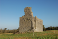
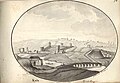
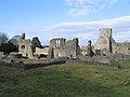
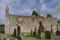
The Irish state has officially approved the following list of national monuments in County Kilkenny. In the Republic of Ireland, a structure or site may be deemed to be a "national monument", and therefore worthy of state protection, if it is of national importance. If the land adjoining the monument is essential to protect it, this land may also be protected.

Contents

National Monuments

NM#Monument nameDescriptionImageTownlandLocation
334 Aghaviller Church & Round Tower Aghaviller ruined church and round tower, Newmarket, Co. Kilkenny - geograph.org.uk - 206920.jpg Aghaviller 52°27′55″N7°16′05″W / 52.465167°N 7.2679167°W / 52.465167; -7.2679167
599 Ballyboodan Ogham Stone Ogham Stone (AD 700-900) Ogham stone by side of lane, Ballyboodan, Knocktopher, Co. Kilkenny - geograph.org.uk - 206902.jpg Ballyboodan 52°28′12″N7°13′22″W / 52.4701036°N 7.2226583°W / 52.4701036; -7.2226583
282 Ballylarkin Church Church Ballylarkin Church.png Ballylarkin Upper 52°43′22″N7°25′39″W / 52.722866°N 7.427629°W / 52.722866; -7.427629
475 Callan Augustinian Friary Friary (Augustinians) Callanaugustinianfriary.jpg Callan North 52°32′45″N7°23′14″W / 52.545787°N 7.387348°W / 52.545787; -7.387348
455 Callan Church (St. Mary's)Church St. Mary's Church, Callan - geograph.org.uk - 1479408.jpg Callan South 52°32′39″N7°23′25″W / 52.544064°N 7.39015°W / 52.544064; -7.39015
79 Kilkieran High Crosses High Crosses Kilkieran Cross.JPG Castletown (Iverk barony) 52°23′52″N7°22′51″W / 52.397809°N 7.380761°W / 52.397809; -7.380761
274 Clara Castle Castle Clara Castle - geograph.org.uk - 494292.jpg Clara Upper 52°40′10″N7°09′08″W / 52.669444°N 7.152168°W / 52.669444; -7.152168
77 Clonamery Church Church Clonamery 52°28′01″N7°01′54″W / 52.466927°N 7.031789°W / 52.466927; -7.031789
646 Coolhill Castle Donjon Tower at Coolhill, Co. Kilkenny - geograph.org.uk - 1104747.jpg Coolhill 52°27′54″N6°55′56″W / 52.464942°N 6.932191°W / 52.464942; -6.932191
321 Burnchurch Castle Castle & Tower Burnchurch Castle ruins.jpg Farmley 52°34′34″N7°17′51″W / 52.576039°N 7.297509°W / 52.576039; -7.297509
522 Magdalan Castle Castle Magdalan Castle.jpg Gardens
Kilkenny City
52°39′10″N7°14′41″W / 52.652673°N 7.244756°W / 52.652673; -7.244756
331, 344 St. John's Abbey, Kilkenny Priory (Augustinian) (part of & chancel) St johns priory Kilkenny.jpg Gardens
Kilkenny City
52°39′13″N7°14′54″W / 52.653549°N 7.248406°W / 52.653549; -7.248406
626 Kells Castle Motte & Bailey Kells, Co Kilkenny, 1794.jpg Garrynamann Lower
Kells, County Kilkenny
52°32′18″N7°16′01″W / 52.538333°N 7.266944°W / 52.538333; -7.266944
214 St. Mary's Collegiate Church Gowran Collegiate Church St Mary's Church, Gowran, Co. KIlkenny - geograph.org.uk - 207654.jpg Gowran 52°37′45″N7°03′48″W / 52.6292°N 7.0633°W / 52.6292; -7.0633
620 Graiguenamanagh Abbey Abbey (Cistercians) Graiguenamanach Choir Window SE 1997 08 27.jpg Graiguenamanagh 52°32′27″N6°57′16″W / 52.54076°N 6.954525°W / 52.54076; -6.954525
74 Grangefertagh Round Tower & Church Fertagh Round Tower Limerick March 2008.JPG Grangefertagh 52°46′42″N7°32′41″W / 52.77841°N 7.544691°W / 52.77841; -7.544691
80 Jerpoint Abbey Abbey (Cistercian) Jerpoint Abbey E 1997 08 28.jpg Jerpointabbey 52°30′39″N7°09′28″W / 52.510713°N 7.157804°W / 52.510713; -7.157804
300 Kilfane Church Church Kilfane-Church04.jpg Kilfane Demesne 52°33′15″N7°07′06″W / 52.554055°N 7.118406°W / 52.554055; -7.118406
75 Killamery High Cross High Cross Killamery High Cross, Kilkenny.jpg Killamery 52°28′31″N7°26′45″W / 52.475389°N 7.445971°W / 52.475389; -7.445971
324 Kilmogue Portal Tomb Portal Tomb Portal Tomb Kilmogue Leacan Scoil.jpg Kilmogue, Harristown 52°24′11″N7°15′45″W / 52.403077°N 7.2625°W / 52.403077; -7.2625
76 Kilree Church, Round Tower & Cross Kilree.jpg Kilree 52°31′05″N7°16′07″W / 52.518108°N 7.268573°W / 52.518108; -7.268573
655 Knockroe Passage Tomb Passage Tomb Passage tomb Knockroe County Kilkenny.jpg Knockroe (Kells, Killamery) 52°25′54″N7°23′59″W / 52.43175°N 7.39981°W / 52.43175; -7.39981
399 Dunmore Cave Cave Dunmore cave, County Kilkenny.jpg Ballyfoyle 52°44′02″N7°14′48″W / 52.733946°N 7.246579°W / 52.733946; -7.246579
180 Kells Priory Priory (Augustinian) Kellsp2.JPG Rathduff (Madden) 52°32′19″N7°16′01″W / 52.538632°N 7.266906°W / 52.538632; -7.266906
376 Rathealy Ringfort Ringfort Rathealy 52°41′41″N7°25′57″W / 52.694722°N 7.432625°W / 52.694722; -7.432625
73 Sheepstown Church Church Sheepstown ruined church, Knocktopher, Co. Kilkenny - geograph.org.uk - 207631.jpg Sheepstown 52°29′06″N7°14′36″W / 52.485080°N 7.243442°W / 52.485080; -7.243442
72 St. Francis Abbey (Kilkenny)Friary (Franciscan) Kilkenny Friary as seen from the Round Tower 2007 08 28.jpg St. Mary's Parish 52°39′21″N7°15′12″W / 52.655926°N 7.253431°W / 52.655926; -7.253431
191 Thomastown Church Church Old Thomastown Church.png Thomastown 52°31′33″N7°08′22″W / 52.525937°N 7.139316°W / 52.525937; -7.139316
161 Tullaherin Round Tower Tullaherin Monastic site.jpg Tullaherin 52°34′45″N7°07′50″W / 52.579284°N 7.130428°W / 52.579284; -7.130428
670 Tullaroan Church Church Tullaroan church ruin Interior (geograph 6179484).jpg Tullaroan 52°39′29″N7°26′01″W / 52.658076°N 7.43363°W / 52.658076; -7.43363
78 Ullard Church Church Ullard Church 1997 08 28.jpg Ullard 52°34′49″N6°55′59″W / 52.580162°N 6.932934°W / 52.580162; -6.932934
372 Callan Motte Motte Moatcallan.jpg Westcourt Demesne 52°32′48″N7°23′29″W / 52.546749°N 7.391368°W / 52.546749; -7.391368
St. Lachtain's Church, Freshford Church St Lachtain's Church.png Freshford Lots 52°43′58″N7°23′52″W / 52.73269°N 7.39785°W / 52.73269; -7.39785
Shee Alms House Almshouse Shee Alms House, Kilkenny - geograph.org.uk - 3650836.jpg Gardens 52°39′05″N7°15′06″W / 52.65144°N 7.25155°W / 52.65144; -7.25155
Kyteler's Inn Public house Kyteler's Inn.jpg Gardens 52°39′11″N7°15′12″W / 52.65319°N 7.25333°W / 52.65319; -7.25333
Archer Mansionearly modern townhouse Gardens 52°39′05″N7°15′11″W / 52.65147°N 7.25313°W / 52.65147; -7.25313
Rothe House early modern townhouse Rothe House 2021.jpg Gardens 52°39′15″N7°15′18″W / 52.65425°N 7.25487°W / 52.65425; -7.25487

See also

Related Research Articles

<span class="mw-page-title-main">Ancient Monuments Protection Act 1882</span> Act of the Parliament of the United Kingdom

The Ancient Monuments Protection Act 1882 was an Act of the Parliament of the United Kingdom of Great Britain and Ireland. It was introduced by John Lubbock, 1st Baron Avebury, recognising the need for a governmental administration on the protection of ancient monuments, and was finally passed after a number of failed attempts on heritage protection acts. The gradual change towards a state-based authority responsible for the safeguarding of the Kingdom's national heritage manifested itself through the appointment of the first Inspector of Ancient Monuments in 1882, General Pitt Rivers.

<span class="mw-page-title-main">Burnchurch Castle</span> 15th-century tower house in County Kilkenny, Ireland

Burnchurch Castle, a National Monument, is a well-preserved 15th century Norman tower house with a round gate tower, situated in the parish of Burnchurch, County Kilkenny, Ireland. Burnchurch Castle and tower, along with the Church of Ireland church, and the lime trees became a National Monument in 1993.

<span class="mw-page-title-main">National monument (Ireland)</span> Monument assigned national importance in Ireland

A national monument in the Republic of Ireland is a structure or site, the preservation of which has been deemed to be of national importance and therefore worthy of state protection. If the land adjoining the monument is essential to protect it, this land may also be protected.

References