Related Research Articles
The Dümmer or officially Dümmer See is a large lake in southern Lower Saxony (Germany). It has a surface of 13.5 km2 and an average depth of one metre. Its elevation is 37 metres.

Wangerooge is one of the 32 Frisian Islands in the North Sea located close to the coasts of the Netherlands, Germany and Denmark. It is also a municipality in the district of Friesland in Lower Saxony in Germany.

The Gose is a small river in Lower Saxony, Germany. It is a left tributary of the Abzucht. The river is 7.1 kilometres (4.4 mi) long with a drainage basin of 10 km2 (3.9 sq mi). Its source lies north of Auerhahn in the Harz Mountains, on the eastern slopes of Bocksberg. The river runs towards the northeast through a steep and narrow valley and meets the Abzucht on the western edge of Goslar, which is named after the river. Its water was once used in the brewing of the traditional Gose beer.

Baltrum is a barrier island off the coast of East Frisia, in Germany, and is a municipality in the district of Aurich, Lower Saxony. It is located in-between the chain of the seven inhabited East Frisian Islands. Baltrum is the smallest island in this chain by area and inhabitants. It has a land area of 6.5 square kilometres, and a population in (2011) of just over 500 resident inhabitants.
Lohne (Oldenburg) (Northern Low Saxon: Lohn) is a town in the district of Vechta, in Lower Saxony, Germany. It is located approximately 8 km south-west of Vechta. The town lies on the A1 freeway between Bremen and Osnabrück.

Sankt Andreasberg is a former town in the district of Goslar, in Lower Saxony, Germany. Since 1 November 2011, it is part of the town Braunlage. It is situated in the Harz, approximately 7 km west of Braunlage proper, and 20 km east of Osterode am Harz.

The Großes Moor near Becklingen is a nature reserve in Germany with an area of 850 hectares, of which 666 hectares lie in Celle district and 184 hectares in Soltau-Fallingbostel district. Since 16 December 1985 the area has been protected under conservation law. An area of 776.6 hectares is designated as a special area of conservation (FFH-Gebiet). The name literally means "Large Bog near Becklingen" and it lies on the Lüneburg Heath, south of Wietzendorf and east of Becklingen, part of the borough of Bergen. The River Meiße has its source in this raised bog.

Drömling is a sparsely populated depression on the border of Lower Saxony and Saxony-Anhalt in Germany with an area of about 340 square kilometres (130 sq mi). The larger part belonging to Saxony-Anhalt in the east has been a nature park since 1990. The former swampland was transformed by drainage from a natural into a cultural landscape in the 18th century under the direction of Frederick the Great of Prussia. Today the depression, with its waterways, the Mittelland Canal and the rivers Aller and Ohre is a refuge for rare or endangered species of animal and plant. Most of the area is now made up of nature reserves and protected areas. Nearby towns include Oebisfelde and Wolfsburg.
The Aller Canal is a canal built in the mid-19th century in the German state of Lower Saxony. The canal is 18 kilometres (11 mi) long and runs between Wolfsburg and Gifhorn. It was built to protect agricultural land from flooding by the river Aller. The nearly straight canal carries water from the Aller more quickly than the river itself can in its meandering course through this section of the old glacial valley.

Söse is a river of Lower Saxony, Germany. It is a right tributary of the river Rhume and 38 kilometres (24 mi) long.

The Geeste is a river in Lower Saxony, Germany. It rises near the village of Hipstedt and falls into the Weser at Bremerhaven after a course of some 40 km (25 mi). It is the Weser's lowest tributary. The lower reaches of the Geeste are navigable and form part of the Elbe–Weser waterway.

The Ochtum is a river in Lower Saxony and Bremen, Germany. Roughly 26 km (16 mi) long, it is a left tributary of the Weser.
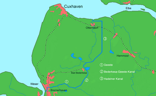
The Elbe–Weser waterway or Elbe–Weser shipping channel is a short-cut between the rivers Elbe and Weser in North Germany which is part-canal and part-river. It has a length of 54.7 kilometres (34.0 mi) and is designed for smaller coastal vessels. It includes some 60 kilometres (37 mi) of canal dykes and 45 kilometres (28 mi) of canal paths. The channel starts in Otterndorf with the Hadeln Canal, then becomes the Bederkesa-Geeste Canal from the town of Bad Bederkesa to the River Geeste, the final leg of the shipping channel, which flows into the Weser at Bremerhaven. It is owned by the state of Lower Saxony, maintained by the NLWKN from its Stade office. Today they just look after maintenance of the drainage system, because the economic element of the canal – commercial shipping which was particularly thriving in the late 1960s – declined increasingly from 1973 onwards and today hardly exists at all. Nevertheless, the waterway is still used by smaller yachts as a short cut between Elbe and Weser.

The Aschau is a stream in the Südheide Nature Park in Lower Saxony, Germany, It is a tributary of the Lachte, which in turn discharges into the Aller.
The Lower Saxon Department for Water, Coastal and Nature Conservation or NLWKN is a department of the state of Lower Saxony, with its headquarters in Norden (Ostfriesland) and is responsible to the Minister for the Environment and Climate Protection.

The Aper Tief is a stream in Lower Saxony, Germany.

The Aa is a 20.6 km long, orographic left tributary of the Nethe river in North Rhine-Westphalia, Germany. The Aa belongs as a tributary of the Nethe to the river system of the Weser.

The Gande is a river of Lower Saxony, Germany. It is a right-hand tributary of the River Leine.

The Ewiges Meer is the largest raised bog lake in Germany, with an area of 91 hectares. Its surface lies at about 8.5 metres above sea level (NN). The lake is surrounded by an extensive complex of unutilised areas, that exhibit the actual raised bog profile and, together with the lake, form the Ewiges Meer Nature Reserve which covers an area of 1,290 hectares.

The nature reserve of Rehden Geest Moor is an extensive, open raised bog in the collective municipality of Rehden, in the county of Diepholz in Lower Saxony. It is a representative raised bog for the natural region known as the Diepholz Moor Depression. According to GIS it covers an area of 1,736 hectares, but according to the conservation act, 1,786 hectares.
References
- ↑ http://www.nlwkn.niedersachsen.de/master/C8380003_N5512608_L20_D0_I5231158.html Accessed on 16.09.2009