Related Research Articles
Nepal is a landlocked mountainous country where transportation is difficult due to the terrain.

Indian Railways (IR) is a statutory body under the ownership of the Ministry of Railways, Government of India that operates India's national railway system. It manages the fourth largest national railway system in the world by size, with a total route length of 68,043 km (42,280 mi), running track length of 102,831 km (63,896 mi) and track length of 128,305 km (79,725 mi) as of 31 March 2022. 58,812 km (36,544 mi) of all the gauge routes are electrified with 25 kV 50 Hz AC electric traction as of 1 April 2023.
The East Central Railway is one of the 19 railway zones in India. It is headquartered at Hajipur and comprises Sonpur, Samastipur, Danapur, Pt. Deen Dayal Upadhyaya, and Dhanbad divisions.
Ircon International, or Indian Railway Construction International Limited (IRCON), is an Indian engineering & construction corporation, specialized in transport infrastructure. The public sector undertaking was established in 1976, by the Indian Railways under the Indian Companies Act 1956. IRCON was registered as the Indian Railway Construction International Limited, a wholly owned entity of the Indian Railways. Its primary charter was the construction of railway projects in India and abroad. Ircon has since diversified into other transport and infrastructure segments and with its expanded scope of operations around the world, the name was changed to Indian Railway International Ltd. in October 1995.

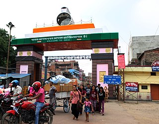
Birganj is a metropolitan city in Parsa District in Madhes Pradesh in southern Nepal. It lies 135 km (84 mi) south of the capital Kathmandu, attached in the north to Raxaul on the border of the Indian state of Bihar. As an entry point to Nepal from Patna, Birganj is known as the "Gateway of Nepal". It is also called the "Commercial Capital of Nepal". The town has significant economic importance for Nepal as most of the trade with India is via Birganj and the Indian town of Raxaul. The Tribhuvan Highway links Birgunj to Nepal's capital, Kathmandu.

Zhangmu, Dram, or Khasa in Nepali, is a customs town and port of entry located in Nyalam County on the Nepal-China border, just uphill and across the Bhote Koshi River from the Nepalese town of Kodari. At 2,300 metres (7,500 ft) above sea level, Zhangmu has mild and humid subtropical climate, which is a rarity for Tibet.
Bindyabasini is a rural municipality in Parsa District in Province No. 2 of Nepal. It was formed in 2016 occupying current 5 sections (wards) from previous 5 former VDCs. It occupies an area of 26.04 km2 with a total population of 24,468. It now consists of 5 wards of 14 small villages
Sonauli is a town, near city of Maharajganj in Maharajganj district in Uttar Pradesh, India. It located on the Indo-Nepal Border and is a well-known and most famous transit point between India and Nepal.
The Tribhuvan Highway connects the outskirts of Kathmandu, the capital of Nepal, with Birganj/Raxaul on the Nepal-India border. NH 28 and NH 28A links Raxaul with Lucknow/Barauni and other locations in India.

Kodari is a small village located at the border with Tibet-China. The village is located at the end–point of the Arniko Highway, which connects Kodari with the capital city of Kathmandu. Kathmandu is 144 kilometres (89 mi) away from Kodari. Kodari is a major border crossing from Nepal into the Tibet Autonomous Region.
The Barauni–Katihar, Saharsa and Purnia sections of the Barauni–Guwahati line connects Barauni, Saharsa, Purnia and Katihar in the Indian state of Bihar.

The Lhasa–Xigazê railway, or La'ri railway, is a high-elevation railway that connects Lhasa to Xigazê, in the Tibet Autonomous Region. The travel time between Lhasa and Xigazê on this line is roughly three hours.

The Barauni–Gorakhpur, Raxaul and Jainagar lines are a set of three lines connecting Barauni in the Indian state of Bihar with Gorakhpur in Uttar Pradesh. The lines run in an east–west direction between the Ganges and India-Nepal border, covering northern Bihar west of the Kosi river and eastern Uttar Pradesh. The southernmost of the lines connects via Hajipur Junction, Sonpur Junction,Chhapra and Siwan Junction. The central line connects via Muzaffarpur, Motihari and Sugauli. The northern line connects via Darbhanga, Sitamarhi and Raxaul. The lines have interconnections between them and the northern line has extensions to places near the India–Nepal border.
Laukaha Bazar railway station serves Laukaha town in Madhubani district in the Indian state of Bihar. It located near the India–Nepal border.
The Muzaffarpur–Gorakhpur line is a set of three lines connecting Muzaffarpur in the Indian state of Bihar with Gorakhpur in Uttar Pradesh. The lines run in an east–west direction between the Gandak and India–Nepal border, covering North Bihar west of the Kosi river and eastern Uttar Pradesh. The southernmost of the three lines connects via Hajipur Junction, Sonpur Junction and Chhapra. The central line connects via Motihari and Sugauli. The northern line connects via Sitamarhi and Raxaul. The lines have interconnections between them and the northern line has extensions to places near the India–Nepal border.

Jaynagar railway station is a main terminal railway station in Madhubani district, Bihar. Its code is JYG. It serves Jainagar and the surrounding areas. The station consists of 5 platforms.
The China–Nepal Railway is a planned railway between China and Nepal. The railway will link Kathmandu with Shigatse, Tibet, crossing the China–Nepal border at Gyirong–Rasuwa.

The India-Nepal border is an open international boundary running between the republics of India and Nepal. The 1,770 km (1,099.83 mi) long border includes the Himalayan territories as well as Indo-Gangetic Plain of the subcontinent. The current border was delimited after the Sugauli treaty of 1816 between Nepal and the British Raj. Following Indian independence, the prevailing border was recognised as the international border between the Kingdom of Nepal and the Dominion of India.
Thadi or Thadi Viswaspatti is a very old border town and a market place of Nepal in Siraha District bordering Indian town of Laukaha. It is currently part of Bhagwanpur Rural municipality. It is located nearly 370 kilometers or 107 miles east of the capital, Kathmandu. Thadi was part of Tirhut Rulers of Simraungarh. The region was under rule of Karnad Dynasty formed by Nanyadeva Thadi is one of the few towns which is a part of agreed route for Mutual Trade between India and Nepal. Nepal Government has set up a dedicated customs office in the town.
The Trans-Himalayan Multi-dimensional Connectivity Network is an economic corridor between Nepal and China and part of China's Belt and Road Initiative, a global development initiative that develops connectivity especially across Eurasia. During a state visit to Nepal in 2019, the corridor was hailed by Chinese President and General Secretary of the Communist Party Xi Jinping as changing Nepal "from a landlocked to a land-linked country."