Stations


Railway stations in Armenia include:

The London Underground is a rapid transit system serving Greater London and some parts of the adjacent home counties of Buckinghamshire, Essex and Hertfordshire in England.

The Tube map is a schematic transport map of the lines, stations and services of the London Underground, known colloquially as "the Tube", hence the map's name. The first schematic Tube map was designed by Harry Beck in 1931. Since then, it has been expanded to include more of London's public transport systems, including the Docklands Light Railway, London Overground, the Elizabeth line, Tramlink, the London Cable Car and Thameslink.
This page provides an index of articles on rail transport by country.

Kensington (Olympia) is a combined rail and tube station in Kensington, in West London. Services are provided by London Overground, who manage the station, along with Southern and London Underground. It is in Travelcard Zone 2. On the Underground it is the terminus of a short District line branch from Earl's Court, originally built as part of the Middle Circle. On the main-line railway it is on the West London Line from Clapham Junction to Willesden Junction, by which trains bypass inner London. The station's name is drawn from its location in Kensington and the adjacent Olympia exhibition centre in West Kensington.

The Trans-European Transport Network (TEN-T) is a planned network of roads, railways, airports and water infrastructure in the European Union. The TEN-T network is part of a wider system of Trans-European Networks (TENs), including a telecommunications network (eTEN) and a proposed energy network. The European Commission adopted the first action plans on trans-European networks in 1990.

The Northern Line is a commuter rail line operated by Sydney Trains in Sydney, New South Wales, Australia. It serves some of Sydney's Inner West and Northern suburbs. It was spun off from the old T1 North Shore, Northern & Western Line as a separate line in April 2019, to distinguish and make it more easily identified from the other T1 services. It is also a reincarnation of the older Northern Line which was under operation until 2013.

Rail freight transport is the use of railroads and trains to transport cargo as opposed to human passengers.

The Islamic Republic of Iran Railways is the national state-owned railway system of Iran. The Raja Passenger Train Company is an associate of the IR, and manages its passenger trains. The Railway Transportation Company is an associate of the IR, which manages its freight transport. The Ministry of Roads & Urban Development is the state agency that oversees the IRIR. Some 33 million tonnes of goods and 29 million passengers are transported annually by the rail transportation network, accounting for 9 percent and 11 percent of all transportation in Iran, respectively (2011).
A rail transport company is a company active within the rail industry. It can be:

Turkey has a state-owned railway system built to standard gauge which falls under the remit of the Ministry of Transportation and Infrastructure. The primary rail carrier is the Türkiye Cumhuriyeti Devlet Demiryolları (TCDD) which is responsible for all long-distance and cross-border freight and passenger trains. A number of other companies operate suburban passenger trains in urban conurbations.

The Kars–Gyumri–Tbilisi railway line is a railway line that runs from the city of Kars in Turkey to the Armenian city of Gyumri, and from there on to Tbilisi, Georgia.

The Baku–Tbilisi–Kars (BTK), or Baku–Tbilisi–Akhalkalaki–Kars railway (BTAK), is a railway connecting Azerbaijan, Georgia and Turkey, which became operational on 30 October 2017 following several years of delays. The project was originally due to be completed by 2010, but was delayed to 2013, 2015, 2016, and, following a fifth trilateral meeting in February 2016, foreign ministers of the three countries announced that the railway would finally be completed in 2017.

Georgian Railway LLC is the national railway company of Georgia.

Rail transport in Azerbaijan is operated by the national state-owned railway company Azerbaijan Railways. The railway network consists of 2,918 km (1,813 mi), its gauge is 1,520 mm, 815 km (506 mi) are double track and 1,272 km (790 mi) are electrified at 3 kV (3,000 V) DC.

The International North–South Transport Corridor (INSTC) is a 7,200-km long multi-mode network of ship, rail, and road route for moving freight between India, Iran, Azerbaijan, Russia, Central Asia and Europe. The route primarily involves moving freight from India, Iran, Azerbaijan and the Russian Federation via ship, rail and road. The objective of the corridor is to increase trade connectivity between major cities such as Mumbai, Moscow, Tehran, Baku, Bandar Abbas, Astrakhan, Bandar Anzali, etc. Dry runs of two routes were conducted in 2014, the first was Mumbai to Baku via Bandar Abbas and the second was Mumbai to Astrakhan via Bandar Abbas, Tehran and Bandar Anzali. The objective of the study was to identify and address key bottlenecks. The results showed transport costs were reduced by "$2,500 per 15 tons of cargo". Other routes under consideration include via Kazakhstan and Turkmenistan.

Azerbaijan Railways is the national state-owned rail transport operator in the Republic of Azerbaijan. The 2,918 km (1,813 mi), 1,520 mm gauge network is electrified at 3 kV (3,000 V) DC. The headquarters of the Azerbaijan Railways is in the capital Baku.
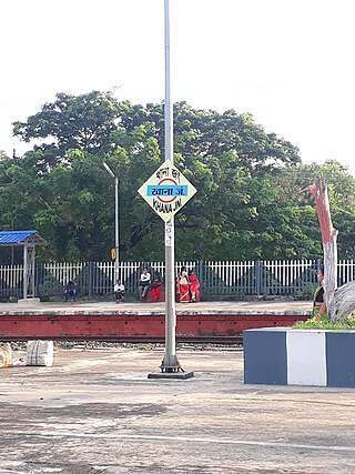
Khana Junction is a railway station in Bardhaman Sadar North subdivision of Purba Bardhaman district in the Indian state of West Bengal.

South Caucasus Railway is the sole railway company in Armenia, owned by Russian Railways, responsible for all inter-city, commuter, and freight rail transport in Armenia. The network consists of 780 kilometers of track with all lines in the Russian gauge.

Yerevan railway station is the central station of Yerevan, the capital of Armenia, located south of downtown Yerevan, approximately 2.8 km from Republic Square.
Wrexham North is a proposed railway station on the Shrewsbury–Chester line, situated between Rossett and Wrexham, in Wrexham County Borough, Wales. As of January 2022, there is no definitive site for the proposed station, with proposals including: the former Rossett railway station or a station near Pandy, Wrexham and Gresford. Unless construction of the station south of Rossett coincides with the full or partial dualling of the currently single track railway line towards Stansty, Wrexham North may be a single platform station or if situated at Rossett Junction be linked by a single track southwards to Wrexham.
| Metros | |
|---|---|
| Trolleybuses | |
| South Caucasus Railway |
|
| Tourist |
|
| Major terminals |
|
| Defunct | |
| |