List of streets in East Perth

Last updated

The suburb name was being used unofficially from at least the 1880s, but East Perth wasn't officially approved as a bounded suburb until 1954. [1]

NameDate builtName sourceOther name(s)NotesImage
Adelaide Terrace
Arden Streetc1837
Bakery Lane
Bay Streetby 22 June 1845Erskine"Bay Street ran down to a small bay near the Causeway, at the end of the town." [2]
Beacon Terrace
Bennett Street"There is no information on record concerning Bennett Street." [2]

"Maiden name of Matilda Roe, wife of the first Surveyor General of Western Australia." [3]

Matilda Roe (née Bennett) 1808-1870. Married John Septimus Roe on 8 January 1829 and came straight to...()

Bennett Street (1838): After Mrs J S Roe (J S Roe was the first Surveyor-General of WA). Her maiden name was Matilda Bennett. [4]

Bishops Row
Boans Lane
Bramall Street
Bremer Promenade
Bridge Street
Bronte Street1899 22 Feb Horatio Nelson "Admiral Lord Horatio Nelson. Duke of Bronte, famous Commander in Chief of the Royal Navy (1803-1805)." [3]

Bronte Street (1845): After Lord Nelson, Duke of Bronte. [4]

Brook Streetc1845Along Claise Brook
Brown Streetby 22 June 1845 Peter Nicholas Brown "Peter Nicholas Brown, Colonial Secretary of Western Australia (1829-1846) and original grantee of land in the area." [Wasn't he Broun?] Brown Street (1838): After Peter Brown, Col. Secretary of WA, 1836, and original grantee of Locn A1 near extension of street east in about 1913. [4]
Bunbury Crescentc1838
Burt Way
The Causeway East off Riverside Drive across Heirisson Island / West onto Riverside Drive from Heirisson Island 20180226cb See: Causeway Bridge Perth 6000 20180312cb
City Farm Placec1838
Clotilde Street
Constitution Street
Coolgardie Terrace
De Vlamingh Avenue
East Parade
Eastbrook Terrace
Ensign Lane
Erskine Link See: Bay Street Perth 6000 and Northbridge 6003
Fielder Street
Flagstaff Lane
Forrest Avenue
Gardiner Street James Gardiner Gardiner Street, East Perth named after Honourable James Gardiner (12 June 1861 – 27 October 1928) was an Australian politician who served in the Legislative Assembly of Western Australia from 1901 to 1904 and from 1914 to 1921. He served as colonial treasurer under two premiers, Walter James and Henry Lefroy. Gardiner was also the inaugural state leader of the Country Party from 1914 to 1915, and briefly served as Speaker of the Legislative Assembly from March to June 1917.r

Not to be confused with Gardner Street in West Perth, which is now known as Simpson Street [5]

Gibraltar Way
Glyde Street
Goderich Street1829 Aug-Sep Frederick John Robinson "Frederick John Robinson, who was created Viscount Goderich in 1827." [6]

"...the names of Goderich and Lord Streets in East Perth ...Frederick John Robinson, the Prime Minister in 1827-1828 and Secretary for War and the Colonies from 1830 to 1833 was created Viscount Goderich in 1827. Hence the names Lord and Goderich." [2]

Goongoongup Bridge 1995

24 July

Perth's city 3 road bridge over the river. Was originally only a rail bridge for suburban non electric passenger single track services prior to the 1990s. Present day bridge now has the dual carriageway Graeme Farmer Freeway and the electrified dual track Perth-Armadale/Thornlie suburban commuter train (). "The original Bunbury Bridge (right) was a single line timber railway bridge which took the railway line across the Swan River at East Perth near where Claise Brook enters the river. It was built as part of the Armadale line, which was opened to traffic on 2nd May 1889. The original stations were Perth, Kelmscott and Armadale. Cannington and Welshpool opened later in 1897 and 1898 respectively. The bridge was named Bunbury Bridge because the line was to be extended to Bunbury in the state's south-west, which occurred in 1891. The present double track concrete structure called the Goongoonup Bridge was constructed and brought into operation in September 1991 when Perth's suburban railway lines were electrified. It replaced its aging predecessor, ending the days of 'crossing delays' forever. The latter was demolished at the beginning of 1996." (7 - To Be Confirmed)
Graham Farmer Freeway 2000 April Graham (Polly) Farmer
Haig Park Circle
Hale Streetc 1875 Matthew Blagden Hale "Bishop Matthew Blagden Hale, appointed first Anglican Bishop of Western Australia in 1857." [3]
Hay Street c1836 Robert William Hay Twiss Street
Henry Street
Henry Lawson Walk
Hill Street1829

Aug-Sep

Rowland Hill Hill Street (1838): After Lord Rowland Hill, Commander-in-Chief of Imperial Forces, England, 1825-36. [4]
Horatio Streetby 22 June 1845 Horatio Nelson "Lord Admiral Horatio Nelson, 1st Viscount Nelson (1758-1805)." [3] Horatio Street: After Lord Horatio Nelson. [4]
Jewell Lane
Joel Terrace
Kensington Street
King Streetby 1893P P KingRoyal StreetKing Street (1845): Named after Captain P P King, RN; near Wickham and Stokes streets, fellow navigator with King. Now part of Royal Street. [4]

This is not central Perth's King Street.

Leahy Walk
Lime Street
Little Brown Street
Little Saunders Street
Lord Street
Macey StreetBefore 1905"connection of Trafalgar- Road and Macey-street, £7". [7]
Maggs Lane
Meadow Street
Mine Lane
Moore Streetbefore 1838 George Fletcher Moore Moore Street (1838): After Geo Fletcher Moore, Advocate-General of WA, 1830-46. [4]
Moreau Parade
Mulberry Way
Nelson Avenue Horatio Nelson "Lord Admiral Horatio Nelson, 1st Viscount Nelson (1758-1805)." [3]
Nelson CrescentHoratio NelsonNelson Crescent (1845): After Lord Nelson. [4]
Nile Streetby 22 June 1845The Battle of the Nile "The Battle of the Nile, a famous battle of the Napoleonic Wars (1st and 2nd August, 1798) in which Lord Nelson led the British to victory. It was known in France as the Battle of Aboukir Bay. The original Nile Street was closed and included in Gloucester Park trotting grounds. The name, however, was transferred to Premier Street, the latter name being cancelled." [3] Nile Street (1845): Named after Nelson's Battle. Original street closed and its site granted in trotting grounds. Name now transferred to Premier Street, latter name being eliminated. [4]
Norbert Streetc1838
Old Belvidere Promenade
Old Buthers Lane
Orange AvenueOrange GroveOrange Avenue: Because through an old orange grove, 1896. Was part of "Gallop's Garden." In 1885 Mr Gallop was granted four acres fronting Lake Street as compensation for resumption of part of his allotment W1 to round off corner of Beaufort and Wellington streets, and eliminate an awkward break in continuity of Barrack Street. [4]
Orchard Way
Plain Streetby 22 June 1845"Origin unknown." [3]
Polar Street
Premier Lane
Regal Place
Renaissance Avenue
Riverside Drive Splits in two running east parallel with Adelaide Terrace and north/west over Adelaide Terrace 2080226cb
Royal StreetWater Street"Origin unknown." [3]
Saunders Street
Sovereign Close
Stokes Way
Summers Streetc1838
Terrace Road
Trafalgar Roadby 22 June 1845 The Battle of Trafalgar "The Battle of Trafalgar (21 October 1805) in the Napoleonic Wars in which Lord Nelson lost his life." [3]
Trinity AvenueTrinity College

Originally terminating eastern end of Hay Street. Renamed Trinity Avenue in 1991 after Catholic school established on the road in 1962 . Trinity was originally named CBC St George’s Terrace at 1 St George’s Terrace . Relocated and renamed in 1962.

Tully Road
Twiss Street1829

Aug-Sep

Horace Twiss Hay StreetRunning east from Bennett Street. No longer existent

"Hay Street took a twist at Bennett Street and was named Twiss Street after Horace Twiss, Parliamentary Under-Secretary of State for the Colonies." [6] "...(now Hay Street from Bennett Street to the Causeway). Horace Twiss (1787-1849), English writer and politician, Under Secretary of State for War and the Colonies 1830-1833. He took a great part in establishing the colony and was a personal friend of Governor Stirling." [3]

Vanguard Terrace
Victory Terrace
Waterloo Street1829

Aug-Sep

The Battle of Waterloo "Wellington Street was named after the famous general and Waterloo Street served as a reminder of the great battle he fought." [6] "Waterloo Street, which ran off at an angle from the east end of Wellington Street. These names were appropriately chosen, as the foundation of the Colony took place during the Duke of Wellington's Prime Ministership". [2] "The Battle of Waterloo, Belgium (18 June 1815) in which Napoleon Bonaparte was defeated by the British under Arthur Wellesley, 1st Duke of Wellington (1769-1852)." [3]
Waterloo Crescentc1838Runs east off Wellington Street 20180226cb
Wellington Street c1836 Duke of Wellington "Wellington Street was named after the famous general and Waterloo Street served as a reminder of the great battle he fought." [6]
Westralia Streetc1838
Wickham Place
Wickham Street1899

22 Feb

John Clements Wickham "John Clements Wickham (1798-1864). He was captain of HMS Beagle (the vessel occupied by Charles Darwin during his voyage of discovery) and conducted various maritime expeditions and scientific surveys along the Australian coastline during 1837-41. He was the first Government Resident at the Moreton Bay area of Brisbane, Queensland, where he was police magistrate from 1843." [3]

It is possible the article citing the construction of this street is merely the laying of concrete or "macadam" as it does not explicitly state that the street did not already exist prior to this. See reference #117[ clarification needed ]

Windan Bridge 2000

22 April

Named after a wife of Yellagonga chief of the Mooro tribe. [8]
Wittenoom Streetby 22 June 1845 John Burdett Wittenoom "Wittenoom-street, East Perth, perpetuates the name of one pioneer, the Rev J B Wittenoom." [9]
Zebina Street

See also

Related Research Articles

<span class="mw-page-title-main">Mount Lawley, Western Australia</span> Suburb of Perth, Western Australia

Mount Lawley is an inner northern suburb of Perth, Western Australia. The suburb is bounded by the Swan River to the east, Vincent, Harold and Pakenham Streets to the south, Central Avenue and Alexander Drive to the north, and Norfolk Street to the west.

<span class="mw-page-title-main">Leonora, Western Australia</span> Town in Western Australia

Leonora is a town in the Goldfields-Esperance region of Western Australia, located 833 kilometres (518 mi) northeast of the state capital, Perth, and 237 kilometres (147 mi) north of the city of Kalgoorlie.

<span class="mw-page-title-main">Wagin, Western Australia</span> Town in the Wheatbelt region of Western Australia

Wagin is a town and shire in the Wheatbelt region of Western Australia, approximately 225 km (139.81 mi) south-east of Perth on the Great Southern Highway between Narrogin and Katanning. It is also on State Route 107. The main industries are wheat and sheep farming.

<span class="mw-page-title-main">Albany Highway</span> Highway in Western Australia

Albany Highway links Western Australia's capital city Perth with its oldest settlement, Albany, on the state's south coast. The 405-kilometre-long (252 mi) highway travels through the southern Wheatbelt and Great Southern regions, and is designated State Route 30 for most of its length. Outside of Perth the highway is predominately a sealed, single carriageway with regular overtaking lanes in some undulating areas. Albany Highway commences at The Causeway, a river crossing that connects to Perth's central business district. The highway heads south-east through Perth's metropolitan region, bypassed in part by Shepperton Road and Kenwick Link, and continues south-eastwards through to Albany. It intersects several major roads in Perth, including the Leach, Tonkin, Brookton, and South Western highways. The rural section of Albany Highway connects to important regional roads at the few towns and roadhouses along the route, including Coalfields Highway at Arthur River, Great Southern Highway at Cranbrook, and Muirs Highway at Mount Barker.

<span class="mw-page-title-main">Swanbourne, Western Australia</span> Suburb of Perth, Western Australia

Swanbourne is a western coastal suburb of Perth, Western Australia, located within the City of Nedlands. It is an affluent, upper middle class residential area with older Federation style homes, many being renovated. The suburb was established in the late 19th century. New housing estates have been built recently through the redevelopment of areas such as the Swanbourne Senior High School, Swanbourne Primary School and Lakeway Drive-In Cinema sites.

<span class="mw-page-title-main">ABC Radio Perth</span> Radio station in Perth, Western Australia

ABC Radio Perth is the on-air identifier of a radio station located in Perth, Western Australia, operated by the Australian Broadcasting Corporation, and broadcasting at 720 kHz AM. It is the flagship ABC Local Radio station in Western Australia. The station was established under the Sealed Set scheme by Westralian Farmers in 1924, sold to the Commonwealth Government in 1928 and provided with programmes by the Australian Broadcasting Company, became part of the Australian Broadcasting Commission in 1932, which became the Australian Broadcasting Corporation in 1983.

<span class="mw-page-title-main">South Fremantle, Western Australia</span> Suburb of Perth, Western Australia

South Fremantle is a suburb of Perth, Western Australia, located within the City of Fremantle.

<span class="mw-page-title-main">Crawley, Western Australia</span> Suburb of Perth, Western Australia

Crawley is an affluent western suburb of Perth, the capital city of Western Australia. Whole area is part of the local government area of the City of Perth and previously shared between the City of Subiaco and City of Perth. It is about 5.8 kilometres (4 mi) from the Perth CBD via Mounts Bay Road.

<span class="mw-page-title-main">Coffee palace</span> Type of residential hotel

A coffee palace was an often large and elaborate residential hotel that did not serve alcohol, most of which were built in Australia in the late 19th century.

<span class="mw-page-title-main">Dorrien Gardens</span> Sports ground in West Perth, Western Australia

Dorrien Gardens is a sports ground in West Perth, Western Australia primarily used for soccer. It is the home ground of Perth SC.

<span class="mw-page-title-main">Kalgoorlie railway station</span> Railway station in Kalgoorlie, Western Australia

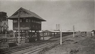
Kalgoorlie railway station is the easternmost attended station in Western Australia, located at the eastern terminus of the Eastern Goldfields Railway. It serves the city of Kalgoorlie. Beyond Kalgoorlie, the line continues east as the Trans-Australian Railway.

<span class="mw-page-title-main">Fremantle Customs House</span> Heritage building and former Customs House in Fremantle, Western Australia

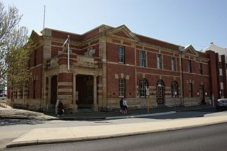
The Old Customs House is a building in Fremantle, Western Australia that was built in 1908 to house the main branch of the Customs Department of Western Australia. It is one of only a handful of extant Customs Houses in the state; others are in Albany, Broome, Cossack, and Geraldton.

<span class="mw-page-title-main">Guildford Road</span> Road in Perth, Western Australia

Guildford Road is a major road in Perth, Western Australia, linking the inner-city suburb of Mount Lawley with Guildford in the north-east. The ten-kilometre-long (6.2 mi) road runs mostly parallel to the Swan River, on its northern side, and is part of State Route 51, which runs between Perth's CBD and Midvale. Guildford Road is maintained and controlled by Main Roads Western Australia, which uses the internal designation "H026 Guildford Road" for Guildford Road, as well as Bridge Street and James Street in Guildford. In the 1930s, the name Great Eastern Highway was coined to describe the road, but was actually used for the road on the other side of the Swan River.

The Coolgardie Miner was a weekly newspaper established in Coolgardie, Western Australia, at a time when Coolgardie was the prominent town in the goldfields region of Western Australia.

<span class="mw-page-title-main">Mundaring Hotel</span> Hotel in Mundaring, Australia

The Mundaring Hotel was opened in 1899 in Mundaring, a hills suburb of Perth, Western Australia.

Erskine Link, once known as Bay Street, is situated in East Perth between Hay Street and Adelaide Terrace.

References

  1. "Historical Suburb Names". Landgate, Government of WA.
  2. 1 2 3 4 "Perth Street Names". The West Australian . Vol. XLVII, no. 8, 900. Western Australia. 1 January 1931. p. 8. Retrieved 17 May 2018 via National Library of Australia.
  3. 1 2 3 4 5 6 7 8 9 10 11 12 "Perth For Everyone: Perth's City Street Names". Perth for Everyone, 2011. 22 February 2014. Archived from the original on 22 February 2014. Retrieved 17 May 2018.
  4. 1 2 3 4 5 6 7 8 9 10 "Perth Streets". Sunday Times (Perth) . No. 1645. Western Australia. 4 August 1929. p. 12 (Second Section). Retrieved 17 May 2018 via National Library of Australia.
  5. "Post Office Directories | State Library". slwa.wa.gov.au. State Library of WA. Retrieved 17 May 2018.
  6. 1 2 3 4 "Streets of Perth". Western Mail . Vol. XLII, no. 2, 178. Western Australia. 10 November 1927. p. 2. Retrieved 17 May 2018 via National Library of Australia.
  7. "MUNICIPAL COUNCILS". Daily News. 29 August 1905. Retrieved 2 June 2023.
  8. Aboriginal place names : Mooro, Beeliar tribal territories : pre-European settlement, 1997, retrieved 6 September 2021|
  9. "Street Names Tell Perth's History". Daily News . Vol. LV, no. 18, 837. Western Australia. 3 August 1935. p. 18 (LATE CITY). Retrieved 17 May 2018 via National Library of Australia.