Related Research Articles
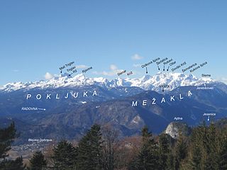
The Julian Alps are a mountain range of the Southern Limestone Alps that stretch from northeastern Italy to Slovenia, where they rise to 2,864 m at Mount Triglav, the highest peak in Slovenia and of the former Yugoslavia. A large part of the Julian Alps is included in Triglav National Park. The second highest peak of the range, the 2,755 m high Jôf di Montasio, lies in Italy.

Col du Tourmalet is one of the highest paved mountain passes in the French Pyrenees, in the department of Hautes-Pyrénées. Sainte-Marie-de-Campan is at the foot on the eastern side and the ski station La Mongie two-thirds of the way up. The village of Barèges lies on the western side, above the town of Luz-Saint-Sauveur.
This is a list of the extreme points of Europe: the geographical points that are higher or farther north, south, east or west than any other location in Europe. Some of these positions are open to debate, as the definition of Europe is diverse. The most western town of continental Europe is Peniche with coordinates: 39°21′N 9°22′W

The Albula Pass is a Swiss mountain pass in the canton of Graubünden. It lies at the heart of the Albula Alps, on the watershed between the Albula, tributary of the Rhine and the Ova d'Alvra, tributary of the Inn. Overlooking the pass are the ranges of Piz Üertsch (north) and Crasta Mora (south).
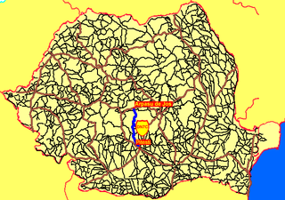
The Transfăgărășan or DN7C is a paved mountain road crossing the southern section of the Carpathian Mountains of Romania. It has national-road ranking and is the second-highest paved road in the country after the Transalpina. It starts near the village of Bascov, near Pitești, and stretches 90 kilometres (56 mi) to the crossroad between the DN1 and Sibiu, between the highest peaks in the country, Moldoveanu and Negoiu. The road, built in the early 1970s as a strategic military route, connects the historic regions of Transylvania and Wallachia.

The A689 is a road in northern England that runs east from the A595, 3.1 miles (5.0 km) to the west of Carlisle in Cumbria, to Hartlepool in County Durham.
The Flüela Pass is a high mountain pass of the Swiss Alps in Graubünden. Traditionally considered the boundary between the Albula and Silvretta Alps, the pass crosses the watershed / drainage divide between the basins of the Rivers Rhine and Danube. The pass is overlooked by the Flüela Schwarzhorn and the Flüela Wisshorn. The summit of the pass lies between the lakes Lai da la Scotta and Lai Nair.

Manyara Region is one of Tanzania's 31 administrative regions. The regional capital is the town of Babati. According to the 2012 national census, the region had a population of 1,425,131, which was lower than the pre-census projection of 1,497,555. For 2002-2012, the region's 3.2 percent average annual population growth rate was tied for the third highest in the country. It was also the 22nd most densely populated region with 32 people per square kilometre.
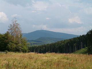
Kékes[ˈkeːkɛʃ] is Hungary's highest mountain, at 1,014 metres (3,327 ft) above sea level. It lies 12 kilometres (7.5 mi) northeast of Gyöngyös, in the Mátra range of Heves county. It is Hungary's third most popular tourist attraction, after Lake Balaton and the Danube, and has a number of hotels and skiing pistes. The Kékestető TV Tower stands at the summit.

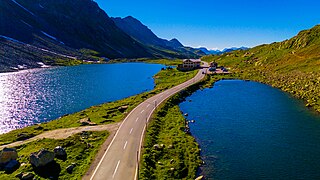
Taglang La or Tanglang La, elevation 5,328 metres (17,480 ft), is a high altitude mountain pass in the Indian union territory of Ladakh. As of September 2018, the Leh–Manali Highway leading south from Upshi to Tanglang La is paved, with the exception of a very short unpaved section just north of the pass. The pass itself is paved. On ascending the pass from the Moore plains the road is well paved with occasional streams crossing.
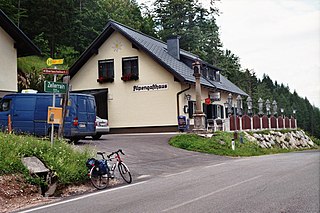
Zellerrain Pass is a mountain pass in the Ybbstal Alps, located on border between Lower Austria and Styria, west of Mariazell. The pass road has a steep grade of up to 22 percent. The river Ybbs has its source at the pass.

The Cairnwell Pass is a mountain pass on the A93 road between Glen Shee, Perthshire, and Braemar, Aberdeenshire, in the Scottish Highlands. The border between the two counties crosses the summit of the pass. With a summit altitude of 670 m (2199 ft), the Cairnwell Pass is the highest main road in the United Kingdom, and at the summit is the Glenshee Ski Centre, Scotland's largest and oldest ski centre. Historically, the pass was a drover's route from the Lowlands to the Highlands. The road is often blocked by snow in the winter, with snow gates at Braemar, at the summit, and at the Spittal of Glenshee.
European route E 62 is a road in Europe, part of the United Nations International E-road network. Approximately 1,307 kilometers (812 mi) long, it connects the French Atlantic port city of Nantes to Genoa, largest of Italy's port cities. Between France and Italy it also passes through Switzerland, via Geneva and Lausanne. After crossing into Italy, the E 62 passes Milan, Italy's largest commercial and industrial centre, before descending to Genoa on the Mediterranean coast.

Veleta or Pico del Veleta is the second highest peak of the Iberian peninsula and the Sierra Nevada. Its height is given variously as 3,394 metres (11,135 ft), 3,396 metres (11,142 ft) and 3,398 metres (11,148 ft).

The evolution of motorways construction in European Union member states by total number of kilometres existing in that year. This is a list of the total number of Motorways by country, member of the European Union. It includes motorways, classified as such by the Eurostat.
References
- Ordnance Survey maps, 1:25000 and 1:50000
- Climbbybike.com
- Cols d'Ecosse