Listed buildings in Chellaston

Last updated

Chellaston is an electoral ward in the city of Derby, England. The ward contains seven listed buildings that are recorded in the National Heritage List for England. Of these, one is listed at Grade II*, the middle of the three grades, and the others are at Grade II, the lowest grade. The ward contains a suburban village to the south of the city centre, and it is mainly residential. The listed buildings consist of a church, houses and a cottage, a farmhouse and farm buildings, and a war memorial.

Contents

Key

Map all coordinates using: OpenStreetMap  
Download coordinates as: KML
GradeCriteria< [1]
II*Particularly important buildings of more than special interest.
IIBuildings of national importance and special interest.

Buildings

Name and locationPhotographDateNotesGrade
St Peter's Church
52°52′10″N1°26′07″W / 52.86958°N 1.43522°W
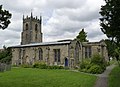
 / 52.86958; -1.43522 (St Peter's Church)
St Peter's Church, Chellaston - geograph.org.uk - 3642298.jpg
13th or early 14th centuryThe church has been altered and extended through the centuries, the tower was rebuilt in 1842, and the church was restored in 1884. It is built in stone with a slate roof, and consists of a nave, a south aisle, a chancel and a west tower. The tower has angle buttresses, a west doorway with a clock face above, single-light bell openings, and an embattled parapet with corner and central pinnacles. The chancel is in Perpendicular style. [2] [3] II*
4 Swarkestone Road
52°52′06″N1°26′18″W / 52.86837°N 1.43846°W / 52.86837; -1.43846 (4 Swarkestone Road)
The Corner Pin public house, Chellaston (cropped).jpg
16th century (probable)A timber framed house that has been much altered, the front in painted brick and with modillion eaves and tile roof. There are two storeys and a single bay. In thee ground floor is a doorway and a sash window to the right, and the upper floor contains a casement window. In the left gable end is exposed timber framing, including a cruck, and there is also exposed timber framing inside. [4] [5] II
White House Farmhouse
52°52′12″N1°26′00″W / 52.86988°N 1.43339°W / 52.86988; -1.43339 (White House Farmhouse)
Early 18th centuryThe farmhouse is in painted red brick, with bracketed wood eaves and a slate roof. There are two storeys and three bays. The central doorway has a moulded surround, a rectangular fanlight and a canopy, and the windows are sashes. [6] II
Loose boxes and barn,
White House Farm
52°52′12″N1°25′58″W / 52.86990°N 1.43272°W / 52.86990; -1.43272 (Loose boxes and barn, White House Farm)
18th century (probable)The farm buildings are in red brick with tile roofs. There are two storeys and an L-shaped plan, with two ranges at right angles. [7] II
Pear Tree Cottage
52°52′13″N1°26′23″W / 52.87034°N 1.43972°W / 52.87034; -1.43972 (Pear Tree Cottage)
1799The cottage is in colourwashed brick, with two storeys and two bays. The central doorway has reeded pilasters and a small cornice hood. The windows are sashes with channelled lintels, and between the upper floor windows is an oval tablet with the name of the cottage and the date. [8] II
1a Green Avenue
52°52′12″N1°26′05″W / 52.86987°N 1.43459°W / 52.86987; -1.43459 (1a Green Avenue)
1A Green Avenue with 84 High Street, Chellaston - geograph.org.uk - 3642307.jpg
Early 19th centuryA house and a shop on a corner site, later combined, the building is in painted brick with a dog-tooth string course between the storeys, and modillion eaves. There are two storeys, three bays on High Street, one on Green Avenue, and an angled corner between. In the corner is a doorway with a cambered head, and on each side is a shop window. On High Street is another doorway with a cambered head, and the other windows are casements, those in the ground floor with cambered heads. [9] II
Allenton war memorial
52°53′02″N1°26′57″W / 52.88383°N 1.44924°W / 52.88383; -1.44924 (Allenton war memorial)
Allenton War Memorial - geograph.org.uk - 3645018.jpg
1919The war memorial is in Hopton Wood limestone, and consists of the statue of a soldier in uniform with a rifle standing in front of a rock. The statue is on a pedestal on a moulded plinth on a base of one step. The plinth has a moulded capstone and a dentilled cornice, and contains panels with pointed heads. In the panels are inscriptions and the names of those who were lost, and those who were enlisted and returned from service in the First World War. [10] II

Related Research Articles

Alderwasley is a civil parish in the Amber Valley district of Derbyshire, England. The parish contains 16 listed buildings that are recorded in the National Heritage List for England. All the listed buildings are designated at Grade II, the lowest of the three grades, which is applied to "buildings of national importance and special interest". The parish contains the village of Alderwasley and the surrounding countryside. The listed buildings consist of houses and associated structures, farmhouses, a country house converted into a school, a church and a former chapel, a public house, a road bridge, a milestone, a former toll house, and a war memorial.

Ironville and Riddings is a ward in the Amber Valley district of Derbyshire, England. The ward contains 15 listed buildings that are recorded in the National Heritage List for England. Of these, one is listed at Grade II*, the middle of the three grades, and the others are at Grade II, the lowest grade. The ward contains the village of Riddings, part of the model village of Ironville, and the surrounding area. In Riddings was a model farm, and buildings forming part of this are listed. Other listed buildings include a church, houses, farmhouses and associated structures, public houses, and workers' cottages along the Cromford Canal.

Barrow upon Trent is a civil parish in the South Derbyshire district of Derbyshire, England. The parish contains twelve listed buildings that are recorded in the National Heritage List for England. Of these, one is listed at Grade I, the highest of the three grades, and the others are at Grade II, the lowest grade. The parish contains the villages of Barrow upon Trent and Arleston and the surrounding countryside, and is mainly rural. The listed buildings include houses, two churches, a farmhouse, a bridge over the Trent and Mersey Canal, a former school, and a war memorial.

Bretby is a civil parish in the South Derbyshire district of Derbyshire, England. The parish contains 13 listed buildings that are recorded in the National Heritage List for England. Of these, two are listed at Grade II*, the middle of the three grades, and the others are at Grade II, the lowest grade. The parish contains the village of Bretby and the surrounding countryside. The listed buildings include houses, cottages and associated structures, a farmhouse and farm buildings, a church, a former school, a former watermill, a bottle kiln and factory, a war memorial and village pump, and a telephone kiosk.

Charlesworth is a civil parish in the High Peak district of Derbyshire, England. The parish contains 15 listed buildings that are recorded in the National Heritage List for England. All the listed buildings are designated at Grade II, the lowest of the three grades, which is applied to "buildings of national importance and special interest". The parish contains the village of Charlesworth and the surrounding countryside. Most of the listed buildings are houses and cottages, farmhouses and farm buildings. The other listed buildings are a bridge, a church, a chapel and its associated walls, and a war memorial.

Crich is a civil parish in the Amber Valley district of Derbyshire, England. The parish contains 52 listed buildings that are recorded in the National Heritage List for England. Of these, one is listed at Grade I, the highest of the three grades, one is at Grade II*, the middle grade, and the others are at Grade II, the lowest grade. The parish contains the villages of Crich, Fritchley, Whatstandwell, and Wheatcroft, and the surrounding countryside. Most of the listed buildings are houses, cottages and associated structures, farmhouses and farm buildings. In the parish is the National Tramway Museum, and a number of structures that have been moved from other sites to the museum are listed. The other listed buildings include churches and chapels, a bridge over the Cromford Canal and a road bridge over the River Derwent, public houses, buildings associated with tramways, a milepost, a village cross, a memorial tower, and a village telephone kiosk.

Cubley is a civil parish in the Derbyshire Dales district of Derbyshire, England. The parish contains twelve listed buildings that are recorded in the National Heritage List for England. Of these, one is listed at Grade I, the highest of the three grades, and the others are at Grade II, the lowest grade. The parish contains the settlements of Great Cubley and Little Cubley, and the surrounding countryside. The listed buildings consist of houses, cottages and associated structures, a church and memorials in the churchyard, farmhouses, and a village pump.

Hognaston is a civil parish in the Derbyshire Dales district of Derbyshire, England. The parish contains nine listed buildings that are recorded in the National Heritage List for England. Of these, one listed at Grade II*, the middle of the three grades, and the others are at Grade II, the lowest grade. The parish contains the village of Hognaston and the surrounding area. The listed buildings consist of houses, cottages, farmhouses, a church, and a telephone kiosk.

Holbrook is a civil parish in the Amber Valley district of Derbyshire, England. The parish contains 14 listed buildings that are recorded in the National Heritage List for England. Of these, one is listed at Grade II*, the middle of the three grades, and the others are at Grade II, the lowest grade. The parish contains the village of Holbrook, the hamlet of Coxbench, and the surrounding area. Most of the listed buildings are houses, cottages and associated structures, farmhouses and farm buildings. The other listed buildings include a church and associated structures, and two former stocking frame knitter's workshops.

Swadlincote is a town in the South Derbyshire district of Derbyshire, England. It contains 24 listed buildings that are recorded in the National Heritage List for England. Of these, two are at Grade II*, the middle of the three grades, and the others are at Grade II, the lowest grade. The list contains the listed buildings in the town, and also those in the village of Church Gresley, the wards of Midway, and Newhall and Stanton, and part of the ward of Woodville. The listed buildings include houses and associated structures, farmhouses, churches, former industrial buildings including bottle kilns, a town hall, a showroom and a school.

Stanton by Dale is a civil parish in the Borough of Erewash in Derbyshire, England. The parish contains ten listed buildings that are recorded in the National Heritage List for England. Of these, one is listed at Grade II*, the middle of the three grades, and the others are at Grade II, the lowest grade. The parish contains the village of Stanton by Dale and the surrounding area, and the listed buildings consist of a country house, a farmhouse, smaller houses and cottages, a row of almshouses, a church with a war memorial in the churchyard, a village cross and a village pump.

Trusley is a civil parish in the South Derbyshire district of Derbyshire, England. The parish contains eight listed buildings that are recorded in the National Heritage List for England. Of these, one is listed at Grade II*, the middle of the three grades, and the others are at Grade II, the lowest grade. The parish contains the villages of Trusley and Longlane, and the surrounding countryside. The listed buildings include houses and cottages, two churches, and a muniment room converted from a summer house.

Weston Underwood is a civil parish in the Amber Valley district of Derbyshire, England. The parish contains 16 listed buildings that are recorded in the National Heritage List for England. Of these, two are listed at Grade I, the highest of the three grades, one is at Grade II*, the middle grade, and the others are at Grade II, the lowest grade. The parish contains the villages of Weston Underwood and Mugginton and the surrounding area, including part of Kedleston Park. The listed buildings in the park are a bridge and a cascade, a Gothic temple, and a sawmill and engine houses. Elsewhere, they include houses, cottages and associated structures, farmhouses and farm buildings, a church and two mileposts.

Wormhill is a civil parish in the High Peak district of Derbyshire, England. The parish contains 26 listed buildings that are recorded in the National Heritage List for England. Of these, three are listed at Grade II*, the middle of the three grades, and the others are at Grade II, the lowest grade. The parish contains the village of Wormhill and the surrounding area. Most of the listed buildings are houses, cottages and associated structures, farmhouses and farm buildings. The other listed buildings include a church and associated structures, a village cross moved into the churchyard, a railway viaduct, and a memorial fountain.

Yeaveley is a civil parish in the Derbyshire Dales district of Derbyshire, England. The parish contains nine listed buildings that are recorded in the National Heritage List for England. Of these, one is listed at Grade I, the highest of the three grades, one is at Grade II*, the middle grade, and the others are at Grade II, the lowest grade. The parish contains the village of Yeaveley and the surrounding countryside. The oldest listed building in the parish consists of the remains of a preceptory of the Knights Hospitaller. The other listed buildings are houses and associated structures, farmhouses and farm buildings, and a church.

Yeldersley is a civil parish in the Derbyshire Dales district of Derbyshire, England. The parish contains 14 listed buildings that are recorded in the National Heritage List for England. All the listed buildings are designated at Grade II, the lowest of the three grades, which is applied to "buildings of national importance and special interest". The parish is almost entirely rural, with no substantial settlements, and the listed buildings consist of houses, cottages and associated structures, farmhouses and farm buildings, and a milepost.

Youlgreave is a civil parish in the Derbyshire Dales district of Derbyshire, England. The parish contains 57 listed buildings that are recorded in the National Heritage List for England. Of these, one is listed at Grade I, the highest of the three grades, one is at Grade II*, the middle grade, and the others are at Grade II, the lowest grade. The parish contains the village of Youlgreave, the hamlet of Alport and the surrounding countryside. Most of the listed buildings are houses, cottages and associated structures, farmhouses and farm buildings. The other listed buildings include a church and associated structures, a public house, bridges, a milestone, a conduit head, a school, a youth hostel and a telephone kiosk.

Abbey is an electoral ward in the city of Derby, England. The ward contains 15 listed buildings that are recorded in the National Heritage List for England. Of these, one is listed at Grade II*, the middle of the three grades, and the others are at Grade II, the lowest grade. The ward, which is to the west of the city centre, is mainly residential. The listed buildings include a public house, a former toll house, private houses later used for other purposes, the lodge to a cemetery and three memorials in the cemetery, a former training college, former barracks, a church and associated structures, and an engine house and a warehouse built by the Great Northern Railway.

Alvaston is an electoral ward in the city of Derby, England. The ward contains 14 listed buildings that are recorded in the National Heritage List for England. Of these, three are listed at Grade II*, the middle of the three grades, and the others are at Grade II, the lowest grade. The ward was initially a village, and it has grown to become a suburb of the city. Towards the north of the ward are the former Tri Junct Station and the Derby Railway Works, and associated with them are four listed buildings. Some of the oldest listed buildings, consisting of cottages and a farmhouse, are located near the original centre of the village. The other listed buildings include churches and associated structures, a former toll house, and a conference centre.

Chaddesden is an electoral ward in the city of Derby, England. The ward contains three listed buildings that are recorded in the National Heritage List for England. Of these, one is listed at Grade I, the highest of the three grades, and the others are at Grade II, the lowest grade. The ward is a suburb to the east of the centre of the city and is largely residential. The listed buildings consist of a church, a cottage and a war memorial.

References

Citations

Sources

  • Historic England, "Church of St Peter, Chellaston (1227902)", National Heritage List for England , retrieved 22 January 2023
  • Historic England, "4 Swarkestone Road, Chellaston (1229612)", National Heritage List for England, retrieved 22 January 2023
  • Historic England, "White House Farmhouse, Chellaston (1227838)", National Heritage List for England, retrieved 22 January 2023
  • Historic England, "A Range of Loose Boxes to east of White House Farmhouse with Barn (now partly demolished) on return side in Aston Lane, Chellaston (1287488)", National Heritage List for England, retrieved 22 January 2023
  • Historic England, "Pear Tree Cottage, Chellaston (1216179)", National Heritage List for England, retrieved 22 January 2023
  • Historic England, "1A Green Avenue, Chellaston (1287446)", National Heritage List for England, retrieved 22 January 2023
  • Historic England, "Allenton War Memorial, Chellaston (1431002)", National Heritage List for England, retrieved 22 January 2023
  • Hartwell, Clare; Pevsner, Nikolaus; Williamson, Elizabeth (2016) [1978]. Derbyshire. The Buildings of England. New Haven and London: Yale University Press. ISBN   978-0-300-21559-5.
  • Historic England, Listed Buildings , retrieved 22 January 2023