Listed buildings in Clowne

Last updated

Clowne is a civil parish in the Bolsover District of Derbyshire, England. The parish contains nine listed buildings that are recorded in the National Heritage List for England. Of these, two are listed at Grade II*, the middle of the three grades, and the others are at Grade II, the lowest grade. The parish contains the town of Clowne and the surrounding area. The listed buildings consist of houses and associated structures, the ruins of a former country house, a church, a market cross, and a war memorial.

Contents

Key

Map all coordinates using: OpenStreetMap  
Download coordinates as: KML
GradeCriteria [1]
II*Particularly important buildings of more than special interest
IIBuildings of national importance and special interest

Buildings

Name and locationPhotographDateNotesGrade
Church of St John the Baptist
53°16′20″N1°15′16″W / 53.27230°N 1.25438°W
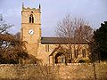
 / 53.27230; -1.25438 (Church of St John the Baptist)
St John the Baptist Church, Clowne.jpg
12th centuryThe church has been altered and extended through the centuries, and in 1954–55 the chancel was extended and a chapel added. It is built in limestone with slate roofs, and consists of a nave with a south porch, a chancel with a south chapel, and a west tower. The tower has two unequal stages, a chamfered plinth, diagonal buttresses, a west doorway with an almost round arch, above which is a three-light Perpendicular window, a chamfered string course, two-light bell openings, and an embattled parapet with corner crocketed pinnacles. The north wall is pebbledashed and supported by two large buttresses, and the south doorway is in Norman style. [2] [3] II*
Clowne Cross
53°16′25″N1°15′52″W / 53.27367°N 1.26445°W
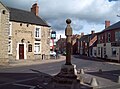
 / 53.27367; -1.26445 (Clowne Cross)
Clowne Market Cross.jpg
14th century (probable)The market cross stands in the middle of a road junction, and is in sandstone. The oldest parts are the base and the steps, with the upper parts dating from the late 17th century. It has three polygonal steps and a square base with broached and chamfered corners. On this is a circular column surmounted by a square cube acting as a sundial, and a ball finial. [2] [4] II*
Ruins of Romiley Hall
53°16′06″N1°17′35″W / 53.26844°N 1.29313°W / 53.26844; -1.29313 (Ruins of Romiley Hall)
Early 17th centuryThe ruins of a small country house are in sandstone, and without a roof. There is now a single storey, and it contains a doorway with a chamfered surround, and the remains of mullioned and transomed windows. [5] II
Manor Farmhouse and barn
53°16′49″N1°15′31″W / 53.28037°N 1.25874°W / 53.28037; -1.25874 (Manor Farmhouse and barn)
17th centuryThe farmhouse and barn are in limestone with sandstone dressings and quoins. The farmhouse has a tile roof, two storeys and four bays. On the front is a doorway with a lean-to porch, and the windows are a mix of sashes and casements, some with hood moulds. Recessed on the left is the barn, with a corrugated asbestos roof, two doorways, and mullioned windows. [6] II
Barn southeast of 106 High Street
53°16′22″N1°16′09″W / 53.27283°N 1.26921°W / 53.27283; -1.26921 (Barn southeast of 106 High Street)
18th centuryThe barn is in limestone with sandstone dressings, and a pantile roof with the remains of coped gables and plain kneelers. There is a single storey, and the openings include a central cart entrance with a timber lintel and doorways. [7] II
106 High Street
53°16′23″N1°16′10″W / 53.27303°N 1.26943°W / 53.27303; -1.26943 (106 High Street)
1758A farmhouse in limestone with sandstone dressings, quoins, and a tile roof with coped gables and plain kneelers. There are two storeys and attics, and three bays. The doorway has a massive lintel and jambs, and to its left is a stair window. In the outer bays are two-light mullioned windows, and on the front of the house is an initialled datestone. [8] II
Southgate House
53°17′19″N1°15′15″W / 53.28864°N 1.25420°W / 53.28864; -1.25420 (Southgate House)
Van Dyk Hotel - geograph.org.uk - 814779.jpg
Late 18th centuryA small country house converted into a hotel, it is rendered, on a plinth, and has painted stone dressings, quoins, floor bands, and a hipped Welsh slate roof. There are three storeys and a symmetrical front of three bays, the middle bay projecting under a pediment. In the centre is a doorway with a round-arched fanlight and side lights, above it is a Venetian window, and in the top floor is a tripartite window, the middle light with a segmental head. The other windows are sashes with keystones. [2] [9] II
Southgate Stables and wall
53°17′21″N1°15′11″W / 53.28913°N 1.25298°W / 53.28913; -1.25298 (Southgate Stables and wall)
Mid 18th centuryA pair of cottages, stables, and a coach house in sandstone with quoins, and Welsh slate roofs with coped gables and moulded kneelers. They have one and two storeys and form a U-shaped plan, with a central range and two projecting wings. In the central range is a square tower, with a doorway over which is a circular window, a blind rectangular window, and a pyramidal roof. To the right are two segmental-arched carriage entrances. The right wing has four bays and it contains the cottages. The courtyard is enclosed by a wall with rounded copings. [10] [11] II
War memorial
53°16′31″N1°15′47″W / 53.27519°N 1.26301°W / 53.27519; -1.26301 (War memorial)
Clowne war memorial,circa 1970 - panoramio.jpg
c. 1920The war memorial is in Portland stone, and consists of a life-size sculpture of a soldier in uniform. This stands on a tall tapering square pier with a moulded top, on a square base and a plinth. On the pier are the names of those lost in the two World Wars. [2] [12] II

Related Research Articles

Ault Hucknall is a civil parish in the Bolsover district of Derbyshire, England. The parish contains 23 listed buildings that are recorded in the National Heritage List for England. Of these, three are listed at Grade I, the highest of the three grades, one is at Grade II*, the middle grade, and the others are at Grade II, the lowest grade. The parish contains the village of Ault Hucknall and the surrounding area, including the settlements of Astwith, Hardstoft, and Rowthorne. The most important buildings in the parish are Hardwick Hall and its predecessor Hardwick Old Hall, which are listed together with associated structures in the grounds and surrounding parkland. The other listed buildings include a church and a chest tomb in the churchyard, houses and farmhouses, a public house, a watermill, a former Sunday school, and a war memorial.

Bamford is a civil parish in the High Peak district of Derbyshire, England. The parish contains eight listed buildings that are recorded in the National Heritage List for England. Of these, one is listed at Grade II*, the middle of the three grades, and the others are at Grade II, the lowest grade. The parish contains the village of Bamford, and is otherwise rural. The listed buildings consist of a farmhouse and two associated barns, a bridge, and two churches with associated structures.

Barlborough is a civil parish in the Bolsover district of Derbyshire, England. The parish contains 29 listed buildings that are recorded in the National Heritage List for England. Of these, one is listed at Grade I, the highest of the three grades, six are at Grade II*, the middle grade, and the others are at Grade II, the lowest grade. The parish contains the village of Barlborough and the surrounding area. The listed buildings include two country houses, smaller houses and associated structures, a church, a village cross, farmhouses and farm buildings, a former almshouse, two monuments in a garden, the walls of a burial ground, a memorial gateway, and a school.

Barlow is a civil parish in the North East Derbyshire district of Derbyshire, England. The parish contains 18 listed buildings that are recorded in the National Heritage List for England. Of these, three are listed at Grade II*, the middle of the three grades, and the others are at Grade II, the lowest grade. The parish contains the village of Burton and the surrounding countryside, mainly to the west of the village. It is almost entirely rural, and the listed buildings are mainly houses and associated structures, farmhouses and farm buildings. The other listed buildings are a church, its former rectory, a bridge, a former school, a pinfold, and a village pump.

Barton Blount is a civil parish in the South Derbyshire district of Derbyshire, England. The parish contains seven listed buildings that are recorded in the National Heritage List for England. Of these, one is listed at Grade II*, the middle of the three grades, and the others are at Grade II, the lowest grade. The parish contains the small village of Barton Blount and is otherwise rural. The most important building in the parish is Barton Hall, which is listed, together with associated buildings, including a chapel. The other listed buildings are farmhouses and outbuildings.

Beeley is a civil parish in the Derbyshire Dales district of Derbyshire, England. The parish contains 20 listed buildings that are recorded in the National Heritage List for England. Of these, three are listed at Grade II*, the middle of the three grades, and the others are at Grade II, the lowest grade. The parish contains the village of Beeley and the surrounding countryside and moorland, mainly to the east of the village. Most of the listed buildings are houses, cottages, and associated structures. The other listed buildings include a church, a public house, a guide post and guide stone, a farmhouse, a converted barn, a former school, and a former vicarage.

Brackenfield is a civil parish in the North East Derbyshire district of Derbyshire, England. The parish contains 15 listed buildings that are recorded in the National Heritage List for England. Of these, one is listed at Grade II*, the middle of the three grades, and the others are at Grade II, the lowest grade. The parish contains the village of Brackenfield and the surrounding area. The most important building in the parish is Ogston Hall, a country house, that is listed together with associated structures. The other listed buildings are farmhouses and farm buildings, a church and its lychgate, a ruined chapel, a public house, a wall containing a gravestone and a guidepost, and a railway bridge.

Brailsford is a civil parish in the Derbyshire Dales district of Derbyshire, England. The parish contains 35 listed buildings that are recorded in the National Heritage List for England. Of these, one is listed at Grade I, the highest of the three grades, and the others are at Grade II, the lowest grade. The parish contains the village of Brailsford and the hamlet of Ednaston, and the surrounding countryside. Most of the listed buildings are houses, cottages and associated structures, farmhouses and farm buildings. The other listed buildings include a church, a churchyard cross, a watermill, two boundary posts, two mileposts, a bridge, a school, and a well.

Bretby is a civil parish in the South Derbyshire district of Derbyshire, England. The parish contains 13 listed buildings that are recorded in the National Heritage List for England. Of these, two are listed at Grade II*, the middle of the three grades, and the others are at Grade II, the lowest grade. The parish contains the village of Bretby and the surrounding countryside. The listed buildings include houses, cottages and associated structures, a farmhouse and farm buildings, a church, a former school, a former watermill, a bottle kiln and factory, a war memorial and village pump, and a telephone kiosk.

Calke is a civil parish in the South Derbyshire district of Derbyshire, England. The parish contains 20 listed buildings that are recorded in the National Heritage List for England. Of these, one is listed at Grade I, the highest of the three grades, two are at Grade II*, the middle grade, and the others are at Grade II, the lowest grade. The parish contains the village of Calke, but is largely occupied by the country house, Calke Abbey, and its grounds. The house is listed, as are associated buildings, and structures in the grounds, including a church, an orangery, deer shelters, and an entrance lodge. The other listed building is a house in the village.

Callow is a civil parish in the Derbyshire Dales district of Derbyshire, England. The parish contains six listed buildings that are recorded in the National Heritage List for England. Of these, one is listed at Grade II*, the middle of the three grades, and the others are at Grade II, the lowest grade. The parish is almost entirely rural, and all the listed buildings are farmhouses or farm buildings.

Castleton is a civil parish in the High Peak district of Derbyshire, England. The parish contains 25 listed buildings that are recorded in the National Heritage List for England. Of these, one is listed at Grade I, the highest of the three grades, one is at Grade II*, the middle grade, and the others are at Grade II, the lowest grade. The parish contains the village of Castleton and the surrounding countryside and moorland. The most important building in the parish is the ruined Peveril Castle, which is listed at Grade I. The other listed buildings include houses, cottages and associated structures, farmhouses and farm buildings, a church and a sundial in the churchyard, a hotel and a public house, a former watermill, three mileposts, a school, a war memorial, and a telephone kiosk.

Charlesworth is a civil parish in the High Peak district of Derbyshire, England. The parish contains 15 listed buildings that are recorded in the National Heritage List for England. All the listed buildings are designated at Grade II, the lowest of the three grades, which is applied to "buildings of national importance and special interest". The parish contains the village of Charlesworth and the surrounding countryside. Most of the listed buildings are houses and cottages, farmhouses and farm buildings. The other listed buildings are a bridge, a church, a chapel and its associated walls, and a war memorial.

Chelmorton is a civil parish in the Derbyshire Dales district of Derbyshire, England. The parish contains four listed buildings that are recorded in the National Heritage List for England. Of these, one is listed at Grade II*, the middle of the three grades, and the others are at Grade II, the lowest grade. The parish contains the village of Chelmorton and the surrounding area, and the listed buildings consist of a church, a cross in the churchyard, a farmhouse, and a barn.

Chinley, Buxworth and Brownside is a civil parish in the High Peak district of Derbyshire, England. The parish contains 29 listed buildings that are recorded in the National Heritage List for England. Of these, one is listed at Grade II*, the middle of the three grades, and the others are at Grade II, the lowest grade. The parish contains settlements, including the villages of Chinley and Buxworth, and is otherwise rural. Most of the listed buildings are farmhouses and farm buildings, houses, cottages and associated structures. The Peak Forest Canal ends in the parish at Bugsworth Basin, and two listed buildings are associated with it. The other listed buildings consist of a church and two chapels, and a pair of railway viaducts.

Chisworth is a civil parish in the High Peak district of Derbyshire, England. The parish contains six listed buildings that are recorded in the National Heritage List for England. All the listed buildings are designated at Grade II, the lowest of the three grades, which is applied to "buildings of national importance and special interest". The parish contains the small settlements of Chisworth and Higher Chisworth, and is otherwise rural. The listed buildings consist of four farmhouses, a house, and a barn.

Clay Cross is a civil parish in the North East Derbyshire district of Derbyshire, England. The parish contains 13 listed buildings that are recorded in the National Heritage List for England. All the listed buildings are designated at Grade II, the lowest of the three grades, which is applied to "buildings of national importance and special interest". The parish contains the town of Clay Cross and the surrounding area. The listed buildings consist of houses, cottages and associated structures, a church, a milepost, the portals of a railway tunnel, items in a cemetery, and a war memorial.

Clifton and Compton is a civil parish in the Derbyshire Dales district of Derbyshire, England. The parish contains eight listed buildings that are recorded in the National Heritage List for England. Of these, one is listed at Grade II*, the middle of the three grades, and the others are at Grade II, the lowest grade. The parish contains the villages of Clifton and Hangingbridge, and the surrounding area. The listed buildings consist of houses, cottages and associated structures, a church, its lychgate and wall, a road bridge, and a public house.

Codnor is a civil parish in the Amber Valley district of Derbyshire, England. The parish contains three listed buildings that are recorded in the National Heritage List for England. All the listed buildings are designated at Grade II, the lowest of the three grades, which is applied to "buildings of national importance and special interest". The parish contains the village of Codnor, the hamlet of Cross Hill, and the surrounding area. The listed buildings consist of a house, a farmhouse, and a church.

Crich is a civil parish in the Amber Valley district of Derbyshire, England. The parish contains 52 listed buildings that are recorded in the National Heritage List for England. Of these, one is listed at Grade I, the highest of the three grades, one is at Grade II*, the middle grade, and the others are at Grade II, the lowest grade. The parish contains the villages of Crich, Fritchley, Whatstandwell, and Wheatcroft, and the surrounding countryside. Most of the listed buildings are houses, cottages and associated structures, farmhouses and farm buildings. In the parish is the National Tramway Museum, and a number of structures that have been moved from other sites to the museum are listed. The other listed buildings include churches and chapels, a bridge over the Cromford Canal and a road bridge over the River Derwent, public houses, buildings associated with tramways, a milepost, a village cross, a memorial tower, and a village telephone kiosk.

References

Citations

Sources

  • Historic England, "Church of St John the Baptist, Clowne (1040039)", National Heritage List for England , retrieved 20 May 2022
  • Historic England, "Clowne Cross, Clowne (1108957)", National Heritage List for England, retrieved 20 May 2022
  • Historic England, "Ruins of Romiley Hall, Clowne (1045913)", National Heritage List for England, retrieved 20 May 2022
  • Historic England, "Manor Farmhouse and attached Barn, Clowne (1040017)", National Heritage List for England, retrieved 20 May 2022
  • Historic England, "Barn to the south east of No. 106 High Street, Clowne (1108958)", National Heritage List for England, retrieved 20 May 2022
  • Historic England, "No. 106 High Street, Clowne (1045910)", National Heritage List for England, retrieved 20 May 2022
  • Historic England, "Southgate House, Clowne (1108959)", National Heritage List for England, retrieved 20 May 2022
  • Historic England, "Southgate Stables, including wall to south enclosing stable yard, Clowne (1045918)", National Heritage List for England, retrieved 20 May 2022
  • Historic England, "War Memorial, Clowne (1108956)", National Heritage List for England, retrieved 20 May 2022
  • Hartwell, Clare; Pevsner, Nikolaus; Williamson, Elizabeth (2016) [1978]. Derbyshire. The Buildings of England. New Haven and London: Yale University Press. ISBN   978-0-300-21559-5.
  • Historic England, Listed Buildings , retrieved 20 May 2022