Kirkburton is a civil parish in the metropolitan borough of Kirklees, West Yorkshire, England. It contains 164 listed buildings that are recorded in the National Heritage List for England. Of these, two are listed at Grade I, the highest of the three grades, two are at Grade II*, the middle grade, and the others are at Grade II, the lowest grade. The list also includes two listed buildings outside the parish but in Kirkburton ward; both of these are at Grade II. There are no major towns in the parish, but it contains villages and smaller settlements including Farnley Tyas, Flockton, Flockton Green, Grange Moor, Highburton, Kirkheaton, Lepton, Shelley, Shepley, Stocksmoor, Thunder Bridge, and Thurstonland. The parish is otherwise rural.
Northowram is in the ward of Northowram and Shelf in the metropolitan borough of Calderdale, West Yorkshire, England. It contains 32 listed buildings that are recorded in the National Heritage List for England. Of these, five are at Grade II*, the middle of the three grades, and the others are at Grade II, the lowest grade. The ward contains the village of Northowram, and areas to the west extending to the eastern boundary of Halifax, and includes the settlements of Shibden, Stump Cross and Claremount. Most of the listed buildings are houses, cottages and associated structures, farmhouses, and farm buildings. The other listed buildings include churches, a public house, an underground bath house, a slab wall, a former textile mill converted into flats, and a boundary stone.
Shelf is in the ward of Northowram and Shelf in the metropolitan borough of Calderdale, West Yorkshire, England. It contains 28 listed buildings that are recorded in the National Heritage List for England. Of these, one is listed at Grade I, the highest of the three grades, two are at Grade II*, the middle grade, and the others are at Grade II, the lowest grade. The ward contains the village of Shelf and the surrounding area. Most of the listed buildings are houses, cottages and associated structures, farmhouses, and farm buildings. The other listed buildings include a guide post, a public house, a church, two boundary stones, a milestone, a set of stocks, and the archway to a former brewery.
Crigglestone is a civil parish in the metropolitan borough of the City of Wakefield, West Yorkshire, England. The parish contains 20 listed buildings that are recorded in the National Heritage List for England. Of these, one is listed at Grade II*, the middle of the three grades, and the others are at Grade II, the lowest grade. The parish is mainly residential, and most of the listed buildings are houses, farmhouses and farm buildings. The other listed buildings consist of two churches, a former corn mill, and a milestone.
Monk Bretton is a ward in the metropolitan borough of Barnsley, South Yorkshire, England. The ward contains 14 listed buildings that are recorded in the National Heritage List for England. Of these, three are listed at Grade I, the highest of the three grades, and the others are at Grade II, the lowest grade. The ward contains the village of Monk Bretton and the surrounding area. In the ward are the remains of Monk Bretton Priory, its gatehouse and an administrative block, all, listed at Grade I. The other listed buildings are houses, farmhouses and farm buildings, a former water mill, a market cross, and a church.
Penistone is a civil parish in the metropolitan borough of Barnsley, South Yorkshire, England. The parish contains 82 listed buildings that are recorded in the National Heritage List for England. Of these, one is listed at Grade I, the highest of the three grades, three are at Grade II*, the middle grade, and the others are at Grade II, the lowest grade. The parish contains the town of Penistone, the villages of Cubley, Hoylandswaine, Millhouse Green, and Thurlstone, and the surrounding countryside. Most of the listed buildings are houses, cottages and associated structures, farmhouses and farm buildings. The other listed buildings include churches and a chapel, items in a churchyard, and a former vicarage, a wayside cross, a boundary marker, a guide stoup, milestones, bridges, a railway viaduct, a former cloth hall, a former bank, a former nail workshop, coal drops, a war memorial, and a telephone kiosk.
Royston is a ward in the metropolitan borough of Barnsley, South Yorkshire, England. The ward contains four listed buildings that are recorded in the National Heritage List for England. Of these, one is listed at Grade I, the highest of the three grades, and the others are at Grade II, the lowest grade. The ward contains the town of Royston, the village of Carlton, and the surrounding area. The listed buildings consist of two churches, a wayside cross, and a former farmhouse.
Tankersley is a civil parish in the metropolitan borough of Barnsley, South Yorkshire, England. The parish contains twelve listed buildings that are recorded in the National Heritage List for England. Of these, one is listed at Grade II*, the middle of the three grades, and the others are at Grade II, the lowest grade. The parish contains the villages of Tankersley and Pilley, and the surrounding area. The listed buildings consist of a church, a sundial and a mounting block in the churchyard, houses, farmhouses and farm buildings, a milepost, and a former coal mines rescue station.
Wortley is a civil parish in the metropolitan borough of Barnsley, South Yorkshire, England. The parish contains 25 listed buildings that are recorded in the National Heritage List for England. Of these, one is listed at Grade II*, the middle of the three grades, and the others are at Grade II, the lowest grade. The parish contains the village of Wortley and the surrounding countryside. In the parish is the country house, Wortley Hall, which is listed, together with associated structures and items in the gardens and grounds. The other listed buildings include houses and cottages, two cross bases, a church, a public house, a milestone, and three mileposts.
Adwick upon Dearne is a civil parish in the metropolitan borough of Doncaster, South Yorkshire, England. The parish contains seven listed buildings that are recorded in the National Heritage List for England. Of these, one is listed at Grade II*, the middle of the three grades, and the others are at Grade II, the lowest grade. The parish contains the village of Adwick upon Dearne and the surrounding countryside. The listed buildings consist of a church, a cross base in the churchyard, a dovecote, two bridges, and a farmhouse.
Bentley is a ward in the metropolitan borough of Doncaster, South Yorkshire, England. The ward contains 22 listed buildings that are recorded in the National Heritage List for England. Of these, one is listed at Grade I, the highest of the three grades, and the others are at Grade II, the lowest grade. The ward contains the suburb of Bentley, the villages of Almholme, Arksey, and Toll Bar, and the surrounding area. There is a group of listed buildings in Arksey, including the church, the vicarage, the former school and its wall, a group of almshouses, a hall, and a pinfold. Elsewhere, the listed buildings include another church, another pinfold, houses and cottages, a former watermill, farmhouses and farm buildings, a road causeway, a road bridge, and four mileposts.
Braithwell is a civil parish in the metropolitan borough of Doncaster, South Yorkshire, England. The ward contains 15 listed buildings that are recorded in the National Heritage List for England. Of these, one is listed at Grade II*, the middle of the three grades, and the others are at Grade II, the lowest grade. The parish contains the villages of Braithwell and Micklebring and the surrounding area. The listed buildings include houses and associated structures, the ruins of a medieval house, a church, memorials in the churchyard, a village cross, a milestone, and a war memorial.
Burghwallis is a civil parish in the metropolitan borough of Doncaster, South Yorkshire, England. The parish contains ten listed buildings that are recorded in the National Heritage List for England. Of these, one is listed at Grade I, the highest of the three grades, one is at Grade II*, the middle grade, and the others are at Grade II, the lowest grade. The parish contains the village of Burghwallis and the surrounding area. Most of the listed buildings are in the village, and consist of a church, the ruins of a cross and a gravestone in the churchyard, the former rectory, houses, a pinfold, and a war memorial, and outside the village are a well head and a mill building.
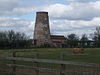
Norton is a civil parish, and Norton and Askern is a ward, in the metropolitan borough of Doncaster, South Yorkshire, England. The parish and ward contain 27 listed buildings that are recorded in the National Heritage List for England. Of these, two are listed at Grade I, the highest of the three grades, and the others are at Grade II, the lowest grade. The parish and ward contain the villages of Norton, Campsall, Skellow, and Sutton and the surrounding countryside. Most of the listed buildings are houses, cottages and associated structures, farmhouses and farm buildings. The other listed buildings include a church, three cross bases, two bridges, a former windmill, a former watermill, a public house, two mileposts, a former toll house, and a village pump.
Owston is a civil parish in the metropolitan borough of Doncaster, South Yorkshire, England. The parish contains 20 listed buildings that are recorded in the National Heritage List for England. Of these, one is listed at Grade I, the highest of the three grades, one is at Grade II*, the middle grade, and the others are at Grade II, the lowest grade. The parish contains the village of Owston and the surrounding countryside. The most important buildings in the parish are a church, which is listed together with the remains of a cross, and Owston Hall, also listed, together with associated structures. The other listed buildings consist of houses, cottages and associated structures, and farmhouses and farm buildings.
Sprotbrough and Cusworth is a civil parish in the metropolitan borough of Doncaster, South Yorkshire, England. The parish contains 21 listed buildings that are recorded in the National Heritage List for England. Of these, two are listed at Grade I, the highest of the three grades, and the others are at Grade II, the lowest grade. The parish contains the villages of Sprotbrough and Cusworth, and the surrounding countryside. In the parish is Cusworth Hall, which is listed together with associated structures in the grounds and in Cusworth Park. The other listed buildings include two churches, a cross base, a farmhouse converted into a public house, the remains of a pump house, houses and associated structures, a mounting block, a village pump, a former toll house, and a telephone kiosk.
Stainforth is a civil parish in the metropolitan borough of Doncaster, South Yorkshire, England. The parish contains 13 listed buildings that are recorded in the National Heritage List for England. All the listed buildings are designated at Grade II, the lowest of the three grades, which is applied to "buildings of national importance and special interest". The parish contains the town of Stainforth and the village of South Bramwith, and the surrounding area. The buildings include a small country house, which is listed together with associated structures. The other listed buildings include smaller houses and cottages, a farmhouse and farm buildings, a swing bridge, a war memorial, and two headstocks from a former colliery.
Sykehouse is a civil parish in the metropolitan borough of Doncaster, South Yorkshire, England. The parish contains eight listed buildings that are recorded in the National Heritage List for England. All the listed buildings are designated at Grade II, the lowest of the three grades, which is applied to "buildings of national importance and special interest". The parish contains the village of Sykehouse and the surrounding countryside. The listed buildings include farmhouses and farm buildings, a church and a cross base in the churchyard, a bridge, and a former windmill.
Maltby is a civil parish in the Metropolitan Borough of Rotherham, South Yorkshire, England. The parish contains 40 listed buildings that are recorded in the National Heritage List for England. Of these, one is listed at Grade I, the highest of the three grades, three are at Grade II*, the middle grade, and the others are at Grade II, the lowest grade. The parish contains the town of Maltby and a large area to the southeast of the town. This area includes the country house of Sandbeck Park, which is listed together with a number of associated buildings and structures. Also in the area is Roche Abbey, and items in its grounds are listed. The other listed buildings include houses and cottages, a church and a tomb in the churchyard, a market cross, former watermills, farmhouses and farm buildings, mileposts, and a war memorial.
Whiston is a civil parish in the Metropolitan Borough of Rotherham, South Yorkshire, England. The parish contains 18 listed buildings that are recorded in the National Heritage List for England. Of these, three are listed at Grade II*, the middle of the three grades, and the others are at Grade II, the lowest grade. The parish contains the villages of Whiston and Morthen and the surrounding countryside. Most of the listed buildings are houses and associated structures, farmhouses and farm buildings. The other listed buildings include a church, a headstone in the churchyard, a cross base, a set of stocks, and two mileposts.