Listed buildings in Shirley, Derbyshire

Last updated

Shirley is a civil parish in the Derbyshire Dales district of Derbyshire, England. The parish contains 16 listed buildings that are recorded in the National Heritage List for England. Of these, two are listed at Grade II*, the middle of the three grades, and the others are at Grade II, the lowest grade. The parish contains the village of Shirley and the surrounding countryside. Most of the listed buildings are houses, cottages and associated structures, farmhouses and farm buildings. The other listed buildings include a church, a cross in the churchyard, a public house, and a former saw mill with an adjacent shed.

Contents

Key

Map all coordinates using: OpenStreetMap  
Download coordinates as: KML
GradeCriteria [1]
II*Particularly important buildings of more than special interest
IIBuildings of national importance and special interest

Buildings

Name and locationPhotographDateNotesGrade
St Michael's Church
52°58′19″N1°40′32″W / 52.97185°N 1.67550°W / 52.97185; -1.67550 (St Michael's Church)
St Michael's Church, Shirley.jpg
14th centuryThe north aisle was added in 1840–42 by H. I. Stevens, who also added the tower in 1860–61. The church is built in sandstone with lead roofs, and consists of a nave, north and south aisles, a south porch, a chancel, and a west tower. The tower has three stages with chamfered string courses between them, angle buttresses, two-light west windows in the lower stages, and a clock face on the south front. The top stage contains two-light bell openings with Y-tracery, and at the top are embattled parapets and corner pinnacles. Reset in the east wall of the north aisle is a 12th-century carved stone. [2] [3] II*
The Old Rectory
52°58′18″N1°40′32″W / 52.97153°N 1.67546°W / 52.97153; -1.67546 (The Old Rectory)
14th centuryThe rectory, later a private house, has been much altered. It is in sandstone and red brick, and has a tile roof with coped gables and plain kneelers. There are two storeys and an L-shaped plan. In the west front is a central doorway with a stone lintel and a shallow curved hood. The windows are casements, those in the ground floor with wedge lintels. Inside, there are remnants, possibly from the 14th century. [2] [4] II
Thatched Cottage
52°58′17″N1°40′38″W / 52.97145°N 1.67714°W / 52.97145; -1.67714 (Thatched Cottage)
Thatch Cottage in Shirley - geograph.org.uk - 3525124.jpg
17th centuryThe cottage has a timber framed core, and it has been encased in brick and pebbledashed. There is a single storey and attics, and two bays. In the centre is a doorway flanked by casement windows, and above are two gabled dormers. Inside there is exposed timber framing. [5] [6] II
The Hall
52°58′23″N1°40′24″W / 52.97292°N 1.67321°W / 52.97292; -1.67321 (The Hall)
17th century (probable)A farmhouse with a timber framed core that has been incorporated into a larger house with a square plan, encased in red brick and sandstone, and with a tile roof. The east front has quoins, the ground floor is in sandstone and contains a six-light windows, and the upper floor is in brick and has a blocked window. The south front has two gables, and contains two three-light casement windows with segmental heads. The west front has three irregular bays, the ground floor is in brick and the upper floor is tile hung. It contains a recessed porch with a Gothic arch. There is some exposed timber framing on the exterior and inside the house. [7] [8] II
Yew Tree Cottage
52°57′59″N1°40′43″W / 52.96637°N 1.67855°W / 52.96637; -1.67855 (Yew Tree Cottage)
Yew Tree Cottage, Shirley.jpg
17th centuryThe cottage has a timber framed core, and it has been encased and rendered. The cottage has a thatched roof, a single storey and attics, and a front of three bays. The windows are casements, and there are three eyebrow dormers. [9] II
The Saracen's Head Public House
52°58′16″N1°40′34″W / 52.97122°N 1.67608°W / 52.97122; -1.67608 (The Saracen's Head Public House)
The Saracen's Head, Shirley 724441.jpg
1791The public house is in painted brick with a tile roof. There are two storeys and four bays, the right bay gabled and slightly projecting. The doorway has a fanlight, and above it is a single-light window. The other windows are casements, in the ground floor with three lights and segmental heads, and in the upper floor with two lights. [10] II
Old Vicarage
52°58′37″N1°40′24″W / 52.97702°N 1.67329°W / 52.97702; -1.67329 (Old Vicarage)
1824 (possible)The house is in rendered brick with a hipped tile roof. There are two storeys and an L-shaped plan. The south front has four bays, and on the west front are five bays, the two left bays slightly recessed. On the front is a porch and a doorway with a fanlight, and the windows are sashes. [11] II
Shirley Mill Farmhouse
52°57′54″N1°41′03″W / 52.96490°N 1.68415°W / 52.96490; -1.68415 (Shirley Mill Farmhouse)
Shirley Mill Farm - geograph.org.uk - 1241026.jpg
Early 19th centuryThe farmhouse is in red brick with a dentilled eaves band and a tile roof. It consists of a main range with three storeys, a double depth plan, and three bays, and a two-storey two-bay range to the right. In the centre of the main range is a doorway with a fanlight, and the windows are sashes with wedge lintels and double keystones. In the right range is a lean-to porch, and casement windows under segmental arches. Attached to the north is the partly demolished mill. [12] II
Terrace of three cottages
52°58′17″N1°40′33″W / 52.97133°N 1.67570°W
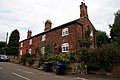
 / 52.97133; -1.67570 (Terrace of three cottages)
Cottages in Shirley - geograph.org.uk - 3611825.jpg
Early 19th centuryA pair of cottages and a barn, later three cottages, in red brick with a Welsh slate roof. There are two storeys and four bays. The doorway and windows, which are casements, have segmental-arched heads, and there are half-blocked vents in the former barn. [13] II
The Outlook
52°59′04″N1°40′20″W / 52.98455°N 1.67210°W / 52.98455; -1.67210 (The Outlook)
The Outlook, Shirley.jpg
Early 19th centuryThe cottage is in red brick, and has a tile roof with decorative fretted bargeboards, a single storey, and attics. On the east front is a gabled porch, and the windows have diamond glazing, some with hood moulds. [14] II
Saw Mill
52°58′57″N1°41′33″W / 52.98240°N 1.69247°W / 52.98240; -1.69247 (Saw Mill)
Osmaston Saw Mill 2022-02-07 09-17-04.jpg
c. 1845The former water-powered saw mill was designed by H. I. Stevens in picturesque style, and is built into a hillside. It is in limestone with sandstone dressings, and a stone slate roof with overhanging eaves supported on moulded wooden brackets. On the side is an open timber shelter with stone piers containing a large overshot waterwheel. The windows are recessed, chamfered and mullioned, and contain diamond lights, there are gabled roof dormers, and on the west gable is a ventilator. Attached to the east is a curved dam wall and an ornamental cascade. [15] II*
Seasoning shed
52°58′56″N1°41′33″W / 52.98230°N 1.69259°W / 52.98230; -1.69259 (Seasoning shed)
c. 1845The seasoning shed to the west of the saw mill was designed by H. I. Stevens. It is an open shed consisting of six iron posts supporting a pitched stone slate roof. [16] II
Cow House, Shirley Hall
52°58′24″N1°40′20″W / 52.97320°N 1.67230°W / 52.97320; -1.67230 (Cow House, Shirley Hall)
Mid 19th centuryThe cow house is in red brick with a tile roof. There is a single storey and a T-shaped plan. It contains windows with chamfered surrounds and Gothic-arched heads, doorways with segmental heads and chamfered surrounds, and patterned brick arches. [5] [17] II
Stable block, Shirley Hall
52°58′23″N1°40′23″W / 52.97312°N 1.67299°W / 52.97312; -1.67299 (Stable block, Shirley Hall)
Mid 19th centuryThe stable block is in red brick with a tile roof, and has a single storey with a hayloft, and an L-shaped plan. It contains windows with chamfered surrounds and Gothic-arched heads, doorways with segmental heads and chamfered surrounds, and patterned brick arches. Above is a gabled dormer with a segmental-arched granary opening. [5] [18] II
Stable block, The Old Rectory
52°58′18″N1°40′31″W / 52.97159°N 1.67516°W / 52.97159; -1.67516 (Stable block, The Old Rectory)
19th centuryThe former stable block is in red brick with a tile roof. There are two storeys and three bays. It contains four doorways with three windows above, and there are stone steps on the west leading to an upper doorway. Inside there are two cruck trusses. [19] II
Churchyard cross
52°58′18″N1°40′32″W / 52.97176°N 1.67561°W / 52.97176; -1.67561 (Churchyard cross)
UndatedThe cross in the churchyard of St Michael's Church is in sandstone. It consists of three square steps, on which is the tapering base of the cross and the lower part of the octagonal shaft. [20] II

Related Research Articles

Blackwell is a civil parish in the Bolsover District of Derbyshire, England. The parish contains eight listed buildings that are recorded in the National Heritage List for England. Of these, one is listed at Grade II*, the middle of the three grades, and the others are at Grade II, the lowest grade. The parish contains the villages of Blackwell and Newton, and the surrounding area. The listed buildings consist of houses cottages and associated structures, farmhouses, a church, and a tombstone in the churchyard.

Bradbourne is a civil parish in the Derbyshire Dales district of Derbyshire, England. The parish contains 16 listed buildings that are recorded in the National Heritage List for England. Of these, one is listed at Grade I, the highest of the three grades, one is at Grade II*, the middle grade, and the others are at Grade II, the lowest grade. The parish contains the village of Bradbourne and the surrounding countryside. The listed buildings consist of houses, cottages and associated structures, farmhouses and farm buildings, a church and items in the churchyard, and a former watermill and associated buildings.

Bradley is a civil parish in the Derbyshire Dales district of Derbyshire, England. The parish contains ten listed buildings that are recorded in the National Heritage List for England. Of these, one is listed at Grade II*, the middle of the three grades, and the others are at Grade II, the lowest grade. The parish contains the village of Bradley and the surrounding countryside. The listed buildings consist of houses and associated structures, farmhouses, a row of cottages with a central archway, and a church and a churchyard cross.

Brailsford is a civil parish in the Derbyshire Dales district of Derbyshire, England. The parish contains 35 listed buildings that are recorded in the National Heritage List for England. Of these, one is listed at Grade I, the highest of the three grades, and the others are at Grade II, the lowest grade. The parish contains the village of Brailsford and the hamlet of Ednaston, and the surrounding countryside. Most of the listed buildings are houses, cottages and associated structures, farmhouses and farm buildings. The other listed buildings include a church, a churchyard cross, a watermill, two boundary posts, two mileposts, a bridge, a school, and a well.

Calver is a civil parish in the Derbyshire Dales district of Derbyshire, England. The parish contains nine listed buildings that are recorded in the National Heritage List for England. Of these, one is listed at Grade II*, the middle of the three grades, and the others are at Grade II, the lowest grade. The parish contains the village of Calver and the surrounding area. The listed buildings consist of a house, a cottage, a farmhouse, a mounting block and a lamp standard, a bridge, a former schoolroom, a former mill and wheelhouse, and a milestone.

Castleton is a civil parish in the High Peak district of Derbyshire, England. The parish contains 25 listed buildings that are recorded in the National Heritage List for England. Of these, one is listed at Grade I, the highest of the three grades, one is at Grade II*, the middle grade, and the others are at Grade II, the lowest grade. The parish contains the village of Castleton and the surrounding countryside and moorland. The most important building in the parish is the ruined Peveril Castle, which is listed at Grade I. The other listed buildings include houses, cottages and associated structures, farmhouses and farm buildings, a church and a sundial in the churchyard, a hotel and a public house, a former watermill, three mileposts, a school, a war memorial, and a telephone kiosk.

Chelmorton is a civil parish in the Derbyshire Dales district of Derbyshire, England. The parish contains four listed buildings that are recorded in the National Heritage List for England. Of these, one is listed at Grade II*, the middle of the three grades, and the others are at Grade II, the lowest grade. The parish contains the village of Chelmorton and the surrounding area, and the listed buildings consist of a church, a cross in the churchyard, a farmhouse, and a barn.

Doveridge is a civil parish in the Derbyshire Dales district of Derbyshire, England. The parish contains 24 listed buildings that are recorded in the National Heritage List for England. Of these, one is listed at Grade I, the highest of the three grades, three are at Grade II*, the middle grade, and the others are at Grade II, the lowest grade. The parish contains the village of Doveridge and the surrounding countryside. Apart from a church, a cross in the churchyard, and a public house, all the listed buildings are houses, cottages and associated structures, farmhouses and farm buildings.

Eckington is a civil parish in the North East Derbyshire district of Derbyshire, England. The parish contains 81 listed buildings that are recorded in the National Heritage List for England. Of these, two are listed at Grade I, the highest of the three grades, two are at Grade II*, the middle grade, and the others are at Grade II, the lowest grade. The parish contains the town of Eckington, the villages of Renishaw, Ridgeway, and Spinkhill, the hamlet of Birley Hay, and the surrounding countryside. The major building in the parish is the country house, Renishaw Hall, which is listed, together with associated structures and items in its grounds. Most of the other listed buildings are houses, cottages and associated structures, farmhouses and farm buildings. The rest of the listed buildings include churches, chapels and associated items, a former Sunday school, a former toll house, a public house, and two bridges.

Edale is a civil parish in the High Peak district of Derbyshire, England. The parish contains 28 listed buildings that are recorded in the National Heritage List for England. All the listed buildings are designated at Grade II, the lowest of the three grades, which is applied to "buildings of national importance and special interest". The parish is almost entirely rural, consisting of countryside and moorland, and containing small settlements including Grindsbrook Booth and Barber Booth. Most of the listed buildings are houses, cottages, farmhouses and farm buildings. The other listed buildings include a church, a chapel, a public house, a sundial, two packhorse bridges, a former cotton mill, a war memorial, and a telephone kiosk.

Grindleford is a civil parish in the Derbyshire Dales district of Derbyshire, England. The parish contains 26 listed buildings that are recorded in the National Heritage List for England. Of these, one is listed at Grade I, the highest of the three grades, one is at Grade II*, the middle grade, and the others are at Grade II, the lowest grade. The parish contains the village of Grindleford and the surrounding countryside. Most of the listed buildings are houses, cottages and farmhouses and associated structures. The other listed buildings include a former gatehouse converted into a chapel, two bridges, a milestone and a milepost, a former cotton mill, a former toll house, and another chapel.

Hathersage is a civil parish in the Derbyshire Dales district of Derbyshire, England. The parish contains 54 listed buildings that are recorded in the National Heritage List for England. Of these, one is listed at Grade I, the highest of the three grades, three are at Grade II*, the middle grade, and the others are at Grade II, the lowest grade. The parish, which is almost entirely rural, contains the village of Hathersage and the surrounding countryside. Most of the listed buildings are farmhouses and farm buildings, houses, cottages, and associated structures. The other listed buildings include two churches, a cross shaft in a churchyard, a presbytery and a vicarage, two bridges, former mills, a milepost, a former toll house, a railway viaduct, and a lamp column.

Hope is a civil parish in the High Peak district of Derbyshire, England. The parish contains 23 listed buildings that are recorded in the National Heritage List for England. Of these, one is listed at Grade I, the highest of the three grades, and the others are at Grade II, the lowest grade. The parish contains the village of Hope and the surrounding countryside. Most of the listed buildings are houses, farmhouses and farm buildings. The other listed buildings include a church and items in the churchyard, a cross converted into a guide post, a hotel, a former toll house, two mileposts, the engine house and chimney of a former lead mine, a school, and a war memorial.

Kirk Ireton is a civil parish in the Derbyshire Dales district of Derbyshire, England. The parish contains 27 listed buildings that are recorded in the National Heritage List for England. Of these, one is listed at Grade I, the highest of the three grades, one is at Grade II*, the middle grade, and the others are at Grade II, the lowest grade. The parish contains the village of Kirk Ireton and the surrounding countryside. Most of the listed buildings are houses, cottages and associated structures, farmhouses and farm buildings, and the others are churches and associated structures, and a public house.

Longford is a civil parish in the Derbyshire Dales district of Derbyshire, England. The parish contains 22 listed buildings that are recorded in the National Heritage List for England. Of these, one is listed at Grade I, the highest of the three grades, four are at Grade II*, the middle grade, and the others are at Grade II, the lowest grade. The parish contains the village of Longford and the surrounding area. The major building in the parish is Longford Hall, which is listed, together with associated structures, and the adjacent farm and farm buildings. The other listed buildings include a church, a cross and tombs in the churchyard, houses and cottages, farmhouses, a row of almshouses, now in ruins, two bridges, a former watermill, and a former cheese factory.

Matlock Town is a civil parish in the Derbyshire Dales district of Derbyshire, England. The parish contains 44 listed buildings that are recorded in the National Heritage List for England. Of these, six are listed at Grade II*, the middle of the three grades, and the others are at Grade II, the lowest grade. The parish contains the town of Matlock and the surrounding area. Most of the listed buildings are houses, cottages and associated structures, farmhouses and farm buildings. During the middle of the 19th century, Matlock became a centre for hydrotherapy, and buildings known as hydros were built for this purpose. Two of the larger hydros have survived and are listed. The other listed buildings include churches, a chapel, items in a churchyard, public houses, bridges, a former malthouse, a bank, a milestone, a former smithy, and a war memorial.

Netherseal is a civil parish in the South Derbyshire district of Derbyshire, England. The parish contains eleven listed buildings that are recorded in the National Heritage List for England. Of these, three are listed at Grade II*, the middle of the three grades, and the others are at Grade II, the lowest grade. The parish contains the village of Netherseal and the surrounding countryside. The listed buildings consist of a church and churchyard walls, a chapel, houses and associated structures, a pigeoncote, a former smithy, a row of almshouses, a farmhouse and a former watermill.

Norbury and Roston is a civil parish in the Derbyshire Dales district of Derbyshire, England. The parish contains nine listed buildings that are recorded in the National Heritage List for England. Of these, two are listed at Grade I, the highest of the three grades, and the others are at Grade II, the lowest grade. The parish contains the village of Norbury, the hamlet of Roston, and the surrounding countryside. The listed buildings consist of a church and graves in the churchyard, a medieval hall house and an attached 17th-century country house, a former water mill and a drying kiln, a smaller house, and two bridges.

Risley is a civil parish in the Borough of Erewash in Derbyshire, England. The parish contains 17 listed buildings that are recorded in the National Heritage List for England. Of these, five are listed at Grade II*, the middle of the three grades, and the others are at Grade II, the lowest grade. The parish contains the village of Risley and the surrounding area. The listed buildings include a country house and structures in its grounds, a church and items in the churchyard, smaller houses, buildings associated with a school, a farmhouse and barn, and two mileposts.

Shirland and Higham is a civil parish in the North East Derbyshire district of Derbyshire, England. The parish contains 42 listed buildings that are recorded in the National Heritage List for England. Of these, one is listed at Grade II*, the middle of the three grades, and the others are at Grade II, the lowest grade. The parish contains the villages of Shirland, Higham and Stonebroom and the surrounding area. Most of the listed buildings are houses, cottages, farmhouses and farm buildings. The other listed buildings include two churches, a former Friends' meeting house and school, a former watermill, a village cross, bridges and mileposts.

References

Citations

Sources