
The Isle of Portland is a tied island, 6 kilometres (4 mi) long by 2.7 kilometres (1.7 mi) wide, in the English Channel. The southern tip, Portland Bill, lies 8 kilometres (5 mi) south of the resort of Weymouth, forming the southernmost point of the county of Dorset, England. A barrier beach called Chesil Beach joins Portland with mainland England. The A354 road passes down the Portland end of the beach and then over the Fleet Lagoon by bridge to the mainland. The population of Portland is 13,417.

The Jurassic Coast is a World Heritage Site on the English Channel coast of southern England. It stretches from Exmouth in East Devon to Studland Bay in Dorset, a distance of about 96 miles (154 km), and was inscribed on the World Heritage List in mid-December 2001.

Studland is a village and civil parish on the Isle of Purbeck in Dorset, England. The village is located about 2 miles (3.2 km) north of the town of Swanage, over a steep chalk ridge, and 3 miles (4.8 km) south of the South East Dorset conurbation at Sandbanks, from which it is separated by Poole Harbour. The parish includes Brownsea Island within the harbour. In the 2011 census the parish had 182 households and a population of 425, though many of the houses in the village are holiday homes, second homes, or guest houses, and the village's population varies depending upon the season.

Portland Harbour is located beside the Isle of Portland, Dorset, on the south coast of England. Construction of the harbour began in 1849; when completed in 1872, its 520-hectare (1,300-acre) surface area made it the largest human-made harbour in the world, and it remains one of the largest in the world today. It is naturally sheltered by Portland to the south, Chesil Beach to the west and mainland Dorset to the north. It consists of four breakwaters: two southern and two northern. These have a total length of 4.57 km (2.84 mi) and enclose approximately 1,000 ha of water.

West Bay, originally known as Bridport Harbour, is a small harbour settlement and resort on the English Channel coast in Dorset, England, sited at the mouth of the River Brit approximately 1.5 miles (2.4 km) south of Bridport. The area is part of the Jurassic Coast, a World Heritage Site.

Wakeham is a hamlet near the village of Easton, in Tophill on the Isle of Portland in Dorset, England. It is situated between the Straits part of Easton, and Pennsylvania Castle. As with the rest of Portland's villages and settlements, Wakeham has been designated as a conservation area, as it is a place of special architectural and historic interest. Easton, Wakeham and Reforne were designated pre-1974. The hamlet features a distinctively wide road running through it, once built to allow space for horse-drawn carts transporting stone by road. Many of Wakeham's older buildings of the 17th and 18th century survive.
Chesil Cove is a curved steep bank forming the south-east end of 29-kilometre (18 mi) Chesil Beach in Dorset, England. It is thus part of one of three large shingle structures in Britain, extending from West Bay to the Isle of Portland, the latter acting more firmly as a great barrier (groyne) which stops tidal action from washing the beach away and leads to the high depositions by wind and tide action forming the grand curved bank of this "cove". The "cove", bill and much of Chesil Beach give shelter from the prevailing winds and waves for much of Weymouth Bay, the town of Weymouth and the village of Chiswell. It forms part of the Jurassic Coast.

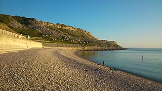
Church Ope Cove is a small secluded beach on the sheltered eastern side of the Isle of Portland in Dorset, southern England, and is part of the Jurassic Coast. It is found close to the village of Wakeham. The beach has many unusual features for the Isle of Portland. The beach used to be sandy, but quarry debris now covers the sand, and has been worn into rounded pebbles. The pebbles cover a small stream which runs to the sea, which is one of the few active streams remaining on the Isle of Portland.
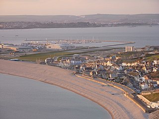
Chiswell, sometimes, is a small village at the southern end of Chesil Beach, in Underhill, on the Isle of Portland in Dorset. It is the oldest settlement on the island, having formerly been known as Chesilton. The small bay at Chiswell is called Chesil Cove, and the beach promenade and sea wall which form Chiswell's coastal defences are a prominent feature.

The Portland Branch railway refers to a group of lines on the Isle of Portland in the English county of Dorset. The first was the Portland Railway, a tramway with a counterbalanced rope-worked incline. It opened in 1826. It was followed by the Weymouth and Portland Railway, which connected to the main line of the Great Western Railway at Weymouth. It opened in 1865. From the late 1840s until 1872, Portland Breakwater was built, a prodigious construction task that created a very large safe harbour. It was decided to provide a railway connection to the breakwater, which was used as a pier for bunkering ships. This was constructed by the LSWR and the GWR jointly and opened in 1876. The fourth line was the Easton and Church Hope Railway. This line was conceived as a simple descent to bring stone down from quarries to a new jetty at Church Ope, but after their line was authorised in 1867, the Company delayed useful construction, and a change of plan followed, with several Acts of Parliament authorising modifications to the route and extension of time. It finally opened in 1900.
There are eight settlements on the Isle of Portland, Dorset, England, the largest of which are Fortuneswell in Underhill and Easton on Tophill. The other villages of Weston, Southwell, Wakeham and the Grove also occupy Tophill, and Castletown and Chiswell are the other villages in Underhill.
Balaclava Bay is a bay situated on the edge of Portland Harbour, where the breakwater meets the island, at the northern end of the Isle of Portland, Dorset, in southern England. The bay is overlooked by the Victorian East Weare Battery, built in the 1860s to protect the harbour. The nearest road within the dockyard of Portland Port is named Balaclava Road.

Hallelujah Bay is a bay located on the west side of the Isle of Portland, Dorset, England. The bay is situated below West Weares, with Clay Ope, Blacknor Point and Mutton Cove further south. Near the cove is a large mound of rock and earth beneath the clifftops known locally as the Green Hump.

Portland Raised Beach refers to small raised beaches on each side of Portland Bill, on the Isle of Portland, part of the Jurassic Coast in Dorset, England. The main one is known as the West Pleistocene Raised Beach; nearby is the East Pleistocene Raised Beach.

The Great Southwell Landslip occurred in 1734 on the Isle of Portland, Dorset, England near the southerly village of Southwell and extended for a length of 1.5 miles (2.4 km) between Durdle Pier and Freshwater Bay. It remains Britain's second largest recorded historical landslide.

The Salt Pans are two salt pans on the Isle of Portland, Dorset, England. Both pans sit next to one another, and are situated on the coastline of East Weares, the east side of Portland. The pans sit directly below the Young Offenders Institution HM Prison Portland, and are found close to various old historic relics such as the East Weare Rifle Range, Folly Pier, King's Pier and the remains of the Folly Pier Waterworks. The East Weares area, including the Salt Pans, has been labelled a Site of Special Scientific Interest (SSSI), largely due to the scrub and wildlife being of high nature conservation value.

Red Crane is a crane on the Isle of Portland, Dorset, England. It is located on the cliff edge at Portland's southerly point, the promontory Portland Bill. It is part of a disused stone loading quay, which is now a scheduled monument.

King's Pier is a 17th-century stone shipping quay, located on the Isle of Portland, Dorset, England; part of the Jurassic Coast. It is found at the boundary point of the land owned by Portland Port Ltd, on the east side of the island within the area of East Weares. To the north of the pier is Balaclava Bay, whilst further south along the coastline are the remains of Folly Pier and Folly Pier Waterworks, East Weare Rifle Range, the two Salt Pans, Little Beach and Durdle Pier respectively. When active, King's Pier was one of the most important stone shipping pier sites.

Folly Pier is a disused stone shipping quay, located on the Isle of Portland, Dorset, England; part of the Jurassic Coast. It is found on the east side of the island within the area of East Weares. Other piers within the area include King's Pier and Durdle Pier respectively. Folly Pier dates from the 17th century.

