
The York River is a river in Renfrew County, Hastings County and Haliburton County in Ontario, Canada. The river is in the Saint Lawrence River drainage basin, and flows from the southern extension of Algonquin Provincial Park to the Madawaska River.
The Little Madawaska River is a river in the Saint Lawrence River drainage basin in the Unorganized South Part of Nipissing District in northeastern Ontario, Canada. The river is entirely within Algonquin Provincial Park, and is a right tributary of the Petawawa River and not a tributary of the nearby Madawaska River.
Black Donald Lake is a reservoir lake in the Township of Greater Madawaska, Renfrew County, and the Township of North Frontenac, Frontenac County, in Eastern Ontario, Canada. It is on the Madawaska River and is part of the Saint Lawrence River drainage basin.
Bobs Lake is a lake in Brudenell, Lyndoch and Raglan, Renfrew County in Eastern Ontario, Canada. It is in the Saint Lawrence River drainage basin and is part of the Madawaska River system. The nearest settlement is Hardwood Lake, 4 kilometres (2 mi) to the east.

Centennial Lake is a reservoir lake in the Township of Greater Madawaska, Renfrew County, and the Township of North Frontenac, Frontenac County, in Eastern Ontario, Canada. It is on the Madawaska River and is part of the Saint Lawrence River drainage basin.
Calabogie Lake is a reservoir lake in the municipality of Greater Madawaska, Renfrew County, in Eastern Ontario, Canada. It is part of the Saint Lawrence River drainage basin, and is located on the Madawaska River system, in the geographic townships of Bagot and Blythfield.
Stoughtons Creek is a stream in Greater Madawaska, Renfrew County in Eastern Ontario, Canada. The creek is in the Saint Lawrence River drainage basin.

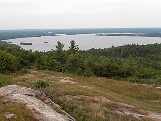
The Centennial Lake Provincial Nature Reserve is a provincial park located in the municipality of Greater Madawaska, Renfrew County, in Eastern Ontario, Canada. The 530-hectare (1,300-acre) reserve was created in 1989 and is managed by Ontario Parks.
Black Donald Creek is a stream in Greater Madawaska, Renfrew County in Eastern Ontario, Canada. It is in the Saint Lawrence River drainage basin and is a left tributary of the Madawaska River at Black Donald Lake.
Doorley Creek is a stream in Greater Madawaska, Renfrew County in Eastern Ontario, Canada. It is in the Saint Lawrence River drainage basin and is a right tributary of Black Donald Creek.
Malotte Creek is a stream in Greater Madawaska, Renfrew County in Eastern Ontario, Canada. It is in the Saint Lawrence River drainage basin and is a left tributary of Black Donald Creek.
Tooeys Creek is a stream in Greater Madawaska, Renfrew County in Eastern Ontario, Canada. It is in the Saint Lawrence River drainage basin and, together with an unnamed stream, combines to form Black Donald Creek.
Malotte Lake is a lake in Greater Madawaska, Renfrew County in Eastern Ontario, Canada. It is in the Saint Lawrence River drainage basin and is the source of Malotte Creek.
Tooeys Lake is a lake in Greater Madawaska, Renfrew County in Eastern Ontario, Canada. It is in the Saint Lawrence River drainage basin and is the source of Tooeys Creek.
Mud Lake is a lake in Greater Madawaska, Renfrew County in Eastern Ontario, Canada. It is in geographic Brougham Township, is part of the Saint Lawrence River drainage basin, and is the source of Little Black Donald Creek.
Mud Lake is a lake in Greater Madawaska, Renfrew County in Eastern Ontario, Canada. It is in geographic Blithfield Township, and is part of the Saint Lawrence River drainage basin.
McKenzie Lake is a lake in South Algonquin, Nipissing District and Hastings Highlands, Hastings County in Ontario, Canada. It is in the Saint Lawrence River drainage basin, is part of the Madawaska River river system, and lies about 14 kilometres (9 mi) south of the community of Madawaska and a similar distance north of the small town of Maynooth. The settlement of McKenzie Lake is on the north shore of the lake.
Little Straggle Lake is a lake in the municipality of Dysart et al, Haliburton County in Central Ontario, Canada. It lies at an elevation of 411 metres (1,348 ft), has an area of 38.3 hectares, and is in the Ottawa River drainage basin.
Straggle Creek is a stream in the municipality of Dysart et al, Haliburton County in Central Ontario, Canada. It is a right tributary of Allen Creek and is in the Ottawa River drainage basin.
Allen Creek is a stream in the municipality of Dysart et al, Haliburton County in Central Ontario, Canada. It is a tributary of Benoir Lake and is in the Ottawa River drainage basin.
