Little Eagle, South Dakota

Last updated • 2 min readFrom Wikipedia, The Free Encyclopedia

Little Eagle, South Dakota
CDP
Corson County South Dakota Incorporated and Unincorporated areas Little Eagle Highlighted.svg
Location in Corson County and the state of South Dakota
Coordinates: 45°41′00″N100°47′48″W / 45.68333°N 100.79667°W / 45.68333; -100.79667
Country United States
State South Dakota
County Corson
Area
[1]
  Total1.42 sq mi (3.69 km2)
  Land1.40 sq mi (3.62 km2)
  Water0.03 sq mi (0.07 km2)
Elevation
[2]
1,647 ft (502 m)
Population
 (2020) [3]
  Total367
  Density262.52/sq mi (101.37/km2)
Time zone UTC-7 (Mountain (MST))
  Summer (DST) UTC-6 (MDT)
ZIP code
57639
Area code 605
FIPS code 46-37900 [4]
GNIS feature ID2393103 [2]

Little Eagle (Lakota: Waŋblí Čik’ala [5] ) is a census-designated place (CDP) in Corson County, South Dakota, United States. The population was 319 at the 2010 census.

Contents

The community has the name of a Native American chieftain. [6]

Geography

According to the United States Census Bureau, the CDP has a total area of 1.4 square miles (3.6 km2), of which 1.4 square miles (3.6 km2) is land and 0.04 square miles (0.10 km2) (2.10%) is water.

Demographics

Historical population
CensusPop.Note
2020 367
U.S. Decennial Census [7]

As of the census [4] of 2000, there were 370 people, 71 households, and 60 families residing in the CDP. The population density was 262.9 inhabitants per square mile (101.5/km2). There were 74 housing units at an average density of 52.6 per square mile (20.3/km2). The racial makeup of the CDP was 0.54% White, 99.19% Native American, and 0.27% from two or more races. Hispanic or Latino of any race were 2.70% of the population.

There were 71 households, out of which 53.5% had children under the age of 18 living with them, 28.2% were married couples living together, 40.8% had a female householder with no husband present, and 14.1% were non-families. 9.9% of all households were made up of individuals, and 1.4% had someone living alone who was 65 years of age or older. The average household size was 5.21 and the average family size was 5.43.

In the CDP, the population was spread out, with 48.4% under the age of 18, 13.8% from 18 to 24, 24.1% from 25 to 44, 10.8% from 45 to 64, and 3.0% who were 65 years of age or older. The median age was 19 years. For every 100 females, there were 87.8 males. For every 100 females age 18 and over, there were 96.9 males.

The median income for a household in the CDP was $12,500, and the median income for a family was $11,528. Males had a median income of $20,625 versus $12,321 for females. The per capita income for the CDP was $3,632. About 75.4% of families and 73.4% of the population were below the poverty line, including 76.8% of those under age 18 and 50.0% of those age 65 or over.

Local media

FM Radio

FM radio stations
FrequencyCall signNameFormatOwnerTarget city/market City of license
89.5 FM KLND, "The Lodge of Good Voices" Variety Seventh Generation Media Services, IncLittle EagleLittle Eagle

Notable person

Related Research Articles

<span class="mw-page-title-main">Lakota, North Dakota</span> City in North Dakota, United States

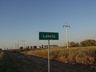
Lakota is a city in Nelson County, North Dakota, United States. It is the county seat of Nelson County Lakota is located 63 miles west of Grand Forks and 27 miles east of Devils Lake. The population was 683 at the 2020 census, making Lakota the 75th-largest city in North Dakota.

<span class="mw-page-title-main">Green Grass, South Dakota</span> CDP in South Dakota, United States

Green Grass is a census-designated place (CDP) in Dewey County, South Dakota, United States. The population was 21 at the 2020 census.

<span class="mw-page-title-main">La Plant, South Dakota</span> Census-designated place in South Dakota, United States

La Plant is a census-designated place (CDP) in Dewey County, South Dakota, United States. The population was 167 at the 2020 census. It is within the Cheyenne River Indian Reservation.

<span class="mw-page-title-main">North Eagle Butte, South Dakota</span> Census-designated place in South Dakota, United States

North Eagle Butte is a census-designated place (CDP) in Dewey County, South Dakota, United States, along the 45th parallel. The population was 1,879 at the 2020 census.

<span class="mw-page-title-main">Wanblee, South Dakota</span> Census-designated place in South Dakota, United States

Wanblee is a census-designated place on the Pine Ridge Indian Reservation, located in Jackson County, South Dakota, United States. The population was 674 at the 2020 census, virtually all of whom are members of the Oglala tribe of Lakota Sioux. Wanbli is the Lakota word for eagle, and the town was named for its proximity to Wanbli hohpi paha. Wanblee is a few miles directly northeast of the North American continental pole of inaccessibility.

<span class="mw-page-title-main">Lower Brule, South Dakota</span> Census-designated place in South Dakota, United States

Lower Brule is a census-designated place (CDP) in Lyman County, South Dakota, United States. The population was 703 at the 2020 census. The community is located within the Lower Brule Indian Reservation, from which it takes its name.

<span class="mw-page-title-main">White River, South Dakota</span> City in South Dakota, United States

White River is a city in and the county seat of Mellette County. South Dakota, United States. The population was 533 at the 2020 census.

<span class="mw-page-title-main">Green Valley, South Dakota</span> CDP in South Dakota, United States

Green Valley is a census-designated place (CDP) and unincorporated community in Pennington County, South Dakota, United States. The population was 1,051 at the 2020 census.

<span class="mw-page-title-main">Batesland, South Dakota</span> Town in South Dakota, United States

Batesland is a town in Oglala Lakota County, South Dakota, United States. The population was 100 at the 2020 census.

<span class="mw-page-title-main">Kyle, South Dakota</span> CDP in South Dakota, United States

Kyle is a census-designated place (CDP) in Oglala Lakota County, South Dakota, United States. Its population was 943 at the 2020 census. Located within the Pine Ridge Indian Reservation of the Oglala Lakota, it is one of two settlements which are closest to the North American continental pole of inaccessibility.

<span class="mw-page-title-main">Manderson-White Horse Creek, South Dakota</span> CDP in South Dakota, United States

Manderson-White Horse Creek is a census-designated place (CDP) in East Oglala Lakota Unorganized Territory in Oglala Lakota County, South Dakota, United States. The population was 554 at the 2020 census. Oglala Lakota tribesman, Kicking Bear died here on May 28, 1904. He fought in several battles during the Black Hills War, including Battle of the Greasy Grass. His nephew, Felix Flying Hawk owned a ranch.

<span class="mw-page-title-main">Oglala, South Dakota</span> CDP in South Dakota, United States

Oglala is a census-designated place (CDP) in West Oglala Lakota Unorganized Territory equivalent, Oglala Lakota County, South Dakota, United States. The population was 1,282 at the 2020 census. Its location is in the northwest of the Pine Ridge Indian Reservation.

<span class="mw-page-title-main">Pine Ridge, South Dakota</span> CDP in South Dakota, United States

Pine Ridge is a census-designated place (CDP) and the most populous community in Oglala Lakota County, South Dakota, United States. The population was 3,138 at the 2020 census. It is the tribal headquarters of the Oglala Sioux Tribe on the Pine Ridge Indian Reservation.

<span class="mw-page-title-main">Porcupine, South Dakota</span> CDP in South Dakota, United States

Porcupine is a census-designated place (CDP) in Oglala Lakota County, South Dakota, United States. The population was 925 at the 2020 census.

<span class="mw-page-title-main">Wounded Knee, South Dakota</span> CDP in South Dakota, United States

Wounded Knee is a census-designated place (CDP) on the Pine Ridge Indian Reservation in Oglala Lakota County, South Dakota, United States. The population was 364 at the 2020 census.

<span class="mw-page-title-main">Parmelee, South Dakota</span> CDP in South Dakota, United States

Parmelee also Wósoso is a census-designated place (CDP) in Todd County, South Dakota, United States, which lies within the Rosebud Indian Reservation. The population was 606 at the 2020 census.

<span class="mw-page-title-main">Rosebud, South Dakota</span> CDP in South Dakota, United States

Rosebud also Sicanġu is a census-designated place (CDP) in Todd County, South Dakota, United States. The population was 1,455 at the 2020 census.

<span class="mw-page-title-main">Two Strike, South Dakota</span> CDP in South Dakota, United States

Two Strike is a census-designated place (CDP) in Todd County, South Dakota, United States, named after Brulé, Lakota chief Two Strike who lived at that location for a period of time. The population was 282 at the 2020 census.

<span class="mw-page-title-main">White Horse, South Dakota</span> CDP in South Dakota, United States

White Horse also Šuŋgská oyáŋke is a census-designated place (CDP) in Todd County, South Dakota, United States. The population was 234 at the 2020 census.

<span class="mw-page-title-main">Eagle Butte, South Dakota</span> City in South Dakota, United States

Eagle Butte is a city in Dewey and Ziebach counties in South Dakota, United States. The population was 1,258 at the 2020 census. It is adjacent to the North Eagle Butte CDP.

References

  1. "ArcGIS REST Services Directory". United States Census Bureau. Retrieved October 15, 2022.
  2. 1 2 U.S. Geological Survey Geographic Names Information System: Little Eagle, South Dakota
  3. "Census Population API". United States Census Bureau. Retrieved October 15, 2022.
  4. 1 2 "U.S. Census website". United States Census Bureau . Retrieved January 31, 2008.
  5. Ullrich, Jan F. (2014). New Lakota Dictionary (2nd ed.). Bloomington, IN: Lakota Language Consortium. ISBN   978-0-9761082-9-0. Archived from the original on October 18, 2016. Retrieved February 13, 2014.
  6. Federal Writers' Project (1940). South Dakota place-names, v.1-3. University of South Dakota. p. 48.
  7. "Census of Population and Housing". Census.gov. Retrieved June 4, 2016.