Little River (Canadian River)

Last updated
The Little River near Sasakwa, Oklahoma Little River OK.jpg
The Little River near Sasakwa, Oklahoma
The Little River near Tecumseh, Oklahoma Little River Okla.jpg
The Little River near Tecumseh, Oklahoma

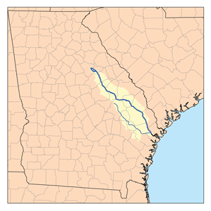
The Little River is a tributary of the Canadian River, 90 miles (140 km) long, in central Oklahoma in the United States. Via the Canadian and Arkansas rivers, it is part of the watershed of the Mississippi River.

Tributary stream or river that flows into a main stem river or lake

A tributary or affluent is a stream or river that flows into a larger stream or main stem river or a lake. A tributary does not flow directly into a sea or ocean. Tributaries and the main stem river drain the surrounding drainage basin of its surface water and groundwater, leading the water out into an ocean.

Canadian River river in Texas and Oklahoma

The Canadian River is the longest tributary of the Arkansas River in the United States. It is about 906 miles (1,458 km) long, starting in Colorado and traveling through New Mexico, the Texas Panhandle, and Oklahoma. The drainage area is about 47,700 square miles (124,000 km2).

Oklahoma State of the United States of America

Oklahoma is a state in the South Central region of the United States, bordered by Kansas on the north, Missouri on the northeast, Arkansas on the east, Texas on the south, New Mexico on the west, and Colorado on the northwest. It is the 20th-most extensive and the 28th-most populous of the fifty United States. The state's name is derived from the Choctaw words okla and humma, meaning "red people". It is also known informally by its nickname, "The Sooner State", in reference to the non-Native settlers who staked their claims on land before the official opening date of lands in the western Oklahoma Territory or before the Indian Appropriations Act of 1889, which dramatically increased European-American settlement in the eastern Indian Territory. Oklahoma Territory and Indian Territory were merged into the State of Oklahoma when it became the 46th state to enter the union on November 16, 1907. Its residents are known as Oklahomans, and its capital and largest city is Oklahoma City.

Contents

It rises in Moore in northwestern Cleveland County and flows generally southeastwardly through Pottawatomie, Seminole and Hughes counties. It joins the Canadian River about 5 miles (8 km) south of Holdenville. In Cleveland County the river is dammed to form Lake Thunderbird. Downstream of the lake, several sections of the river have been straightened and channelized.

Moore, Oklahoma City in Oklahoma, United States

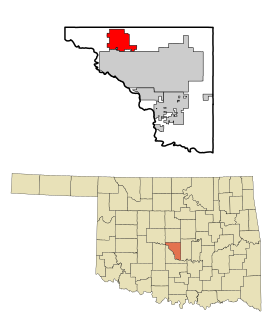
Moore is a city in Cleveland County, Oklahoma, United States, and is part of the Oklahoma City metropolitan area. The population was 55,081 at the 2010 census, making Moore the 7th largest city in the state of Oklahoma.

Cleveland County, Oklahoma County in the United States

Cleveland County is a county in the central part of the U.S. state of Oklahoma. The population was 255,755 at the 2010 census, making it the third-most populous county in Oklahoma. Its county seat is Norman. The county was named after U.S. President Grover Cleveland.

Pottawatomie County, Oklahoma County in the United States

Pottawatomie County is a county located in the U.S. state of Oklahoma. As of the 2010 census, the population was 69,442. Its county seat is Shawnee.

See also

Related Research Articles

Cleveland, Florida Census-designated place in Florida, United States

Cleveland is a census-designated place (CDP) in Charlotte County, Florida, United States. The population was 2,990 at the 2010 census. It is part of the Punta Gorda Metropolitan Statistical Area.

Broad River (Carolinas) river in North and South Carolina, United States

The Broad River is a principal tributary of the Congaree River, about 150 miles (240 km) long, in western North Carolina and northern South Carolina in the United States. Via the Congaree, it is part of the watershed of the Santee River, which flows to the Atlantic Ocean.

Yalobusha River river in the United States of America

The Yalobusha River is a river, 165 miles (266 km) long, in north-central Mississippi in the United States. It is a principal tributary of the Yazoo River, via which it is part of the watershed of the Mississippi River.

Maple River (North Dakota) river in North Dakota, United States of America

The Maple River is a tributary of the Sheyenne River, about 198 miles (319 km) long, in the Red River Valley of eastern North Dakota in the United States. Via the Sheyenne River, the Red River of the North, Lake Winnipeg and the Nelson River, the Maple is part of the watershed of Hudson Bay.

Elk River (Minnesota) river in east-central Minnesota in the United States

The Elk River is an 84.0-mile-long (135.2 km) river in east-central Minnesota in the United States. It is a tributary of the Mississippi River, draining a watershed of 630 square miles (1,600 km2).

Whetstone River river in the United States of America

The Whetstone River is a 12.7-mile-long (20.4 km) tributary of the Minnesota River in northeastern South Dakota and a very small portion of western Minnesota in the United States. Via the Minnesota River, it is part of the watershed of the Mississippi River.

Mustinka River river in Minnesota

The Mustinka River is a tributary of Lake Traverse, 68 mi (109 km) long, in western Minnesota in the United States. Via Lake Traverse, the Bois de Sioux River, the Red River of the North, Lake Winnipeg, and the Nelson River, it is part of the watershed of Hudson Bay. The river drains an area of 909 square miles (2,350 km2).

Salt Fork Arkansas River river in the United States of America

The Salt Fork of the Arkansas River is a 239-mile-long (385 km) tributary of the Arkansas River in southern Kansas and northern Oklahoma in the United States. Via the Arkansas River, it is part of the watershed of the Mississippi River.

Chikaskia River river in the United States of America

The Chikaskia River is a 159-mile-long (256 km) tributary of the Salt Fork of the Arkansas River in southern Kansas and northern Oklahoma in the United States. Via the Salt Fork and Arkansas rivers, it is part of the watershed of the Mississippi River.

Manitowoc River river in the United States of America

The Manitowoc River is a 35.8-mile-long (57.6 km) river in eastern Wisconsin in the United States. It flows into Lake Michigan at the city of Manitowoc.

Buffalo River (Wisconsin) river in Wisconsin, USA, tributary of the Mississippi

The Buffalo River is a 68.7-mile-long (110.6 km) left-tributary of the Mississippi River in western Wisconsin in the United States.

Canoochee River river in the United States of America

The Canoochee River is a 108-mile-long (174 km) river in southeastern Georgia in the United States. It is a tributary of the Ogeechee River, which flows to the Atlantic Ocean. In 1738 the Trustees of the colony mentioned the proposed house and ferry boat over the 'Cooanoochi River'.

Chippewa River (Minnesota) river in the United States of America

The Chippewa River is a 153-mile-long (246 km) tributary of the Minnesota River in western and southwestern Minnesota in the United States. Via the Minnesota River, it is part of the watershed of the Mississippi River.

Mountain Fork river in the United States of America

Mountain Fork, also known as the Mountain Fork of the Little River, is a 98-mile-long (158 km) tributary of the Little River in western Arkansas and southeastern Oklahoma in the United States. Via the Little and Red rivers, it is part of the watershed of the Mississippi River.

Glover River river in the United States of America

The Glover River is a 33.2-mile-long (53.4 km) tributary of the Little River in the Ouachita Mountains of southeastern Oklahoma in the United States. Via the Little and Red rivers, it is part of the watershed of the Mississippi River.

Little River (St. Francis River tributary) tributary of the St. Francis River, Missouri and Arkansas, United States of America

The Little River is a tributary of the St. Francis River, about 148 miles (238 km) long, in southeastern Missouri and northeastern Arkansas in the United States. Via the St. Francis, it is part of the watershed of the Mississippi River.

The Pacolet River is a tributary of the Broad River, about 50 miles (80 km) long, in northwestern South Carolina in the United States. One of its principal headwaters tributaries also drains a small portion of western North Carolina. Via the Broad and Congaree Rivers, it is part of the watershed of the Santee River, which flows to the Atlantic Ocean. The stream's name has also been spelled historically as "Pacolate River". There is a Pacolet River in Polk County in Florida.

The Second Broad River is a tributary of the Broad River in western North Carolina in the United States. Via the Broad and Congaree rivers, it is part of the watershed of the Santee River, which flows to the Atlantic Ocean.

Little River (Red River tributary) river in Oklahoma and Arkansas, United States of America

The Little River is a tributary of the Red River, with a total length of 217 miles (349 km), 130 miles (210 km) in southeastern Oklahoma and 87 miles (140 km) in southwestern Arkansas. in southeastern Oklahoma and southwestern Arkansas in the United States. Via the Red, it is part of the watershed of the Mississippi River. Six large reservoirs impound the Little River and its tributaries. The drainage basin of the river totals 4,204 square miles (10,890 km2), 2,204 square miles (5,710 km2) in Oklahoma and 2,036 square miles (5,270 km2) in Arkansas. The Little River and its upper tributaries are popular for recreational canoeing and kayaking.

References

DeLorme company

DeLorme is a producer of personal satellite tracking, messaging, and navigation technology. The company’s main product, inReach, integrates GPS and satellite technologies. inReach provides the ability to send and receive text messages anywhere in the world by using the Iridium satellite constellation. By pairing with a smart phone, navigation is possible with access to free downloadable topographic maps and NOAA charts. On February 11, 2016, the company announced that it had been purchased by Garmin, a multinational producer of GPS products and services.

International Standard Book Number Unique numeric book identifier

The International Standard Book Number (ISBN) is a numeric commercial book identifier which is intended to be unique. Publishers purchase ISBNs from an affiliate of the International ISBN Agency.

United States Geological Survey Scientific agency of the United States government

The United States Geological Survey is a scientific agency of the United States government. The scientists of the USGS study the landscape of the United States, its natural resources, and the natural hazards that threaten it. The organization has four major science disciplines, concerning biology, geography, geology, and hydrology. The USGS is a fact-finding research organization with no regulatory responsibility.

Coordinates: 34°59′49″N96°21′54″W / 34.99694°N 96.36500°W / 34.99694; -96.36500 (Little River)

Geographic coordinate system Coordinate system

A geographic coordinate system is a coordinate system that enables every location on Earth to be specified by a set of numbers, letters or symbols. The coordinates are often chosen such that one of the numbers represents a vertical position and two or three of the numbers represent a horizontal position; alternatively, a geographic position may be expressed in a combined three-dimensional Cartesian vector. A common choice of coordinates is latitude, longitude and elevation. To specify a location on a plane requires a map projection.