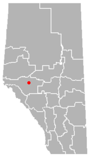
Lobstick is an unincorporated community in central Alberta, Canada within Yellowhead County.

Central Alberta is a region located in the Canadian province of Alberta.

Canada is a country in the northern part of North America. Its ten provinces and three territories extend from the Atlantic to the Pacific and northward into the Arctic Ocean, covering 9.98 million square kilometres, making it the world's second-largest country by total area. Canada's southern border with the United States is the world's longest bi-national land border. Its capital is Ottawa, and its three largest metropolitan areas are Toronto, Montreal, and Vancouver. As a whole, Canada is sparsely populated, the majority of its land area being dominated by forest and tundra. Consequently, its population is highly urbanized, with over 80 percent of its inhabitants concentrated in large and medium-sized cities, many near the southern border. Canada's climate varies widely across its vast area, ranging from arctic weather in the north, to hot summers in the southern regions, with four distinct seasons.

Yellowhead County is a municipal district in west central Alberta, Canada.
It is located on the Yellowhead Highway (Highway 16), approximately 116 kilometers (72 mi) west of Edmonton. It is established on the banks of the Lobstick River, downstream from Chip Lake. It has an elevation of 780 meters (2,560 ft).

The Yellowhead Highway is a major interprovincial highway in Western Canada that runs from Winnipeg to Graham Island off the coast of British Columbia via Saskatoon and Edmonton. It stretches across the four western Canadian provinces of British Columbia, Alberta, Saskatchewan, and Manitoba and is part of the Trans-Canada Highway system and the larger National Highway System, but should not be confused with the more southerly, originally-designated Trans-Canada Highway. The highway was officially opened in 1970. Beginning in 1990, the green and white Trans-Canada logo was used to designate the roadway.

Alberta Provincial Highway No. 16, commonly referred to as Highway 16, is a major east–west highway in central Alberta, Canada, connecting Jasper to Lloydminster via Edmonton. It forms a portion of the Yellowhead Highway, a major interprovincial route of the Trans-Canada Highway system that stretches from Masset, British Columbia to Portage la Prairie, Manitoba, near Winnipeg. Highway 16 spans approximately 634 km (394 mi) from Alberta's border with British Columbia in the west to its border with Saskatchewan in the east. As of 2010, all but less than 96 km (60 mi) of the route was divided, with a minimum of two lanes in each direction. It is designated a core route in Canada's National Highway System.
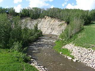
The Lobstick River is a small river in originating in west-central Alberta, Canada. It flows north from the foothills before entering Chip Lake. It then flows eastward through the community of Lobstick before joining the Pembina River, which in turn flows into the Athabasca River.