
The Saskatchewan River is a major river in Canada, about 550 kilometres (340 mi) long, flowing roughly eastward across Saskatchewan and Manitoba to empty into Lake Winnipeg. Through its tributaries the North Saskatchewan and South Saskatchewan, its watershed encompasses much of the prairie regions of central Canada, stretching westward to the Rocky Mountains in Alberta and northwestern Montana in the United States. It reaches 1,939 kilometres (1,205 mi) to its farthest headwaters on the Bow River, a tributary of the South Saskatchewan in Alberta.

The Athabasca River is a river in Alberta, Canada, which originates at the Columbia Icefield in Jasper National Park and flows more than 1,231 km (765 mi) before emptying into Lake Athabasca. Much of the land along its banks is protected in national and provincial parks, and the river is designated a Canadian Heritage River for its historical and cultural importance. The scenic Athabasca Falls is located about 30 km (19 mi) upstream from Jasper.

The Humber River is a river in Southern Ontario, Canada. It is in the Great Lakes Basin, is a tributary of Lake Ontario and is one of two major rivers on either side of the city of Toronto, the other being the Don River to the east. It was designated a Canadian Heritage River on September 24, 1999.

The Peace River is a 1,923-kilometre-long (1,195 mi) river in Canada that originates in the Rocky Mountains of northern British Columbia and flows to the northeast through northern Alberta. The Peace River joins the Athabasca River in the Peace-Athabasca Delta to form the Slave River, a tributary of the Mackenzie River. The Finlay River, the main headwater of the Peace River, is regarded as the ultimate source of the Mackenzie River. The combined Finlay–Peace–Slave–Mackenzie river system is the 13th longest river system in the world.

Judge C. R. Magney State Park is a state park in the U.S. state of Minnesota, on the North Shore of Lake Superior. It was named for Clarence R. Magney, a former mayor of Duluth and justice of the Minnesota Supreme Court, who was instrumental in getting 11 state parks and scenic waysides established along the North Shore. The park is best known for the Devil's Kettle, an unusual waterfall and rock formation in which half of the Brule River disappears into a pothole.

The North Saskatchewan River is a glacier-fed river that flows from the Canadian Rockies continental divide east to central Saskatchewan, where it joins with the South Saskatchewan River to make up the Saskatchewan River. Its water flows eventually into the Hudson Bay.

The Hay River is a large river in northern Alberta and southern Northwest Territories, Canada.

The Pembina River is a tributary of the Athabasca River in central Alberta, Canada.

The Northern Woods and Water Route is a 2,400-kilometre (1,500 mi) route through northern British Columbia, Alberta, Saskatchewan and Manitoba in Western Canada. As early as the 1950s, community groups came together to establish a northern travel route; this was proposed as the Northern Yellowhead Transportation Route. The Northern Woods and Water Route Association was established in 1974, and encouraged promotion of the route with the promise of an increase in tourist travel. The route was designated in 1974 and is well signed throughout its component highways. The route starts at Dawson Creek as the Spirit River Highway and ends at the Perimeter of Winnipeg, Manitoba, after running through the northern regions of the western provinces. From west to east, the Northern Woods and Water Route (NWWR) incorporates portions of British Columbia Highway 49; Alberta Highways 49, 2A, 2, & 55; Saskatchewan Highways 55 & 9; Manitoba Provincial Road 283 and Trunk Highways 10, 5, 68 & 6. The halfway point of the NWWR is approximately at Goodsoil, Saskatchewan.

Beaver River is a large river in east-central Alberta and central Saskatchewan, Canada. It flows east through Alberta and Saskatchewan and then turns sharply north to flow into Lac Île-à-la-Crosse on the Churchill River which flows into Hudson Bay.

The Brazeau River is a river in western Alberta, Canada. It is a major tributary of the North Saskatchewan River.

Wildwood is a hamlet in west-central Alberta, Canada within Yellowhead County. It is located on the Yellowhead Highway, approximately 112 kilometres (70 mi) west of Edmonton and 82 kilometres (51 mi) east of Edson. The Yellowhead Highway's intersection with Cowboy Trail is 9 kilometres (5.6 mi) east of the hamlet. The Lobstick River, which flows from Chip Lake to the west, runs through the hamlet.
Cardinal River is a short river in western Alberta, Canada. It flows from the Canadian Rockies, and empties into the Brazeau River, itself a major tributary of the North Saskatchewan River.

Chip Lake is a large lake in west-central Alberta. The Lobstick River flows through the lake. It in turn is a tributary of the Pembina River, which eventually flows into the Athabasca River.
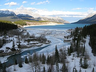
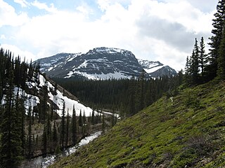
The Cline River is a short river in western Alberta, Canada. It flows from Pinto Lake and joins the North Saskatchewan River at Lake Abraham in west-central Alberta.
The Paddle River is a short river in northern Alberta, Canada. Known as Pimiskāw sīpiy by the Cree, the river was named because of its slow speed. During the fur trade era, a canoe could be easily paddled up the river, in contrast to the more arduous task of ascending a swifter river like the Pembina River that required poling or tracking.

The Medicine River is a medium-sized river in central Alberta. It begins at the outlet of Medicine Lake, north of Rocky Mountain House. The Medicine River initially travels through the Rocky Mountain House Grazing Reserve, a protected area with over 15,000 acres (61 km2) of land set aside for cattle grazing and recreation. The river flows southwest, taking on a number of creeks before passing Eckville. The Medicine River joins the Red Deer River north of Innisfail, downstream of the Dickson Dam, at the Medicine Flats. The Medicine is bridged by Alberta highways 53, 12, 11, and 54.

This article covers the water based Canadian canoe routes used by early explorers of Canada with special emphasis on the fur trade.
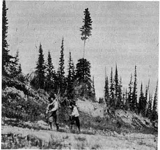
Lobsticks are traditional markers found in the Boreal Forests of Canada created by removing the middle branches of a coniferous (pine) tree.
Magnolia is a farming and ranching community located within Parkland County in the Canadian province of Alberta. It is on the west end of Isle Lake and east of the Pembina River in west-central Alberta.

