Lochiel, Mpumalanga

Last updated
Lochiel

Lohiya
South Africa Mpumalanga location map.svg
Red pog.svg
Lochiel
South Africa adm location map.svg
Red pog.svg
Lochiel
Coordinates: 26°08′10″S30°47′10″E / 26.136°S 30.786°E / -26.136; 30.786 Coordinates: 26°08′10″S30°47′10″E / 26.136°S 30.786°E / -26.136; 30.786
Country South Africa
Province Mpumalanga
District Gert Sibande
Municipality Albert Luthuli
Area
[1]
  Total8.01 km2 (3.09 sq mi)
Population
(2001) [1]
  Total2,805
  Density350/km2 (910/sq mi)
Racial makeup (2001)
[1]
   Black African 99.6%
   Coloured 0.4%
First languages (2001)
[1]
   Swazi 83.5%
   Zulu 14.6%
   Afrikaans 0.8%
   Sotho 0.5%
  Other0.6%
Time zone UTC+2 (SAST)
Postal code (street)
2337
PO box
2337

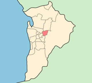
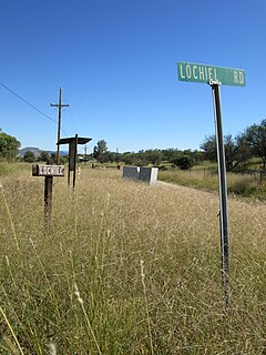
Lochiel is a small forestry town in Gert Sibande District Municipality in the Mpumalanga province of South Africa. It lies near the border with Swaziland.

Gert Sibande District Municipality District municipality in Mpumalanga, South Africa

Gert Sibande is one of the 3 districts of Mpumalanga province of South Africa. The seat of Gert Sibande is Ermelo. The majority of its 900 007 people speak IsiZulu. The district code is DC30. On 15 October 2004, the municipality changed its name from the "Eastvaal" to "Gert Sibande" District Municipality. The district is named after the ANC activist Gert Sibande.

Mpumalanga Province of South Africa

Mpumalanga is a province of South Africa. The name means "east", or literally "the place where the sun rises" in the Swazi, Xhosa, Ndebele and Zulu languages. Mpumalanga lies in eastern South Africa, bordering Swaziland and Mozambique. It constitutes 6.5% of South Africa's land area. It shares borders with the South African provinces of Limpopo to the north, Gauteng to the west, the Free State to the southwest, and KwaZulu-Natal to the south. The capital is Mbombela (Nelspruit).

South Africa Republic in the southernmost part of Africa

South Africa, officially the Republic of South Africa (RSA), is the southernmost country in Africa. It is bounded to the south by 2,798 kilometres (1,739 mi) of coastline of Southern Africa stretching along the South Atlantic and Indian Oceans; to the north by the neighbouring countries of Namibia, Botswana, and Zimbabwe; and to the east and northeast by Mozambique and Eswatini (Swaziland); and it surrounds the enclaved country of Lesotho. South Africa is the largest country in Southern Africa and the 25th-largest country in the world by land area and, with over 57 million people, is the world's 24th-most populous nation. It is the southernmost country on the mainland of the Old World or the Eastern Hemisphere. About 80 percent of South Africans are of Sub-Saharan African ancestry, divided among a variety of ethnic groups speaking different African languages, nine of which have official status. The remaining population consists of Africa's largest communities of European (White), Asian (Indian), and multiracial (Coloured) ancestry.

Related Research Articles

North Glengarry, Ontario Township in Ontario, Canada

North Glengarry is a township in eastern Ontario, Canada, in the United Counties of Stormont, Dundas and Glengarry. It is a predominantly rural area located between Ottawa-Gatineau, Montreal and Cornwall.

Ewen Cameron of Lochiel Scottish highland chieftain

Sir Ewen Cameron of Lochiel was a Scottish highland chief, the 17th Lochiel.

Loch Eil lake in the United Kingdom

Loch Eil is a sea loch in Lochaber, Scotland that opens into Loch Linnhe near the town of Fort William.

The Lord-Lieutenant of Inverness is the British monarch's personal representative in an area which has been defined since 1975 as consisting of the local government districts of Inverness, Badenoch and Strathspey, and Lochaber, in Scotland, and this definition was renewed by the Lord-Lieutenants (Scotland) Order 1996. The area of the lieutenancy used to be the county of Inverness, which was abolished as a local government area by Local Government (Scotland) Act 1973. The districts were created, by the 1973 act, as districts of the two-tier Highland region and abolished as local government areas under the Local Government etc. (Scotland) Act 1994, which turned the Highland region into a unitary council area.

Achnacarry human settlement

Achnacarry is a small hamlet, private estate, and a castle in the Lochaber region of Highland, Scotland. It occupies a strategic position on an isthmus between Loch Lochy to the east, and Loch Arkaig to the west.

Lochiel may refer to:

Clan Cameron noble family

Clan Cameron is a West Highland Scottish clan, with one main branch Lochiel, and numerous cadet branches. The Clan Cameron lands are in Lochaber and within their lands lies Ben Nevis which is the highest mountain in the British Isles. The Chief of the clan is customarily referred to as simply "Lochiel".

City of Campbelltown (South Australia) Local government area in South Australia

The City of Campbelltown is a local government area in the north eastern suburbs of Adelaide, South Australia about 6 kilometres from the Adelaide GPO. The City is bordered by the River Torrens and the City of Tea Tree Gully, the District of Adelaide Hills, the City of Burnside, the City of Norwood Payneham St Peters, and the City of Port Adelaide Enfield.

Donald Cameron of Lochiel Scottish Highland Clan Chief

Donald Cameron of Lochiel, was an influential Highland Chief known for his magnanimous and gallant nature. He was the hereditary leader of Clan Cameron, traditionally loyal to the exiled House of Stuart, whose leaders had once been tasked with enforcing the King of Scotland's will in the Highlands. By the early eighteenth century, the Camerons' supremacy was being overtaken by the rival Campbells. Lochiel's support for Bonnie Prince Charlie was pivotal to the Jacobite rising of 1745, and was uncertain. However, he was effectively pushed into a corner by the issue of a warrant for his arrest for conspiring with the Stuarts.

Donald Cameron of Lochiel (1835–1905) British politician

Donald Cameron of Lochiel DL was a Scottish Conservative politician who sat in the House of Commons from 1868 to 1885. He was chieftain, the 24th chief ("Lochiel") of Clan Cameron.

Colonel Sir Donald Walter Cameron of Lochiel, KT, CMG, DL was a Scottish chieftain, the 25th chief ("Lochiel") of Clan Cameron.

Lochiel, South Australia Town in South Australia

Lochiel is a small town in the Mid North of South Australia 125 km north of Adelaide. The town lies beside on the western edge of Lake Bumbunga and at the eastern foot of the Hummocks Range. The Augusta Highway, a section of Highway 1, runs on a strip between the township and the lake, which dwarves the former.

Battle of Achnashellach

The Battle of Achnashellach was a Scottish clan battle said to have taken place in the year 1505, in the Scottish Highlands at Achnashellach. It was fought by the Clan Cameron against the Clan Mackay and the Clan Munro.

Sir John Cameron of Lochiel (1663–1748) was the 18th Chief of Clan Cameron and a prominent Jacobite. He was the eldest son and heir of Sir Ewen Cameron of Lochiel, a fervent Royalist and one of the first to join the 1652 Rising in favour of King Charles II, by whom he was knighted in 1681.

Lochiel, Indiana Unincorporated community in Indiana, United States

Lochiel is an unincorporated community in Union Township, Benton County, Indiana, United States.

MV Lochiel was the Islay mailboat operated by David MacBrayne Ltd from 1939 until 1970. Sinking in West Loch Tarbert in 1960, she was refloated and repaired. She became MacBrayne's last surviving mailboat, seeing out her life as a floating bar in Bristol.

The following is an incomplete list of the Chiefs of Clan Cameron of Lochiel, the senior line of the Cameron family. The Chief is seated at Achnacarry Castle and is styled Lochiel.

Lochiel, Arizona Populated place in Arizona, United States

Lochiel is a populated place and former border crossing in southern Santa Cruz County, Arizona, approximately 25 miles east of Nogales. The townsite is located in the southwestern part of the San Rafael Valley on Washington Gulch about 1.5 miles west of the Santa Cruz River. It was first settled in the late-1870s and mostly abandoned by 1986. The town served the ranches of the San Rafael Valley and the Washington Camp and Duquesne mining towns of the Patagonia Mountains about five miles to the northwest up Washington Gulch.

Lochiel is a populated place located three miles WSW of Linntown in Union County, Pennsylvania.

Battle of the Braes of Strathdearn

The Battle of the Braes of Strathdearn was a Scottish clan battle that took place in 1645 in Strathdearn, Scottish Highlands. It was fought by the Clan Grant who defeated the Clan Cameron, after the Camerons had raided the Grant's lands.

References

  1. 1 2 3 4 "Sub Place Lochiel". Census 2001.