
The Vaal River is the largest tributary of the Orange River in South Africa. The river has its source near Breyten in Mpumalanga province, east of Johannesburg and about 30 kilometres (19 mi) north of Ermelo and only about 240 kilometres (150 mi) from the Indian Ocean. It then flows westwards to its conjunction with the Orange River southwest of Kimberley in the Northern Cape. It is 1,120 kilometres (700 mi) long, and forms the border between Mpumalanga, Gauteng and North West Province on its north bank, and the Free State on its south.

Breyten is a small farming town in Mpumalanga, South Africa and is situated at the foot of Klipstapel, the highest point on the watershed between the westward flowing Vaal River system and the eastward flowing Olifants and Komati River systems. The original farm, Bothasrus on which the town is built was given to Lukas Potgieter as compensation for losing a leg during the first Boer War. He later sold the farm to field-cornet Nicolaas Breytenbach, who formed the village in his own name.

Carolina is a town situated on the Johannesburg to Swaziland route in the Mpumalanga province of South Africa. The town lies in the grass and wetlands region of Mpumalanga at 1700 meters above sea level. It is a mixed farming and small-scale coal- and precious-stone-mining community.
Morgenzon(Dutch for morning sun) is a small farming town situated on the banks of the Osspruit River (Ox Stream) with an important agricultural school in Mpumalanga province, South Africa. The town is 45 km south-west of Ermelo and 35 km south-east of Bethal.
The following lists events that happened during 1925 in South Africa.
The following lists events that happened during 1907 in South Africa.

The R36 is a provincial route in South Africa that connects the N1 with Ermelo, via Tzaneen and Lydenburg. It is co-signed with the N4 for 50 kilometres between Machadodorp and Patattanek. It used to extend further south past Ermelo to Amersfoort, but this is now designated as part of the N11.

The Komati River is a river in South Africa, Eswatini and Mozambique. It is 480 kilometres (298 mi) long, with a drainage basin 50,000 square kilometres (19,300 sq mi) in size. Its mean annual discharge is 111 m3/s at its mouth. The name Komati is derived from inkomati (siSwati), meaning "cow", as its perennial nature is compared to a cow that always has milk.

Transnet Freight Rail is a South African rail transport company, formerly known as Spoornet. It was part of the South African Railways and Harbours Administration, a state-controlled organisation that employed hundreds of thousands of people for decades from the first half of the 20th century and was widely referred to by the initials SAR&H. Customer complaints about serious problems with Transnet Freight Rail's service were reported in 2010. Its head office is in Inyanda House in Parktown, Johannesburg.
Eswatini Railways (ESR), formerly known as Swaziland Railway or Swazi Rail, is the national railway corporation of Eswatini.

Dalton is a village in 11 kilometres (6.8 mi) east of New Hanover and 35 kilometres (22 mi) south of Greytown in the uMshwati Local Municipality of KwaZulu-Natal, South Africa

Saldanha, also known as Saldanha Bay, is a town of 21,636 people, located 110 kilometres (70 mi) north of Cape Town on the northern shore of Saldanha Bay, in the Western Cape province of South Africa. Its situation as a natural sheltered harbour has led to development as a port for the export of iron ore from Sishen in the Northern Cape, which is transported on the Sishen–Saldanha railway line. The port is one of the largest exporting ports of ore in the whole of Africa, and it is able to handle ships as large as 200 000 tons deadweight.

Touws River is a small railway town of 6,800 people in the Western Cape province of South Africa. It is located on the river of the same name, about 160 kilometres (100 mi) north-east of Cape Town. The Touwsrivier CPV Solar Project is located just outside of the town and supplies 50 MW to the national electrical grid.

The South African Railways Class 7E of 1978 is an electric locomotive.

The Transnet Freight Rail Class 19E of 2009 is a South African electric locomotive.

Rail service in Namibia is provided by TransNamib. Namibia's rail network consists of 2,382 route-km of tracks, however this number continues to increase as the rail infrastructure continues to grow.
Hendrina is a settlement in Nkangala District Municipality in the Mpumalanga province of South Africa. Town is 53km north-west of Ermelo, 40km west-south-west of Carolina and 53km south-east of Middelburg.
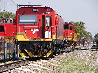
The Transnet Freight Rail Class 21E of 2014 is a South African electric locomotive.


