Morris is a town in Litchfield County, Connecticut, United States. The population was 2,256 at the 2020 census. The town is part of the Northwest Hills Planning Region.

Georgetown is a large unincorporated community in the town of Halton Hills, Ontario, Canada, in the Regional Municipality of Halton. The town includes several small villages or settlements such as Norval, Limehouse, Stewarttown and Glen Williams near Georgetown and another large population centre, Acton. In 2016, the population of Georgetown was 42,123. It sits on the banks of the Credit River, approximately 40 km west of Toronto, and is part of the Greater Toronto Area. Georgetown was named after entrepreneur George Kennedy who settled in the area in 1821 and built several mills and other businesses.
Beith is a small town in the Garnock Valley, North Ayrshire, Scotland approximately 20 miles south-west of Glasgow. The town is situated on the crest of a hill and was known originally as the "Hill o' Beith" after its Court Hill.

Eldoret is a city in the Rift Valley region of Kenya. It serves as the capital of Uasin Gishu County. Located in western Kenya, and lying south of the Cherangani Hills, the local elevation varies from about 2,100 metres (6,900 ft) at the airport to more than 2,700 metres (8,900 ft) in nearby areas.

Orange Farm ("Farma") is a township located approximately 45 km (28 mi) from Johannesburg in the Gauteng Province of South Africa. It is the southernmost township of the City of Johannesburg Metropolitan Municipality. Its name, a misnomer given that oranges are grown in orchards instead of farms, has Dutch origins. It is one of the youngest townships in South Africa, with the original inhabitants, laid-off farm workers, taking up residency in 1988. Support for the population came slowly mostly from people who were tenants at the larger township of Soweto.

Mooi River is a small town situated at 1,389 m above sea level and 160 km from the coast in KwaZulu-Natal, South Africa. The first European settlement in the area was at Mooi River Drift in 1852. This was formally named Weston in 1866 after the first Governor of Natal, Martin West.
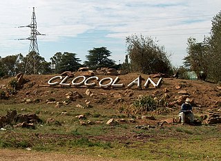
Clocolan, officially renamed Hlohlolwane, was established in 1906, is a small town in the Free State Province of South Africa. The Basotho called the place Hlohlolwane. New inhabitants mispronounced the name and called it Clocolan.

Petrus Steyn is a small farming town between Tweeling and Kroonstad, 35 km north-east of Lindley in the Free State province of South Africa. It is at the centre of an agricultural area known for wheat, maize, sunflower, potato, cattle, hunting, sheep production and forms part of the breadbasket in the Free State. It is the highest town above sea level in the Free State. Farming industries in Petrus Steyn provide potatoes worldwide.
Reitz is a small maize, wheat and cattle farming town located in the east of the Free State province of South Africa.
Rosendal is a small farming town and arts colony 45 km north of Ficksburg in the Free State province of South Africa which was founded in 1908. It has become a popular tourist destination, known for spectacular scenery, including the surrounding Witteberg mountains, and is home to a community of artists and small business owners. The town has a number of attractive buildings and restored early-20th-century homes. The quality of architectural design for newly built homes is notable, adding to the town's attractive character. This includes a number of "Tiny Homes" - less than 100 square meters - and which has earned Rosendal a reputation for becoming South Africa's tiny home capital. There are several art galleries, cafes and good restaurants as well as a heritage district of restored buildings in the former downtown. Until recently live theatre was hosted here by well known Afrikaans language actor, Chris Van Niekerk.
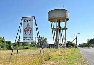
Koppies is a small town situated near the Renoster River in the Free State province of South Africa.

Middelburg is a large farming and industrial town in the South African province of Mpumalanga.
White River is a small holiday and farming town situated just north of Mbombela in Mpumalanga, South Africa. The farms in the region produce tropical fruits, macadamia nuts, vegetables, flowers and timber. As of 2011, White River had a population of 16,639.

Edwardsburgh/Cardinal is a township in the United Counties of Leeds and Grenville of eastern Ontario, Canada. Edwardsburgh township was first surveyed in 1783, and incorporated in 1850. The township was part of the historical Grenville County before it merged with Leeds County to form the United Counties in the 19th century.
Louis Botha Avenue is a major street in Johannesburg, South Africa. Originally part of the main road between central Johannesburg and Pretoria, it runs along through the north-eastern parts of the city from Hillbrow to Sandton, passing through numerous older suburbs, including Houghton and Orange Grove, before it becomes the Pretoria Main Road (R101) which passes the Alexandra Township and continues to Midrand and Pretoria.

Laingsburg is a town located in the Western Cape province in South Africa. It is a relatively large agricultural town in the semi-arid Great Karoo; its economy is based on farming goats, sheep, fruits, and vegetable. The town is served by two main roads, namely the N1 and the R323.

Aberdeen is a small town in the Sarah Baartman District Municipality of the Eastern Cape province of South Africa. With its numerous examples of Victorian architecture, it is one of the architectural conservation areas of the Karoo.

Carnarvon is a small town in the Northern Cape Province of South Africa.
Jamestown, officially James Calata, is a town on the N6 national road 58 km south of Aliwal North and 105 km north of Komani in the Joe Gqabi District Municipality of the Eastern Cape, South Africa. It is at the centre of a fertile sheep, cattle and wheat-farming area and was the terminus of a branch railway line from Molteno. It was named after James Wagenaar, original owner of the farm on which the town was laid out.
Marikana, also known as Rooikoppies, is a town in the Rustenburg Local Municipality, Bojanala Platinum District Municipality in the North West province of South Africa.