
The South African Republic was an independent and internationally recognised state in what is now South Africa, from 1852 to 1902.

Sausthorpe is a small village and civil parish in the East Lindsey district of Lincolnshire, England, 8 miles (13 km) east of Horncastle and 3 miles (4.8 km) north-west of Spilsby. It lies on the southern edge of the Lincolnshire Wolds – a designated Area of Outstanding Natural Beauty – in the valley of the River Lymn. Farming remains the dominant economic activity in the area. The population was 305 in the 2011 census and estimated at 306 in 2019.
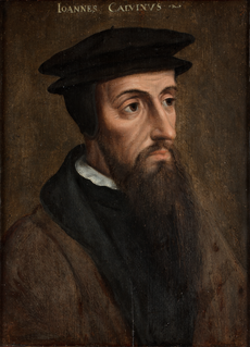
Afrikaner Calvinism is a cultural and religious development among Afrikaners that combined elements of seventeenth-century Calvinist doctrine with a "chosen people" ideology based in the Bible. It had origins in ideas espoused in the Old Testament of the Jews as the chosen people.

Amersfoort is a city and municipality in the province of Utrecht, Netherlands and is situated at the eastern edge of the Randstad. As of 1 January 2019, the municipality had a population of 156,286, making it the second-largest of the province and fifteenth-largest of the country. Amersfoort is also one of the largest Dutch railway junctions with its three stations—Amersfoort Centraal, Schothorst and Vathorst—due to its location on two of the Netherlands' main east to west and north to south railway lines. The city was used during the 1928 Summer Olympics as a venue for the modern pentathlon events. Amersfoort marked its 750th anniversary as a city in 2009.
Vaals is a town in the extreme southeastern part of the Dutch province of Limburg, which is in the southeastern part of the Netherlands.

The Orange River is a river in Southern Africa. It is the longest river within the borders of South Africa and the Orange River Basin extends extensively from Lesotho into South Africa and Namibia to the north. It rises in the Drakensberg mountains in Lesotho, flowing westwards through South Africa to the Atlantic Ocean. The river forms part of the international borders between South Africa and Lesotho and between South Africa and Namibia, as well as several provincial borders within South Africa. Except for Upington, it does not pass through any major cities. The Orange River plays an important role in the South African economy by providing water for irrigation and hydroelectric power. The river was named the Orange River in honour of the Dutch ruling family, the House of Orange, by the Dutch explorer Robert Jacob Gordon. Other names include simply the word for river, in Khoekhoegowab orthography written as !Garib, which is rendered in Afrikaans as Gariep River with the intrusion of a velar fricative in place of the alveolar click, Groote River or Senqu River, derived from ǂNū "Black".

The Vaal River is the largest tributary of the Orange River in South Africa. The river has its source near Breyten in Mpumalanga province, east of Johannesburg and about 30 kilometres (19 mi) north of Ermelo and only about 240 kilometres (150 mi) from the Indian Ocean. It then flows westwards to its conjunction with the Orange River southwest of Kimberley in the Northern Cape. It is 1,120 kilometres (700 mi) long, and forms the border between Mpumalanga, Gauteng and North West Province on its north bank, and the Free State on its south.

The Boer Republics were independent, self-governing republics formed by Dutch-speaking inhabitants of the Cape Colony and their descendants. The founders - variously named Trekboers, Boers and Voortrekkers - settled mainly in the middle, northern, north-eastern and eastern parts of present-day South Africa. Two of the Boer Republics achieved international recognition and complete independence: the South African Republic and the Orange Free State. The republics did not provide for the separation of church and state, initially allowing only the Dutch Reformed Church, and later also other churches in the Calvinist Protestant tradition. The republics came to an end after the Second Boer War of 1899-1902, which resulted in British annexation and later incorporation of their lands into the Union of South Africa.

Potchefstroom is an academic city in the North West Province of South Africa. It hosts the Potchefstroom Campus of the North-West University. Potchefstroom is on the Mooi Rivier, roughly 120 km (75 mi) west-southwest of Johannesburg and 45 km (28 mi) east-northeast of Klerksdorp. Potchefstroom, together with Rustenburg, is the second-largest city in the North West Province. The largest city, Klerksdorp, is about 45 kilometres (28 mi) away.
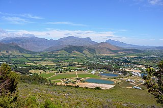
Franschhoek is a small town in the Western Cape Province and one of the oldest towns of the Republic of South Africa. It is about 75 kilometres from Cape Town and has a population of slightly over 17,000 people. Since 2000, it has been incorporated into Stellenbosch Municipality.

Vanderbijlpark is an industrial city with approximately 75 000 inhabitants, and 95 000 inhabitants in the metropole, situated on the Vaal River in the south of Gauteng province, South Africa. The city is named after Hendrik van der Bijl, an electrical engineer and industrialist.

Winburg is a small mixed farming town in the Free State province of South Africa.

Deneysville is a small town on the banks of the Vaal Dam in the Free State province of South Africa.

Parys is a town situated on the banks of the Vaal River in the Free State province of South Africa. The name of the town is the Afrikaans translation of Paris. The name was given by a German surveyor named Schilbach who had participated in the siege of Paris during the Franco-Prussian War and the location next to the Vaal reminded him of Paris on the River Seine. The area of Parys also includes the two townships Tumahole and Schonkenville.

Smithfield is a small town founded in 1848 in the Orange River Sovereignty. The town situated in a rural farming district, and is the third oldest town in present-day Free State,.

Warrenton is an agricultural town of approximately 18,000 people in the Northern Cape province of South Africa, situated 70 kilometres (40 mi) north of Kimberley on the Vaal River.

Heidelberg is a town in the Western Cape, South Africa. It is located near South Africa's south coast, on the N2 highway, 274 km east of Cape Town. Heidelberg is just east of the Overberg region, and some consider it the beginning of the Garden Route. Heidelberg is part of the Hessequa Local Municipality. Fourie House on Fourie Street is the oldest house in Heidelberg.

Barrydale is a village located on the border of the Overberg and Klein Karoo regions of the Western Cape Province in South Africa. Named after Joseph Barry, a well known merchant of the 19th century it is situated at the northern end of the Tradouw's pass which winds its way through the mountains to Swellendam.
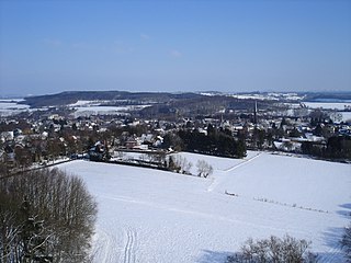
Leusden-Zuid is a village in the Dutch province of Utrecht. It is a part of the municipality of Leusden, and lies about 6 km south of Amersfoort.
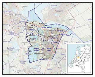
The Gooi is an area around Hilversum, in the centre of the Netherlands. It is a slightly hilly area characterised by its green landscape, its historical charm, the wealth of its inhabitants, and its villas. The Gooi is known in the Netherlands as the home of the rich and famous.


