
Telluride is the county seat and most populous town of San Miguel County in the southwestern portion of the U.S. state of Colorado. The town is a former silver mining camp on the San Miguel River in the western San Juan Mountains. The first gold mining claim was made in the mountains above Telluride in 1875, and early settlement of what is now Telluride followed. The town itself was founded in 1878 as "Columbia", but due to confusion with a California town of the same name, was renamed Telluride in 1887 for the gold telluride minerals found in other parts of Colorado. These telluride minerals were never found near Telluride, but the area's mines for some years provided zinc, lead, copper, silver, and other gold ores.
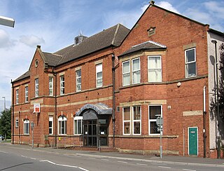
Staveley is a former mining town in the borough of Chesterfield, Derbyshire, England, alongside the River Rother, between Eckington to the north, Barlborough to the east, Sutton cum Duckmanton to the south and Brimington to the west.
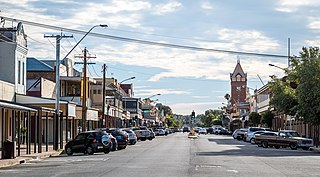
Broken Hill is an inland mining city in the far west of outback New South Wales, Australia. It is near the border with South Australia on the crossing of the Barrier Highway (A32) and the Silver City Highway (B79), in the Barrier Range. It is 315 m (1,033 ft) above sea level, with a hot desert climate, and an average rainfall of 235 mm (9 in). The closest major city is Adelaide, the capital of South Australia, which is more than 500 km (311 mi) to the southwest and linked via route A32.

Coober Pedy is a town in northern South Australia, 846 km (526 mi) north of Adelaide on the Stuart Highway. The town is sometimes referred to as the "opal capital of the world" because of the quantity of precious opals that are mined there. Coober Pedy is renowned for its below-ground dwellings, called "dugouts", which are built in this fashion due to the scorching daytime heat.

KwaZulu-Natal is a province of South Africa that was created in 1994 when the Zulu bantustan of KwaZulu and Natal Province were merged. It is located in the southeast of the country, with a long shoreline on the Indian Ocean and sharing borders with three other provinces and the countries of Mozambique, Eswatini and Lesotho. Its capital is Pietermaritzburg, and its largest city is Durban. It is the second-most populous province in South Africa, with slightly fewer residents than Gauteng.
Ponferrada is a city of Spain, located in the autonomous community of Castile and León. Ponferrada, the second most populated municipality of the Province of León, is also the capital city of El Bierzo, the only comarca recognized as an administrative entity by law in the region.

Springs is a former independent city, on the East Rand, now part of the Ekurhuleni in the Gauteng province of South Africa. It lies 50 km (31 mi) east of Johannesburg and 72 km (45 mi) southeast from Pretoria. The name of Springs derives from the large number of springs in the area; it has an estimated population of more than 121,610 in 2011 and is situated at 1628 m (5,340 ft) a.s.l.

Ndola is the third largest city in Zambia and third in terms of size and population, with a population of 475,194, after the capital, Lusaka, and Kitwe, and the second largest in terms of infrastructure development. It is the industrial and commercial center of the Copperbelt, Zambia's copper-mining region, and capital of Copperbelt Province. It lies just 10 kilometres (6.2 mi) from the border with DR Congo. It is also home to Zambia's first modern stadium, the Levy Mwanawasa Stadium.
Meander is a rural locality and town in the local government area of Meander Valley in the Launceston region of Tasmania. The locality is about 34 kilometres (21 mi) south-west of the town of Westbury. The 2016 census has a population of 328 for the state suburb of Meander.

Bracknell is a rural locality and town in the local government areas of Meander Valley and Northern Midlands in the Launceston and Central regions of Tasmania. The locality is about 22 kilometres (14 mi) south-east of the town of Westbury. The 2016 census has a population of 459 for the state suburb of Bracknell.
Aberbargoed is a town in the County Borough of Caerphilly, Wales. Aberbargoed once contained the largest ever colliery waste tip in Europe, although this has now been reclaimed and turned into a country park. The town is within the historic boundaries of Monmouthshire.

Carrick is a small historic village 17 kilometres (11 mi) west of Launceston, Tasmania, Australia, on the banks of the Liffey River. The Meander Valley Highway passes through the town's centre; this road was formerly the main road from Launceston to Deloraine and Devonport. Carrick has a well-preserved 19th-century heritage; fifteen of its colonial buildings are listed on the Tasmanian Heritage Register including Carrick House (1840), St Andrew's Church (1848), the Old Watch house (1837), Monds Roller Mill (1846) and the Carrick Hotel (1833).
Teralba is a town and suburb of Greater Newcastle, City of Lake Macquarie in New South Wales, Australia, between the towns of Speers Point and Booragul on the northern shoreline of Lake Macquarie. The town first came into being with the construction of the Homebush to Waratah Railway in the early 1880s.

Raghunathpur is a city and a municipality in Purulia district in the state of West Bengal, India. It is the headquarters of the Raghunathpur subdivision. Industrial City Raghunathpur is located near Adra on the North-East part of Purulia district. It is connected with other cities through five main way road's, which are Purulia – Barakar road, Raghunathpur-Adra-Hura road, Raghunathpur-Chas road, Cheliyama road and Raghunathpur-Bankura road. The nearest main junction stations are Joychandi Pahar railway station and Adra Junction railway station.

Ashington is a town and civil parish in Northumberland, England, with a population of 27,864 at the 2011 Census. It was once a centre of the coal mining industry. The town is 15 miles (24 km) north of Newcastle upon Tyne, west of the A189 and bordered to the south by the River Wansbeck. The North Sea coast at Newbiggin-by-the-Sea is 3 miles (5 km) away.

Goose Lake Prairie State Natural Area is a 2,537-acre (1,027 ha) state park and listed state nature preserve. More than half of the state park is a tallgrass prairie maintained as a natural area of Illinois. It is located in Grundy County near the town of Morris, approximately 50 miles (80 km) southwest of Chicago.
Grootvlei Power Station in Grootvlei, Mpumalanga, South Africa.

Irishtown Nature Park is a small man-made park between Irishtown and Sandymount Strand in Dublin 4, Ireland that offers several kilometres of walking trails along the Poolbeg Peninsula.

Kriel is a town in Nkangala District Municipality in the Mpumalanga province of South Africa. The Kriel Power Station is located just outside town.
The Osukuru Industrial Complex, sometimes referred to as Sukulu Industrial Complex, is a set of related industries, in the mining and manufacturing sectors, under construction in Uganda, the third-largest economy in the East African Community.


