Lockington, Victoria

Last updated

Lockington
Victoria
Lockington Hotel.JPG
Lockington Hotel
Australia Victoria Campaspe Shire location map.svg
Red pog.svg
Lockington
Coordinates 36°16′0″S144°32′0″E / 36.26667°S 144.53333°E / -36.26667; 144.53333
Population808 (2016 census) [1]
Postcode(s) 3563
Location
LGA(s) Shire of Campaspe
State electorate(s) Murray Plains
Federal division(s) Nicholls

Lockington is a town in northern Victoria, Australia in the Shire of Campaspe local government area, 198 kilometres north of the state capital, Melbourne. At the 2016 census, Lockington had a population of 808. [1]

Contents

History

For over 26,000 years, the Dja Dja Wurrung, Taungurung and Yorta Yorta people had made the area around Lockington their home. [2] Prior to early settlement, these groups were the primary custodians of the land, maintaining it whilst also practising their culture upon it.

The first trace of European settlement can be traced back to the 1840s when it was owned by squatters under lease-hold tenure. [3] At the time the whole area surrounding the present location of Lockington, an area made up of approximately 42,000 hectares, was known as Pine Grove and was owned by John Hunter Patterson. This land would go on to be sub-divided into East and West in 1864. The East was owned by Myles Patterson, who went on to sell it to Hugh and Robert John Glass in 1867. The East went on to switch ownership two more times, first going to Adam Burness in 1867 and then to W.J. Clarke in 1871. [3] The West part of the division in 1864 was owned by W.H. and J.H Robertson, who went on to sell it to Blackwood and Ibbotson in 1867. By 1876 it was owned by J.H. Wheeler.

With the discovery of gold and the Victorian Gold Rush occurring in the 1850s, many people came to Pine Grove in hopes of finding their fortune. [4] However with the gold rush subsiding in the 1860s, unemployment within the area rose drastically leading to multiple requests by locals to the state government to allow for farming. With the approval for farming being granted, there was another influx of people into Pine Grove in 1873. This in turn also led to the majority of Aboriginal tribes around the area to disappear. [3] 3 years later the Lockington Post Office was opened on 2 May 1876 as originally being called Pannoobamawm. [5] With the expansion of farming in the area, challenges around water supply would commonly be present, despite the creation of dams which in turn led to wells becoming an important source of water. As the area continued to grow, new schools were established but were moved around depending on the number of children in the specific districts. After the severe drought of the 1890s in Victoria, there were multiple attempts to create irrigation schemes for the state. [4] Whilst construction of the first system would not begin until 1902, the Victorian government had made it one of their top priorities, passing legislation in 1904 to help support the constructions. Despite this effort it wouldn't be until 1911 that Pine Grove would get its first irrigation system.

In a few years after the construction of the irrigation system, the Elmore to Cohuna railway was completed in 1915 to help facilitate economic growth in Pine Grove. With the train station being named Bamawm and the post office having the name Pannoobamawm, rail authorities requested a list of names to be submitted to them to help create an official name for the township. [4] The locals of the area eventually suggested the town be named after William Lockington, a prominent Jesuit priest in the early 20th century. [6] With no other places holding such a name, Lockington was officially gazetted in 1921.

The Town today

Lockington has one pub, a school, three churches and a small range of shops. The district features an extensive network of irrigation channels and these are said to feature the giant "Loch Ness yabby". [7]

Together with its neighbouring township Bamawm, Lockington has an Australian Rules football team (Lockington Bamawm United) competing in the Heathcote District Football League which won consecutive premierships in 2011/2012/2013/2014, led by coach Kahl Oliver, captained by Nathan O’Brien. [8]

Golfers play at the course of the Lockington Golf Club on Middleton Road. [9]

Notable residents

Related Research Articles

<span class="mw-page-title-main">Bendigo</span> City in Victoria, Australia

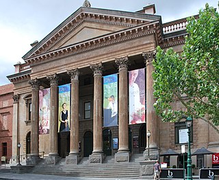
Bendigo is a city in Victoria, Australia, located in the Bendigo Valley near the geographical centre of the state and approximately 150 kilometres (93 mi) north-west of Melbourne, the state capital.

<span class="mw-page-title-main">Echuca</span> Town in Victoria, Australia

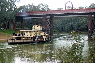
Echuca is a town on the banks of the Murray River and Campaspe River in Victoria, Australia. The border town of Moama is adjacent on the northern side of the Murray River in New South Wales. Echuca is the administrative centre and largest settlement in the Shire of Campaspe. As of the 2021 census, Echuca had a population of 15,056, and the population of the combined Echuca and Moama townships was 22,568.

<span class="mw-page-title-main">Shepparton</span> City in Victoria, Australia

Shepparton is a city located on the floodplain of the Goulburn River in northern Victoria, Australia, approximately 181 kilometres (112 mi) north-northeast of Melbourne. As of the 2021 census, the estimated population of Shepparton, including the adjacent town of Mooroopna, was 53,841.

<span class="mw-page-title-main">Castlemaine, Victoria</span> City in Victoria, Australia

Castlemaine is a small city in Victoria, Australia, in the Goldfields region about 120 kilometres northwest by road from Melbourne and about 40 kilometres from the major provincial centre of Bendigo. It is the administrative and economic centre of the Shire of Mount Alexander. The population at the 2021 Census was 7,506. Castlemaine was named by the chief goldfield commissioner, Captain W. Wright, in honour of his Irish uncle, Viscount Castlemaine.

<span class="mw-page-title-main">Mooroopna</span> Town in Victoria, Australia

Mooroopna is a rural town located 181 kilometres (112 mi) north of Melbourne, Victoria, Australia. It is on the banks of the Goulburn River opposite the larger town of Shepparton. The Midland Highway crosses the river between the two towns. At the 2016 census, Mooroopna had a population of 7,942.

<span class="mw-page-title-main">Kyneton</span> Town in Victoria, Australia

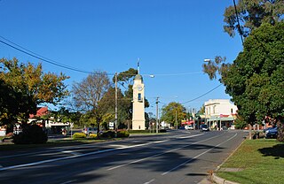
Kyneton is a town in the Macedon Ranges region of West Central Victoria, Australia. The Calder Freeway bypasses Kyneton to the north and east. Kyneton is on Dja Dja Wurrung, Taungurung and Wurundjeri Woi Wurrung country.

<span class="mw-page-title-main">Rochester, Victoria</span> Australian town

Rochester is a small town in rural Victoria, Australia. It is located 180 km (110 mi) north of Melbourne with a mixture of rural and semi-rural communities on the northern Campaspe River, between Bendigo and the Murray River port of Echuca. At the 2021 census, Rochester had a population of 3,154.

<span class="mw-page-title-main">St Arnaud, Victoria</span> City in Victoria, Australia

St Arnaud is a town in the Wimmera region of Victoria, Australia, 244 kilometres north west of the capital Melbourne. It is in the Shire of Northern Grampians local government area. At the 2021 census, St Arnaud had a population of 2,318.

<span class="mw-page-title-main">North Central Victoria</span> Region in Victoria, Australia

North Central Victoria is a rural region in the Australian state of Victoria. The region lies to the south of the Victorian/New South Wales border as defined by the Murray River, to the southwest of the Hume region, to the west of the Great Dividing Range contained within the Central Highlands and Victorian Alps, to the north of Greater Melbourne, to the northeast of the Wimmera, and to the east of the Mallee region.

<span class="mw-page-title-main">Woodend, Victoria</span> Town in Victoria, Australia

Woodend is a town in Victoria, Australia. The town is in the Shire of Macedon Ranges local government area on Dja Dja Wurrung country and is bypassed to the east and north by the Calder Freeway (M79), located about halfway between Melbourne and Bendigo. At the 2021 census, Woodend had a population of 6,732.

<span class="mw-page-title-main">Goulburn Valley</span>

The Goulburn Valley is a sub-region, part of the Hume region of the Australian state of Victoria. The sub-region consists of those areas in the catchment of the Goulburn River and other nearby streams, and is part of the Murray-Darling Basin. The Goulburn Valley is bordered on the south by the Great Dividing Range and to the north by the Murray River, the state border with New South Wales. The sub-region is one of Australia's most productive and intensively farmed areas and is predominantly irrigated.

<span class="mw-page-title-main">Axedale</span> Town in Victoria, Australia

Axedale is a small town in Victoria, Australia. It is located on the McIvor Highway, in the City of Greater Bendigo, east of Bendigo. It was surveyed and proclaimed in 1861. At the 2016 census, Axedale had a population of 802.

<span class="mw-page-title-main">Chiltern, Victoria</span> Town in Victoria, Australia

Chiltern is a town in Victoria, Australia, in the northeast of the state between Wangaratta and Wodonga, in the Shire of Indigo. At the 2021 census, Chiltern had a population of 1,580. It was the birthplace of Prime Minister John McEwan. The town is close to the Chiltern-Mount Pilot National Park. Chiltern was once on the main road between Melbourne and Sydney but is now bypassed by the Hume Freeway running one kilometre to the south.

<span class="mw-page-title-main">Malmsbury, Victoria</span> Town in Victoria, Australia

Malmsbury is a town in central Victoria, Australia on the Old Calder Highway (C794), 95 km north-west of the state capital, Melbourne and 11 km north-west of Kyneton. Situated close by the Coliban River, Malmsbury has a population of 1,101. Malmsbury is in the north western area of the Shire of Macedon Ranges local government area.

<span class="mw-page-title-main">County of Bendigo</span> Cadastral in Victoria, Australia

The County of Bendigo is one of the 37 counties of Victoria which are part of the cadastral divisions of Australia, used for land titles. It includes the city of Bendigo. It is bounded by the Campaspe River in the east, and the Loddon River in the west. The county was proclaimed in 1869.

<span class="mw-page-title-main">Baynton, Victoria</span> Town in Victoria, Australia

Baynton is a locality in central Victoria, Australia. Baynton is approximately 20 km (12 mi) north-east of Kyneton, and 20 km (12 mi) north-west of Lancefield. Baynton's elevation varies from 450 to 650 metres (1,475–2,130 ft) above sea level, and rainfall averages 675 millimetres (26.6 in) per annum. Agriculturally the region produces wool, lamb, beef and wine. Baynton is home to several wineries, and tourism has become an important component of the region's economy.

The Heathcote District Football League (HDFL) is an Australian rules football league based in the Heathcote region and major Bendigo area with clubs based in the regions of City of Greater Bendigo, Shire of Campaspe, and Shire of Gannawarra

<span class="mw-page-title-main">Toolleen</span> Town in Victoria, Australia

Toolleen is a town in northern Victoria, Australia. The town is on the Northern Highway and is in the Shire of Campaspe and the City of Greater Bendigo local government areas, 142 kilometres (88 mi) north of the state capital, Melbourne. At the 2016 census, Toolleen and the surrounding area had a population of 182.

Bamawm is a district in the Australian state of Victoria. The district is located in the Campaspe Shire local government area, 215 kilometres (134 mi) north of the state capital, Melbourne. At the 2011 census, Bawmawm and the surrounding area had a population of 527. Bamawm shares a cricket club with Lockington, their home ground is the Bamawm sports stadium.

<span class="mw-page-title-main">Tennyson, Victoria</span> Town in Victoria, Australia

Tennyson is a locality in north central Victoria, Australia. The locality is in the Shire of Campaspe, 209 kilometres (130 mi) north west of the state capital, Melbourne.

References

  1. 1 2 "2016 Census QuickStats Lockington". Australian Bureau of Statistics. Retrieved 9 February 2019.
  2. "Proud past // Campaspe Shire Council". www.campaspe.vic.gov.au. Retrieved 24 November 2019.
  3. 1 2 3 Stevens, Fae; O'Brien, Elizabeth (1967). Then ... The Water Wheel Turned. Bendigo: Cambridge Press. p. 7.
  4. 1 2 3 Dullard, Frank (1997). Endurance and Motivation "Survives". Echuca: KVM Printing.
  5. Phoenix Auctions History. "Post Office List" . Retrieved 8 April 2021.
  6. O'Kelly, G. J. (1986). "Lockington, William Joseph (1871 - 1948)". Australian Dictionary of Biography, Online Edition. Australian National University . Retrieved 3 June 2007.
  7. "LOCKINGTON". Campaspe Shire Council. Retrieved 3 June 2007.
  8. West, Luke (7 June 2019). "HDFNL - Reinvigorated O'Brien buoyed by Cats youngsters ahead of 150th". Bendigo Advertiser .
  9. Golf Select. "Lockington" . Retrieved 11 May 2009.

Commons-logo.svg Media related to Lockington, Victoria at Wikimedia Commons