
Amelia County is a county located just southwest of Richmond in the Commonwealth of Virginia, United States. The county is located in Central Virginia and is included in the Greater Richmond Region. Its county seat is Amelia Court House.
U.S. Route 360 is a spur route of US 60. The U.S. Highway runs 225.3 miles (362.6 km), entirely within the state of Virginia, from US 58 Business, Virginia State Route 293, and SR 360 in Danville east to SR 644 in Reedville. US 360 connects Danville, South Boston, Keysville and Burkeville in Southside Virginia with the state capital of Richmond. The highway connects Richmond with Tappahannock on the Middle Peninsula and the eastern Northern Neck, where it serves as the primary route through Northumberland County. US 360 is a four-lane divided highway for almost all of its length.

Morven is a rural unincorporated community in northwestern Amelia County just south of the Appomattox River in the U.S. state of Virginia. It is located in Leigh District at the intersection of SR 681 and SR 616, northwest of Flat Creek. The name is sometimes written as "Moryen", probably a misspelling. A portion of the segment of U.S. Bicycle Route 1 that runs southwest from Richmond follows SR 616 through Morven.
State Route 24 is a primary state highway in the U.S. state of Virginia. The state highway runs 89.57 miles (144.15 km) from U.S. Route 221 and SR 116 in Roanoke east to US 60 in Mt. Rush. SR 24 connects Roanoke with several small communities in southern Bedford County and central Campbell County. The state highway also runs concurrently with US 460 west of Appomattox and passes through Appomattox Court House National Historical Park, which is the site of Robert E. Lee's final stand and surrender in the American Civil War.

State Route 153 is a primary state highway in the U.S. state of Virginia. The state highway runs 17.15 miles (27.60 km) from U.S. Route 460 near Blackstone north to US 360 near Winterham. SR 153 is the primary north–south highway of eastern Amelia County. The state highway also provides a connection between Blackstone and Richmond in conjunction with US 360.
Deep Creek is a 30.1-mile-long (48.4 km) tributary of the Appomattox River in the U.S. state of Virginia. It rises in Nottoway County northwest of Crewe 0.5 miles west of State Route 49 and flows northeast into Amelia County. SR 153, crosses Deep Creek 3.66 mi southwest of the creek's mouth. Deep Creek joins the Appomattox River 23 miles (37 km) west of Petersburg.
Flat Creek is a 34.0-mile (54.7 km) right-bank tributary of the Appomattox River in the U.S. state of Virginia. It rises just east of the town of Burkeville in Nottoway County and flows north into Amelia County, then northeast to join the Appomattox River just outside the village of Coverly 28 miles (45 km) northwest of Petersburg.
Jetersville is a mostly rural unincorporated community in southwestern Amelia County in the U.S. state of Virginia, just off US 360. The town is centered around the intersection of SR 671 and SR 640. The Norfolk Southern Railway runs along the main roads.
Ammon is a rural unincorporated community in the southeastern corner of Amelia County in the U.S. state of Virginia. It is located in Jackson District on SR 600 between SR 610 and SR 622. The portion of the border of Dinwiddie and Nottoway counties that is formed by Namozine Creek is 1.5 miles (2.4 km) to the southeast. The nearest volunteer fire department to Ammon is at Mannboro, 5 miles northwest.
Chula is a mostly rural unincorporated community in the northeastern part of Amelia County just west of the Appomattox River in the U.S. state of Virginia. The town is centered around the T-intersection of SR 636 and SR 740 in Giles District. Chula is just west of SR 604, which includes a short bypass segment built around the town in the late 20th century. The area is served by the post office 7 miles southwest at Amelia Court House, ZIP code 23002. The nearest fire station to Chula is Amelia County Volunteer Fire Department Station 4, near Mattoax, 3 miles north.
Coverly is a rural unincorporated community in northeastern Amelia County in the U.S. state of Virginia. The town is located on SR 631 off SR 604 at Coverly, a farm and historic home built in the 1830s, atop a hill with the Appomattox River to the east, Flat Creek to the south, and the Norfolk Southern Railway to the northwest. The railroad, originally the Richmond and Danville, crosses Route 631 between the village and Route 604. The community of Chula lies 2 miles southwest, and Mattoax and Masons Corner approximately 2 miles north. The area is served by the post office at Amelia Court House, the county seat, 8 miles southwest of Coverly, and by the volunteer fire department at Mattoax.
Deatonville is a rural unincorporated community in the western part of Amelia County in the U.S. state of Virginia. It is located in Leigh District along SR 616 at its junctions with SR 617. Deatonville straddles the boundary between ZIP codes 23083 (Jetersville) and 23966 (Rice). A portion of the segment of U.S. Bicycle Route 1 that runs southwest from Richmond follows SR 616 through Deatonville.
Earls is a rural unincorporated community in southeastern Amelia County in the U.S. state of Virginia. It is located in Jackson District along SR 153 at the southern terminus of SR 641, 1 mile (1.6 km) north of the Amelia–Nottoway county line.

Gills is a rural unincorporated community in Amelia County in the U.S. state of Virginia. It is located in Leigh District around the intersections of SR 616 with SR 657, 1 mile (1.6 km) north of the Nottoway county line. Gills is situated at the highest point in Amelia County, 527 feet (161 m) above sea level, and is also the westernmost extant hamlet in the county. A portion of the segment of U.S. Bicycle Route 1 that runs southwest from Richmond follows SR 616 through Gills.
Maplewood is a mostly rural unincorporated community in southwest central Amelia County in the U.S. state of Virginia. It is located at the intersection of SR 640/SR 697 and SR 640, just off the four-lane current US 360. Maplewood straddles the border between ZIP codes 23002 and 23083 (Jetersville). The nearest volunteer fire station is Amelia County Volunteer Fire Department Co. 3, at Jetersville, just over 2 miles southwest.
Namozine is a rural unincorporated community near the eastern extremity of Amelia County, just south of the Appomattox River in the U.S. state of Virginia. It is the easternmost hamlet in the county and is situated around the intersections of SR 708 with SR 623 and SR 622. Roughly 2 miles to the southeast, Namozine Creek forms the county line, flowing northeast into the Appomattox at Lake Chesdin.

Paineville is a rural unincorporated community in western Amelia County in the U.S. state of Virginia. It is located in Leigh District around the intersections of SR 616 with SR 644. Paineville straddles the border of ZIP codes 23002 and 23083 (Jetersville). The community has its own fire station, Amelia County Volunteer Fire Department Company 5. A portion of the segment of U.S. Bicycle Route 1 that runs southwest from Richmond follows SR 616 through Paineville.

Rodophil is a rural unincorporated community in western Amelia County in the U.S. state of Virginia. It is located in Leigh District at the intersection of SR 616 and the southern terminus of SR 620. It straddles the border of ZIP codes 23002 and 23083. Rodophil is served by Amelia County Volunteer Fire Department Company 5, in Paineville, 3 miles northeast. A portion of the segment of U.S. Bicycle Route 1 that runs southwest from Richmond follows SR 616 through Rodophil.

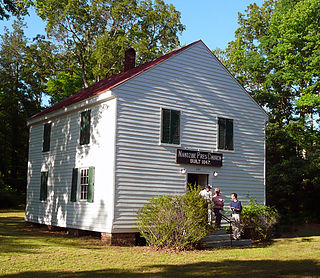
The Wigwam is a landmark home, of Cape Cod style, built in 1790, close to the Appomattox River near Lodore on Rt. 637, in Amelia County, Virginia. Governor William Branch Giles (1762-1830) built the house and made it his home until his death, and it later became a home for the Harrison family.


