Londonderry, North Yorkshire

Last updated

Londonderry
Village street, Londonderry, Yorkshire.jpg
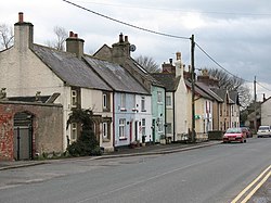
Village street in Londonderry
North Yorkshire UK location map (2023).svg
Red pog.svg
Londonderry
Location within North Yorkshire
Civil parish
Unitary authority
Ceremonial county
Region
Country England
Sovereign state United Kingdom
Post town NORTHALLERTON
Postcode district DL7
Dialling code 01677
Police North Yorkshire
Fire North Yorkshire
Ambulance Yorkshire
UK Parliament
List of places
UK
England
Yorkshire
54°17′05″N1°31′58″W / 54.284793°N 1.532706°W / 54.284793; -1.532706

Londonderry is a village near the Yorkshire Dales, England situated 4 miles (6 kilometres) south-east of Bedale, almost on the A1 road. [1] It was part of the Hambleton District of North Yorkshire and is in the historic North Riding of Yorkshire.

Contents

It is named after the Marquesses of Londonderry, who took their name from County Londonderry, now in Northern Ireland, and were colliery owners in this area of England. [2]

Londonderry Lodge was a former Transport Café in the village. The café is now closed, having served the traffic on the A1 road for 100 years. [3] [4] The building has been listed as Grade II since 1966. [5] With the upgrading of the A1 to A1(M) standard, the junction with the A1 was diverted away from Londonderry (with even the new service road, the A6055, taking a route west of the new road as opposed to going through the hamlet). As a consequence of this, traffic has been lost from the hamlet, lorry traffic especially so. A noted refuelling service station have moved their business from Londonderry to Leeming Bar because of this traffic shift. [6]

See also

Related Research Articles

The A1, also known as the Great North Road, is the longest numbered road in the United Kingdom, at 410 miles (660 km). It connects London, the capital of England, with Edinburgh, the capital of Scotland. The numbering system for A-roads, devised in the early 1920s, was based around patterns of roads radiating from two hubs at London and Edinburgh. The first number in the system, A1, was given to the most important part of that system: the road from London to Edinburgh, joining the two central points of the system and linking the UK's (then) two mainland capital cities. It passes through or near north London, Hatfield, Stevenage, Baldock, Biggleswade, Peterborough, Stamford, Grantham, Newark-on-Trent, Retford, Doncaster, Pontefract, York, Wetherby, Ripon, Darlington, Durham, Gateshead, Newcastle upon Tyne, Morpeth, Alnwick, Berwick-upon-Tweed, Dunbar, Haddington, Musselburgh, and east Edinburgh.

Scotch Corner is a junction of the A1(M) and A66 trunk roads near Richmond in North Yorkshire, England. It has been described as "the modern gateway to Cumbria, the North East and Scotland", and is a primary destination signed from as far away as the M6 motorway, 50 miles away. The junction's name is derived from the fact that it is the point of divergence for traffic coming from London, the East Midlands and Yorkshire wishing to continue either to Edinburgh and eastern Scotland or to Glasgow and western Scotland.

<span class="mw-page-title-main">A1(M) motorway</span> Four separate motorway sections in England

A1(M) is the designation given to a series of four separate motorway sections in the UK. Each section is an upgrade to a section of the A1, a major north–south road which connects London, the capital of England, with Edinburgh, the capital of Scotland. The first section, the Doncaster Bypass, opened in 1961 and is one of the oldest sections of motorway in Britain. Construction of a new section of A1(M) between Leeming and Barton was completed on 29 March 2018, a year later than the anticipated opening in 2017 due to extensive archaeological excavations. Its completion linked the Barton to Washington section with the Darrington to Leeming Bar section, forming the longest A1(M) section overall and reducing the number of sections from five to four.

<span class="mw-page-title-main">Brompton-on-Swale</span> Village and civil parish in North Yorkshire, England

Brompton-on-Swale is a village and civil parish in the Richmondshire district of North Yorkshire, England. The village is located three miles east of Richmond and 10 miles (16 km) north-west of the county town of Northallerton on the northern bank of the River Swale.

<span class="mw-page-title-main">Burneston</span> Village and civil parish in North Yorkshire, England

Burneston is a village and civil parish in North Yorkshire, England. According to the 2001 Census it had a population of 244, increasing to 311 at the 2011 Census. The village is close to the A1(M) road and is about 4 miles (6 km) south-east of Bedale.

<span class="mw-page-title-main">A6055 road</span> A-road in North Yorkshire, England

The A6055 is a 25-mile (40 km) stretch of road in North Yorkshire that runs from Knaresborough to Boroughbridge, with a break, then starts up again at Junction 50 of the A1(M) to run parallel with A1(M) acting as a Local Access Road (LAR) going between Junction 50 and 56 at Barton. Responsibility for the route rests with the Highways Agency, as it is designated as a primary route associated with the A1(M) upgrade.

<span class="mw-page-title-main">Leeming Bar railway station</span> Railway station in North Yorkshire, England

Leeming Bar railway station is a railway station in Leeming Bar, North Yorkshire, England. It is the penultimate eastern rail passenger station of the Wensleydale Railway, though the line continues towards Northallerton. Trains are timed to link in with Dales and District service buses to Northallerton to connect with the National Rail network.

<span class="mw-page-title-main">Gatenby</span> Village and civil parish in North Yorkshire, England

Gatenby is a secluded village and civil parish in North Yorkshire, England. It is situated about two miles east of the A1(M) road, near to the River Swale. Nearby is RAF Leeming.

<span class="mw-page-title-main">Leeming Bar</span> Village in North Yorkshire, England

Leeming Bar is a village in the civil parish of Aiskew and Leeming Bar, in North Yorkshire, England. The village lay on the original Great North Road before being bypassed. It is now home to a large industrial estate and the main operating site of the Wensleydale Railway. It is in the historic North Riding of Yorkshire.

Leeming is a village in North Yorkshire, England.

<span class="mw-page-title-main">A684 road</span> A road in Northern England

The A684 is an A road that runs through Cumbria and North Yorkshire, starting at Kendal, Cumbria and ending at Ellerbeck and the A19 road in North Yorkshire. It crosses the full width of the Yorkshire Dales, passing through Garsdale and the full length of Wensleydale.

<span class="mw-page-title-main">Exelby</span> Village in North Yorkshire, England

Exelby is a village in the former Hambleton District of North Yorkshire, England. It is 2 miles (3.2 km) south-east of Bedale and 0.5 miles (0.8 km) west of the A1(M) motorway and is part of the civil parish of Exelby, Leeming and Londonderry. The civil parish had a total of 2,788 residents at the time of the 2011 census, though Exelby had only 80 homes. The name of the village derives from Old Danish or Old Norse and means Eskil's farm or Eskil's settlement.

<span class="mw-page-title-main">A6136 road</span> A-road in North Yorkshire, England

The A6136 is a 4 digit A road in North Yorkshire, England. It runs between the A6108 Queen's Road, in the market town of Richmond, before terminating on the A6055 in Catterick, near the A1(M) Junction 52.

<span class="mw-page-title-main">Exelby, Leeming and Londonderry</span> Civil parish in North Yorkshire, England

Exelby, Leeming and Londonderry is a civil parish in the former Hambleton District of North Yorkshire, England. It contains three villages – Exelby, Leeming and Londonderry – and RAF Leeming Royal Air Force station. The population of the civil parish as of the 2011 census was 2,788. The parish was renamed because it was felt that "Newton" was not recognised while Londonderry was, being a hamlet.

Gatherley Castle, sometimes referred to as a modern mansion, was located in the township of Middleton Tyas, North Yorkshire, England.

<span class="mw-page-title-main">Aiskew and Leeming Bar</span> Civil parish in North Yorkshire, England

Aiskew and Leeming Bar is a civil parish within the Bedale ward of North Yorkshire, England. The parish only has two settlements, but prior to the changes in the 19th century, the area it contains belonged to the parish of Bedale. At the 2011 Census, the population of the parish was 2,427.

<span class="mw-page-title-main">Vale of York services</span> Future motorway service area in England

The Vale of York services is a future motorway service area (MSA) on the A1(M) in North Yorkshire, England. The MSA will be located on the western side of the motorway between Junctions 48 and 49, with access to both the northbound and southbound carriageways. The planning application has been submitted multiple times between 2001 and 2021.

<span class="mw-page-title-main">Catterick services</span> Proposed motorway services in Yorkshire, England

Catterick services is a proposed motorway service area (MSA) near to Catterick village in North Yorkshire, England. The services were first proposed in 2019, receiving planning permission in 2022, and a revised permission in December 2024 due to a legal issue with the previous approval of 2022. The services have been objected to and criticised due to the location of the site as it will affect wildlife in the area. It was also objected to on the grounds of other nearby services along the stretch of the A1(M) in North Yorkshire, however, government designations state that Leeming Bar, Coneygarth, Scotch Corner and Barton Park services are all motorway rest areas (MRAs), not being of sufficient standard to be motorway service areas (MSAs).

Exelby, Leeming and Londonderry is a civil parish in the former Hambleton District of North Yorkshire, England. It contains 15 listed buildings that are recorded in the National Heritage List for England. All the listed buildings are designated at Grade II, the lowest of the three grades, which is applied to "buildings of national importance and special interest". The parish contains the villages of Exelby, Leeming and Londonderry, and the surrounding countryside. Most of the listed buildings consist of houses, farmhouses and farm buildings, and the others include a bridge, a church and a water pump.

<span class="mw-page-title-main">St John the Baptist's Church, Leeming</span> Anglican church in North Yorkshire, England

St John the Baptist's Church is an Anglican church in Leeming, North Yorkshire, a village in England.

References

  1. "Londonderry... North Yorkshire that is". www.londonderrysentinel.co.uk. 21 August 2014. Retrieved 17 January 2016.
  2. Lloyd, Chris (10 July 2015). "It's a long way to Londonderry..." The Northern Echo. Retrieved 17 January 2016.
  3. Middleton, Christopher (11 July 1997). "King of the roads". The Independent. Retrieved 17 January 2016.
  4. Lloyd, Chris (27 May 2015). "Curiosities seen from the saddle". Smallholder. Retrieved 17 January 2016.
  5. "Londonderry Lodge". British Listed Buildings. Retrieved 17 January 2016.
  6. "Exelby Services secures a £4 million finance package from HSBC". Harrogate Informer. 25 February 2014. Retrieved 17 January 2016.

Commons-logo.svg Media related to Londonderry, North Yorkshire at Wikimedia Commons