
A mulch is a layer of material applied to the surface of soil. Reasons for applying mulch include conservation of soil moisture, improving fertility and health of the soil, reducing weed growth, and enhancing the visual appeal of the area.
Puckey's Estate Reserve is a coastal nature reserve in North Wollongong, New South Wales, Australia. It is mainly she-oak forest, but also has sand dune and wetland areas, including areas along Para Creek. It is located in the suburb of Fairy Meadow and is bounded by Fairy Meadow Beach to the east, Squires Way to the west, Elliotts Road to the north and Fairy Lagoon to the south.

The University of Wisconsin–Madison Arboretum is a teaching and research facility of the University of Wisconsin–Madison and the site of historic research in ecological restoration. In addition to its 1,260 acres (5 km2) in Madison, Wisconsin, the Arboretum also manages 520 acres (210 ha) of remnant forests and prairies throughout Wisconsin. It was designated a National Historic Landmark in 2021, in recognition for its role as a pioneer in the field of ecological restoration.

Albany Hill is a prominent hill along the east shore of San Francisco Bay in the city of Albany, California. Geologically, the hill is predominantly Jurassic sandstone, carried to the western edge of North America on the Pacific Plate and scraped off there in the course of subduction. Albany Hill is part of a range of hills uplifted long before today's Berkeley Hills. These hills include Fleming Point and Point Isabel, Brooks Island, the Potrero San Pablo, and the hills across San Pablo Strait.
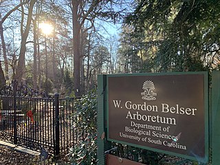
W. Gordon Belser Arboretum is part of the University of South Carolina in Columbia, South Carolina, managed by the Department of Biological Sciences. The arboretum serves as a nature preserve, field laboratory and research site for students and faculty. It is open to the public at a monthly open house. A small botanic garden features shrubs and small trees suitable for Columbia's home landscapes. The remaining landscape features southeast native trees and plant communities and is a certified Palmetto Wildlife Habitat.
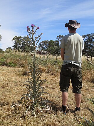
A noxious weed, harmful weed or injurious weed is a weed that has been designated by an agricultural or other governing authority as a plant that is injurious to agricultural or horticultural crops, natural habitats or ecosystems, or humans or livestock. Most noxious weeds have been introduced into an ecosystem by ignorance, mismanagement, or accident. Some noxious weeds are native. Typically they are plants that grow aggressively, multiply quickly without natural controls, and display adverse effects through contact or ingestion. Noxious weeds are a large problem in many parts of the world, greatly affecting areas of agriculture, forest management, nature reserves, parks and other open space.

Colt Creek State Park is a Florida State Park in Central Florida, 16 miles (26 km) north of Lakeland off of State Road 471. This 5,067 acre park nestled within the Green Swamp Wilderness Area and named after one of the tributaries that flows through the property was opened to the public on January 20, 2007. Composed mainly of pine flatwoods, cypress domes and open pasture land, this piece of pristine wilderness is home to many animal species including the American bald eagle, Southern fox squirrel, gopher tortoise, white-tailed deer, wild turkey and bobcat.

A weed is a plant considered undesirable in a particular situation, growing where it conflicts with human preferences, needs, or goals. Plants with characteristics that make them hazardous, aesthetically unappealing, difficult to control in managed environments, or otherwise unwanted in farm land, orchards, gardens, lawns, parks, recreational spaces, residential and industrial areas, may all be considered weeds. The concept of weeds is particularly significant in agriculture, where the presence of weeds in fields used to grow crops may cause major losses in yields. Invasive species, plants introduced to an environment where their presence negatively impacts the overall functioning and biodiversity of the ecosystem, may also sometimes be considered weeds.
Glenbrook Lagoon is a fresh water lagoon located in Glenbrook, New South Wales at the foot of the Blue Mountains. It is heritage-listed.

The Cheadle Center for Biodiversity and Ecological Restoration (CCBER) is a research center under the Office of Research at the University of California, Santa Barbara (UCSB) whose mission is to preserve regional biodiversity and restore ecosystems on campus lands. CCBER has three main functions: curation and preservation of natural history collections, native coastal ecosystem and habitat restoration on campus lands, and education and outreach for both UCSB students and local community schools.

The Land Conservancy of San Luis Obispo County (LCSLO) is a non-profit land trust organization that has been operating in San Luis Obispo County, California since 1984. The LCSLO is dedicated to the voluntary and collaborative preservation and improvement of lands that hold significant scenic, agricultural, habitat, and cultural values. Their work aims to benefit both the local community and wildlife that depends on these lands.
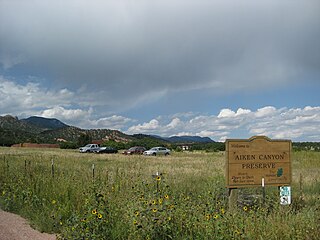
Aiken Canyon Preserve is a 1,621-acre (6.56 km2) Nature Conservancy-managed state property in Colorado. It was first observed and named after Charles Aiken, a 19th-century U.S. surveyor, pioneer, and ornithologist who first surveyed the region in the 1870s and identified more than 75 bird species. The preserve consists of foothills, shrub and woodland ecosystems and is 12.4 miles (20.0 km) southeast from Colorado Springs located on the eastern slope of the Rampart Range which is within a smaller foothill system of the Front Range. The surrounding mountain ranges of the Rampart Range and Palmer Divide created the nature preserves sustainable ecosystem. There is also a four-mile (6 km)-loop hiking trail on the preserve.
Los Cerritos Wetlands is located in both Los Angeles County and Orange County in the cities of Long Beach, California, and Seal Beach, California. The San Gabriel River, historically and currently flows through the Los Cerritos Wetlands Complex.
Friends of Five Creeks is a regional community volunteer organization founded in 1996 by Sonja Wadman originally dedicated to the stewardship of creeks in northern Alameda County and western Contra Costa, California, United States. Education about wildlife and restoration is also a major facet of the FFC's mission.

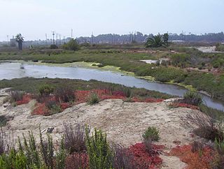
The Gardena Willows Wetland Preserve occupies 13.6 acres (55,000 m2) of land owned by the City of Gardena, in Los Angeles County, California. The preserve is the last intact remnant of the former Dominguez Slough, an important vernal marsh and riparian forest with riparian zones that once covered as much as 400 acres (1,600,000 m2) of this area, known as the South Bay region. The preserve has 9.4 acres (38,000 m2) of wetland and 4.2 acres (17,000 m2) of upland. The wetlands have a natural depression where water remains for such a significant time that plants and animals not adapted to water and saturated soils cannot survive. The upland, which remains dry outside of the rainy season, supports plants which thrive with these drier conditions. The slough is a part of the Dominguez Watershed, 96% of which is now covered with concrete and man-made structures. Located on the traditional lands of the Tongva, it is believed that these indigenous people were able to commute by canoe around much of the area. Tongva villages were located throughout much of what is now Los Angeles and Orange Counties as well as three southern Channel Islands as distant as 60 miles (97 km) from the coast of Los Angeles County.

Younger Lagoon Reserve is a 72-acre (28-hectare) University of California Natural Reserve System reserve on the northern shore of Monterey Bay in Santa Cruz County, California. The site is owned by the University of California and managed for teaching and research. It is adjacent to Long Marine Laboratory.

Limeburners Creek National Park is a protected national park on the Mid North Coast of New South Wales, Australia. The 91.2 km national park is located 5 km (3.1 mi) to the north of Port Macquarie and exists across both the Kempsey Shire and Port Macquarie-Hastings Council local government areas, but is chiefly managed by National Parks and Wildlife Service. The area was originally erected as a nature reserve but this reservation was revoked when it became formally recognised as a national park in 2010 under the National Parks and Wildlife Act (1974). Many threatened ecological habitats and species of fauna and flora are found within this park, alongside several heritage sites of cultural significance, particularly to the local Birpai and Dunghutti people upon whose land the park exists. The protected status of this national park is largely owing to the ecological and cultural value of the area, in addition to the value of the ecosystems to further scientific research.

Oxford Basin is a 10.7-acre (43,000 m2) constructed wetland and wildlife conservation area in the northwest corner of Marina del Rey, California, located between Washington Boulevard and Admiralty Way.

The San Gabriel and Lower Los Angeles Rivers and Mountains Conservancy (RMC) is an agency of the State of California in the United States with the mission of preserving open space and habitat for low-impact recreation and educational uses, wildlife habitat restoration and protection, and watershed improvements within its jurisdiction. The conservancy was created by the state legislature in 1999, and is headquartered in Azusa. It is 1 of 10 conservancies within the California Natural Resources Agency. At the time of its founding, it was the state's first conservancy to primarily serve an urban area.
Colorado Lagoon is a 29 acres (12 ha) public park in the Alamitos Heights neighborhood of Long Beach, California. It takes its name from Colorado Street, which borders the park to the south. The 18 acres (7.3 ha) lagoon the park contains is one of the only coastal salt marshes left on the West Coast.
