Prairies are ecosystems considered part of the temperate grasslands, savannas, and shrublands biome by ecologists, based on similar temperate climates, moderate rainfall, and a composition of grasses, herbs, and shrubs, rather than trees, as the dominant vegetation type. Temperate grassland regions include the Pampas of Argentina, Brazil and Uruguay, and the steppe of Ukraine, Russia, and Kazakhstan. Lands typically referred to as "prairie" tend to be in North America. The term encompasses the lower and mid-latitude of the area referred to as the Interior Plains of Canada, the United States, and Mexico. It includes all of the Great Plains as well as the wetter, hillier land to the east. From west to east, generally the drier expanse of shortgrass prairie gives way to mixed grass prairie and ultimately the richer soils of the tallgrass prairie.

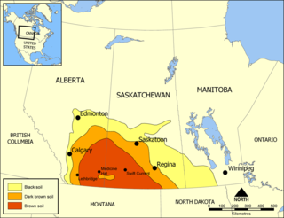
The Missouri Coteau, or Missouri Plateau, is a large plateau that stretches along the eastern side of the valley of the Missouri River in central North Dakota and north-central South Dakota in the United States. In the Canadian provinces of Saskatchewan and Alberta this physiographic region is classified as the Uplands Missouri Coteau, which is a part of the Great Plains Province or Alberta Plateau Region, which extends across the southwest corner of the province of Saskatchewan as well as the southeast corner of the province of Alberta. Historically, in Canada the area was known as the Palliser's Triangle and regarded as an extension of the Great American Desert and unsuitable for agriculture and thus designated by Canadian geographer and explorer John Palliser. The terrain of the Missouri Coteau features low hummocky, undulating, rolling hills, potholes, and grasslands. Apart from being a geographical area, the Missouri Coteau also has a cultural connection to the people of the area, the Métis people of South Dakota, along with other Indigenous groups. The history of this plateau is large, and the Missouri Coteau has a significance to these people.

Little Missouri National Grassland is a National Grassland located in western North Dakota, United States. At 1,028,051 acres (416,037 ha), it is the largest grassland in the country. Enclaved within its borders is Theodore Roosevelt National Park with an additional 70,446 acres (28,508 ha), which is managed by the National Park Service. The Little Missouri National Grassland was once a part of the Custer National Forest, but is now a part of the Dakota Prairie Grasslands, a National Forest unit consisting entirely of National Grasslands. A predominant feature of the grassland is colorful and beautiful badlands, a rugged terrain extensively eroded by wind and water. It is a mixed-grass prairie with both long and short grass.
The Rainwater Basin wetland region is a 4,200 sq mi (11,000 km2) loess plain located south of the Platte River in south-central Nebraska. It lies principally in Adams, Butler, Clay, Fillmore, Hamilton, Kearney, Phelps, Polk, Saline, Seward, and York counties and extends into adjacent areas of southeastern Hall, northern Franklin, northern Nuckolls, western Saline, northern Thayer and northwestern Webster counties. Before European settlement, this plain was covered by prairie grasslands interspersed with thousands of ephemeral playa wetlands, called Rainwater Basins. Informally and locally, individual Nebraska Rainwater Basins are referred to as rainbasins, basins, lagoons, lakes, ponds, marshes, hay marshes, and lakes marshes. To the west, a tallgrass prairie in the east once gradually transitioned into mixed grass prairie. Currently, the Rainwater Basin wetland region is covered by farms, mainly growing corn and soybeans. Several, interspersed, stream courses, of which largest is the Big Blue River and its tributaries, drain this region. Riparian woodlands and upland slopes possessing oak woodlands are associated with these streams. In the spring and fall months, millions of migratory birds pass through the region to feed and rest. Along with riparian habitats associated Platte River, Big Blue River, its tributaries, and smaller streams, Rainwater Basins are a major component of the Central Flyway of North America.

Huron Wetland Management District is located in the U.S. state of South Dakota and includes 17,518 acres (70.89 km2). The refuge borders the Missouri River on the east and is managed by the U.S. Fish and Wildlife Service. Huron WMD covers eight counties in east-central South Dakota. The topography of this area ranges from flat, gently rolling drift prairie to the Missouri Coteau hills in the western end of the district. The district lies in the midst of the Prairie Pothole Region.

Arrowwood Wetland Management District is located in the U.S. state of North Dakota. Arrowwood WMD is a part of the Arrowwood National Wildlife Refuge Complex, and is managed by the U.S. Fish and Wildlife Service. The district consists of 28 Waterfowl Production Areas, 314 Wetland easements, one easement refuge known as Johnson Lake National Wildlife Refuge and another four easements through the Farmers Home Administration, altogether totalling 28,922 acres (117 km2).

Chase Lake Wetland Management District is located in the U.S. state of North Dakota around Chase Lake. The district is located in what is known as the Prairie Pothole Region of lakes and ponds, which were left behind by the retreat of glaciers at the end of the last ice age. It was established in 1993.

The Chase Lake Prairie Project is considered the "National Flagship Project" of the North American Waterfowl Management Plan (NAWMP). The goal is to rehabilitate 5,500,000 acres (2,200,000 ha) of wetland around Chase Lake on the Missouri Coteau. The project was dedicated in September 1989.
The Valley City Wetland Management District is located in the U.S. state of North Dakota and consists of 76,000 acres (307 km2). The wetland district is a substation of the Arrowwood National Wildlife Refuge Complex, overseen by the U.S. Fish and Wildlife Service. 82 waterfowl production areas and four separate national wildlife refuges which are privately owned are in turn managed by the wetland district as easement refuges. The wetland district is in portions of 5 counties in the Prairie Pothole Region that was created by the retreat of glaciers 12,000 years ago, during the last glacial maximum. One third of the protected lands are wetlands with the balance consisting of prairie.

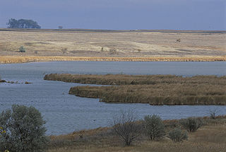
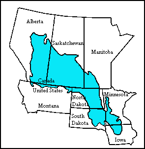
The Prairie Pothole Region is an expansive area of the northern Great Plains that contains thousands of shallow wetlands known as potholes. These potholes are the result of glacier activity in the Wisconsin glaciation, which ended about 10,000 years ago. The decaying ice sheet left behind depressions formed by the uneven deposition of till as buried ice blocks melted in ground moraines. These depressions are called potholes, glacial potholes, kettles, or kettle lakes. They fill with water in the spring, creating wetlands, which range in duration from temporary to semi-permanent. The region covers an area of about 800,000 sq. km and expands across three Canadian provinces and five U.S. states. The hydrology of the wetlands is variable, which results in long term productivity and biodiversity. The PPR is a prime spot during breeding and nesting season for millions of migrating waterfowl.
Audubon Wetland Management District is located in the U.S. state of North Dakota and consists of 123 Waterfowl Production Areas (WPAs), 8 National Wildlife Refuges (NWRs), and numerous wetland and grassland easements and over 100 separate wetland areas set aside to preserve habitat for bird, plant and mammal species. These lands contain valuable wetland and grassland habitat for waterfowl and other migratory birds, and many other species of wildlife. Scattered throughout west central and southwestern North Dakota in McLean, Ward, and Sheridan Counties, the district is managed by the U.S. Fish and Wildlife Service and from Audubon National Wildlife Refuge. Hundreds of lakes and marshlands in this region provide critical habitat for migratory and nesting bird species.

Buffalo Ridge is a large expanse of rolling hills in the southeastern part of the larger Coteau des Prairies. It stands 1,995 feet (608 m) above sea level. The Buffalo Ridge is sixty miles (97 km) long and runs through Lincoln, Pipestone, Murray, Nobles, and Rock counties in the southwest corner of Minnesota, and Minnehaha, Moody, and Lincoln counties in southeast South Dakota.

Straddling the headwaters of the Minnesota River in west-central Minnesota, Big Stone National Wildlife Refuge is within the heart of the tallgrass prairie's historic range. Today, less than one-percent of tallgrass prairie remains.
Waubay Wetland Management District is located in the "Coteau des Prairies", or prairie hills region of South Dakota. It includes more than 300 waterfowl production areas (WPAs) in six counties of northeastern South Dakota: Clark, Codington, Day, Grant, Marshall, and Roberts. The WPAs range from 40 acres (16 ha) to more than 1,600 acres (650 ha) in size, comprising a total of 40,000 acres (160 km2). WPAs provide vital wildlife habitat in a landscape of cropland and pasture.

Tewaukon National Wildlife Refuge is located in southeastern North Dakota along the western edge of the northern tallgrass prairie, about 5 miles (8.0 km) south of Cayuga, in Sargent County. The Wild Rice River flows through the Refuge and then into Lake Tewaukon. Established in 1945, the 8,363-acre (33.84 km2) Refuge is located in the Prairie Pothole Region, one of the most biologically productive areas on earth. It lies within the Tewaukon Wetland Management District.
Detroit Lakes Wetland Management District is located in northwest Minnesota and includes the counties of Becker, Clay, Mahnomen, Norman, and Polk - an area of approximately 6,000 square miles (16,000 km2). The district is divided into three general landscape areas, roughly equal in size. From west to east, these are: the Red River Valley floodplain, the glacial moraine/prairie pothole region, and the hardwood/coniferous forest. The district currently manages over 42,000 acres (170 km2) of public land in 165 waterfowl production areas (WPAs). Additionally, district staff are responsible for more than 300 wetland and upland easements on private property, totaling more than 11,000 acres (45 km2).
Devils Lake Wetland Management District is located in the heart of the Prairie Pothole Region of the United States. The District was established in 1962 to purchase and protect wetland habitat for migratory waterfowl and other wildlife in northeastern North Dakota. One of the primary objectives of Devils Lake Wetland Management District is to provide wetland and grassland habitat for waterfowl in the spring and summer for nesting and feeding. The other primary objective is to provide migration habitat for waterfowl in the spring and fall.

Located in south-central North Dakota, Kulm Wetland Management District was established in July 1971. Located in the Prairie Pothole Region of North America, Kulm Wetland Management District provides breeding, nesting, and brood rearing areas for many species of waterfowl and other migratory birds. The District currently manages 201 waterfowl production areas that total 45,683 acres (184.87 km2), 3 national wildlife refuges that are easement refuges, and 120,000 acres (490 km2) of wetland and grassland easements. The District's headquarters is in Kulm, North Dakota.
The St. Croix Wetland Management District in west-central Wisconsin, United States, encompasses a diversity of habitats lying along the eastern edge of the tallgrass prairie. Within the eight-county district, one can travel north through the high river bluffs of Pepin County, to the prairie potholes of St. Croix County, and then to the pine barrens of Burnett County.
Last Mountain Lake National Wildlife Area is a National Wildlife Area (NWA) in the Canadian province of Saskatchewan. The protected area is in the Prairie Pothole Region of North America, which extends throughout three Canadian provinces and five U.S. states. It is also within Palliser's Triangle and the Great Plains ecoregion. The site is an Important Bird Area (IBA) of Canada, designated as Last Mountain Lake NWA .


