Loriga

Last updated

Loriga
PanoramaLoriga.jpg
Loriga's Coat of Arms.jpg
Portugal location map.svg
Red pog.svg
Loriga
Location in Portugal
Coordinates: 40°19′26″N7°41′28″W / 40.324°N 7.691°W / 40.324; -7.691 Coordinates: 40°19′26″N7°41′28″W / 40.324°N 7.691°W / 40.324; -7.691
CountryFlag of Portugal.svg  Portugal
Region Centro
Intermunic. comm. Beiras e Serra da Estrela
District Guarda
Municipality Seia
Area
  Total36.25 km2 (14.00 sq mi)
Elevation
750 m (2,460 ft)
Population
 (2011)
  Total1,053
  Density29/km2 (75/sq mi)
Time zone UTC±00:00 (WET)
  Summer (DST) UTC+01:00 (WEST)
Postal code
6270
Area code 238
Patron Santa Maria Maior

Loriga (Portuguese pronunciation:  [luˈɾiɡɐ] ) is a civil parish (Portuguese : freguesia ) and town in south-central part of the municipality of Seia, in central Portugal. Part of the district of Guarda, it is 20 km away from the city of Seia, 40 km away from Viseu, 80 km away from Guarda and 320 km from Lisbon, nestled in the Serra da Estrela mountain range. The population in 2011 was 1,053, [1] in an area of 36.25 km², [2] including the two localities, the town of Loriga and the village of Fontão.

Contents

History

The remaining Roman-era bridge crossing the Ribeira de Loriga Ponte Romana.jpg
The remaining Roman-era bridge crossing the Ribeira de Loriga

Loriga was founded along a column between ravines where today the historic centre exists. The site was ostensibly selected more than 2000 years ago, owing to its defensibility, the abundance of potable water and pasturelands, and lowlands that provided conditions to practice both hunting and gathering/agriculture.

When the Romans arrived in the region, the settlement was concentrated into two areas. The larger, older and principal agglomeration was situated in the area of the main church and Rua de Viriato, fortified with a wall and palisade. The second group, in the Bairro de São Ginês, were some small homes constructed on the rocky promintory, which were later appropriated by the Visigoths in order to construct a chapel. The 1st-century Roman road and two bridges (the second was destroyed in the 16th century after flooding in the Ribeira de Loriga) connected the outpost of Lorica to the rest of their Lusitanian province. The São Ginês' neighbourhood (São Gens), a local ex-libris, is the location of the chapel of Nossa Senhora do Carmo, an ancient Visigothic chapel.

Middle Ages

Loriga was the municipal seat since the 12th century, receiving Forals in 1136 (João Rhânia, master of the Terras de Loriga for over two decades, during the reign of Afonso Henriques), 1249 (during the reign of Afonso III), 1474 (under King Afonso V) and finally in 1514 (by King Manuel I).

Loriga was an ecclesiastical parish of the vicarage of the Royal Padroado and its Matriz Church was ordered to construct in 1233, by King Sancho II. This church, was to the invocation of Santa Maria Maior, and constructed over the ancient small Visigothic chapel (there is a lateral block with Visigoth inscriptions visible). Constructed in the Romanesque-style it consists of a three-nave building, with hints of the Old Cathedral of Coimbra. This structure was destroyed during the 1755 earthquake, and only portions of the lateral walls were preserved.

Monarchy

The 1755 earthquake resulted in significant damage to the town of Loriga, destroying homes and the parochial residence, in addition to opening-up cracks and faults in the town's larger buildings, such as the historic municipal council hall (constructed in the 13th century). An emissary of the Marquess of Pombal visited Loriga to evaluate the damage (something that did not happen in other nearby biggest parishes, like Covilhã) and provide support.

The residents of Loriga supported the Asolutionist forces of the Infante Miguel of Portugal against the Liberals, during the Portuguese Liberal Wars. It ceased to be the seat of a municipality in 1855 after the application of a territorial planning carried out during the 19th century, interestingly the same plan that gave rise to the Districts.

At the time of its municipal demise (October 1855), the municipality of Loriga included the parishes of Alvoco da Serra, Cabeça, Sazes da Beira, Teixeira, Valezim and Vide, as well as thirty other disincorporated villages.

Loriga was an industrial centre for textile manufacturing during the 19th century. It was one of the few industrialized centres of the region, even supplanting Seia until the middle of the 20th century. Only Covilhã out-performed Loriga in terms of businesses operating from its lands; companies such as Regato, Redondinha, Fonte dos Amores, Tapadas, Fândega, Leitão & Irmãos, Augusto Luís Mendes, Lamas, Nunes Brito, Moura Cabral and Lorimalhas, among others. The main roadway in Loriga, Avenida Augusto Luís Mendes, is named for one of the villages most illustrious industrialists. The wool industry started to decline during the last decades of the 20th century, a factor that aggravated and accelerated the decline of the region.

Geography

A bridge over a ravine in Loriga, with the pastures of the valley landscape Ribeiras de Loriga.JPG
A bridge over a ravine in Loriga, with the pastures of the valley landscape

Known locally as the "Portuguese Switzerland" due to its landscape that includes a principal settlement nestled in the mountains of the Serra da Estrela Natural Park. [3] It is located in the south-central part of the municipality of Seia, along the southeast part of the Serra, between several ravines, but specifically the Ribeira de São Bento and Ribeira da Nave; [3] it is 20 kilometres from Seia, 80 kilometres from Guarda and 300 kilometres from the national capital (Lisbon). A main town is accessible by the national roadway E.N. 231, that connects directly to the region of the Serra da Estrela by way of E.N.338 (which was completed in 2006), or through the E.N.339, a 9.2 kilometre access that transits some of the main elevations (960 metres near Portela do Arão, and 1650 metres around the Lagoa Comprida).

The region is carved by U-shaped glacial valleys, modelled by the movement of ancient glaciers. The main valley, Vale de Loriga was carved by longitudinal abrasion that also created rounded pockets, where the glacial resistance was minor. Starting at an altitude of 1991 metres along the Serra da Estrela the valley descends abruptly until 290 metres above sea level (around Vide), passing villages such as Cabeça, Casal do Rei and Muro. The central town, Loriga, is seven kilometres from Torre (the highest point), but the parish is sculpted by cliffs, alluvial plains and glacial lakes deposited during millennia of glacial erosion, and surrounded by rare ancient forest that surrounded the lateral flanks of these glaciers.

Economy

Vodafone Ski Resort, Serra da Estrela, in the town of Loriga. Estancia vodafone.JPG
Vodafone Ski Resort, Serra da Estrela, in the town of Loriga.

Textiles are the principal local export; Loriga was a hub the textile and wool industries during the mid-19th century, in addition to being subsistence agriculture responsible for the cultivation of corn. The Loriguense economy is based on metallurgical industries, bread-making, commercial shops, restaurants and agricultural support services.

While that textile industry has since dissipated, the town began to attract a tourist trade due to its proximity to the Serra da Estrela and Vodafone Ski Resort (the only ski center in Portugal), which was constructed totally the parish limits.

Related Research Articles

Covilhã Municipality in Centro, Portugal

Covilhã is a city and a municipality in the Centro region, Portugal. The city proper had 34,772 inhabitants in 2001. The municipality population in 2011 was 51,797, in an area of 555.60 square kilometres (214.52 sq mi). It is located in the Beiras e Serra da Estrela subregion and Beiras and Serra da Estrela Intermunicipal Community. The municipal holiday is October 20. Sometimes referred to as town of wool and snow, Covilhã is one of the main urban centres of the historical Beira Interior region. The proximity of the mountains offers dramatic scenery and a great environment for those fond of hiking, camping, mountain climbing and skiing. With an industrial tradition historically focused on textile industry supplied by an aboundance of wool produced in the area since antiquity, but with a more diversified industry in contemporaneity, Covilhã, which was once known as the "Portuguese Manchester", is also a university city nowadays awarding degrees from aeronautical engineering to medicine to philosophy.

Serra da Estrela Mountain range in north-central Portugal

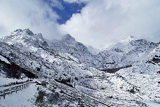
Serra da Estrela is the highest mountain range in Continental Portugal. Together with the Serra da Lousã it is the westernmost constituent range of the Sistema Central and also one of the highest in the system. It includes mainland Portugal's highest point at 1,993 metres above mean sea level. This point is not a distinctive mountain summit, but rather the highest point in a plateau, being known as Torre. Torre is an unusual summit in that it is accessible by a paved road. The peak has a topographic prominence of 1,204 m (3,950 ft) and its parent peak is Pico Almanzor, in Spain.

Altares Civil parish in Azores, Portugal

Altares is a freguesia in the municipality of Angra do Heroísmo on the Portuguese island of Terceira in the archipelago of the Azores. The population in 2011 was 901, in an area of 28.22 km2.

Castro Verde Municipality in Alentejo, Portugal

Castro Verde is a town and a municipality of the Alentejo region of Portugal. The population in 2011 was 7,276, in an area of 569.44 km2. Castro Verde is situated in the Baixo Alentejo subregion, within a territory known locally as the Campo Branco . The municipality can be recognized by the local municipal markers along its borders, that appear within its borders to denote its reference as A Window on the Plains; municipal markers appear as stylized house profiles, with an exaggerated window that allows the visitor to see through into the panorama.

Central Region, Portugal NUTS II Region in Central, Portugal

The Central Region or Central Portugal is one of the statistical regions of Portugal. The cities with major administrative status inside this region are Coimbra, Aveiro, Viseu, Caldas da Rainha, Leiria, Castelo Branco, Covilhã, Torres Vedras and Guarda. It is one of the seven Regions of Portugal. It is also one of the regions of Europe, as given by the European Union for statistical and geographical purposes. Its area totals 28,462 km2 (10,989 sq mi). As of 2011, its population totalled 2,327,026 inhabitants, with a population density of 82 inhabitants per square kilometre.

Seia Municipality in Centro, Portugal

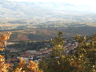
Seia is a municipality in Guarda District in Portugal. The population in 2011 was 24,702, in an area of 453.69 square kilometres (175.17 sq mi). Its urban population is about 7,000. Seia was elevated to city status on July 3, 1986.

Miranda do Corvo Municipality in Centro, Portugal

Miranda do Corvo is a town and a municipality in the Portuguese district of Coimbra, with an area of 126.38 square kilometres (48.80 sq mi) and 2011 population of 13,098 inhabitants.

Manteigas Municipality in Centro, Portugal

Manteigas is a town and a municipality in Portugal. The population in 2011 was 3,430, in an area of 121.98 square kilometres (47.10 sq mi).

Gouveia, Portugal Municipality in Centro, Portugal

Gouveia is a city and a municipality in the District of Guarda in Portugal. The municipality population in 2011 was 14,046, in an area of 300.61 square kilometres (116.07 sq mi). The town itself has a very small population, around 3.500.

Mangualde Municipality in Centro, Portugal

Mangualde is a municipality in the subregion of Dão-Lafões, central region of Portugal. The population in 2011 was 19,880, in an area of 219.26 km2.

Fornos de Algodres Municipality in Centro, Portugal

Fornos de Algodres is a municipality and a town in Portugal. The population in 2011 was 4,989, in an area of 131.45 km2. The municipality is located in Guarda District, Centro Region, Serra da Estrela Subregion. The present Mayor is Manuel Fonseca, elected by the Social Democratic Party. The municipal holiday is September 29.

Vodafone Ski Resort

Vodafone Ski Resort is a ski resort located in a mountain range named Serra da Estrela, in the municipality of Seia, parish (freguesia) of Loriga, Portugal.

Alcains Civil parish in Centro, Portugal

Alcains is a Portuguese civil parish in the municipality of Castelo Branco. The population in 2011 was 5,022, in an area of 36.94 km².

Guarda, Portugal Municipality in the centre of Portugal

Guarda is a city and a municipality in the District of Guarda and the capital of the Beiras e Serra da Estrela sub-region in central Portugal. The population in 2011 was 42,541, in an area of 712.10 square kilometres (274.94 sq mi) with 31,224 inhabitants in the city proper in 2006. Founded by King Sancho I in 1199, Guarda is the city located at the highest altitude in Portugal and one of the most important cities in the Portuguese region of Beira Alta. Serra da Estrela, the highest mountain range in continental Portugal, is partially located in the district. The city is served by national and international trains on the Beira Alta and Baixa railway lines. The present mayor is Carlos Chaves Monteiro, substituting for Álvaro Amaro. The municipal holiday is November 27.

Ferro is a town and civil parish in the municipality of Covilhã, Portugal. The population in 2011 was 1,700, in an area of 30.76 square kilometres (11.88 sq mi). Ferro is the Portuguese word for iron.

Santa Cruz (Coimbra) Civil parish in Centro, Portugal

Santa Cruz is a former civil parish in the municipality of Coimbra, Portugal. In 2013, the parish merged into the new parish Coimbra. In 2001, its population was 6866 inhabitants, in an area of 5.56 km² that parallels the north (right) margin of the Mondego River, extending to the village of Adémia in Trouxemil.

Monastery of Santa Maria de Maceira Dão Church in Centro, Portugal

The Monastery of Santa Maria de Maceira Dão is a monastery in the civil parish of Fornos de Maceira Dão, in the municipality of Mangualde in the Portuguese central subregion of Dão-Lafões, classifies as National Monuments.

Castle of Avô

The Castle of Avô is a medieval castle located in the civil parish of Avô, municipality of Oliveira do Hospital, in the Portuguese district of Coimbra.

Beiras e Serra da Estrela Intermunicipal community in Centro, Portugal

The Comunidade Intermunicipal das Beiras e Serra da Estrela is an administrative division in eastern Portugal. It was created in 2013. Since January 2015, Beiras e Serra da Estrela is also a NUTS3 subregion of Centro Region, that covers the same area as the intermunicipal community. The seat of the intermunicipal community is Guarda. Beiras e Serra da Estrela comprises parts of the former districts of Guarda and Castelo Branco. The population in 2011 was 236,023, in an area of 6,304.95 square kilometres (2,434.35 sq mi).

Girabolhos is a civil parish in the municipality of Seia, Portugal. The population in 2011 was 317, in an area of 17.88 km².

References

  1. Instituto Nacional de Estatística
  2. "Áreas das freguesias, concelhos, distritos e país". Archived from the original on 2018-11-05. Retrieved 2018-11-05.
  3. 1 2 Junta Freguesia, ed. (2011). "Conhece em Loriga...Geografia em Loriga" (in Portuguese). Loriga (Seia), Portugal: Junta de Freguesia de Loriga. Archived from the original on 13 March 2012. Retrieved 17 June 2011.