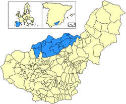
Los Montes

Last updated
Comarca de Los Montes
LocationLos Montes.png
Coordinates: 37°28′56″N3°25′50″W / 37.48222°N 3.43056°W / 37.48222; -3.43056 Coordinates: 37°28′56″N3°25′50″W / 37.48222°N 3.43056°W / 37.48222; -3.43056
Country Spain
Autonomous community Andalusia
Province Granada
Area
  Total1,381 km2 (533 sq mi)
Population
 (2012)
  Total26,420
  Density19/km2 (50/sq mi)

Los Montes is a Spanish region located in the northern part of the province of Granada, community of Andalusia, Spain. This territory limits with the Granada's counties of Baza in the northwest, Guadix in the east and south, Vega de Granada in the south, and Loja in the west, as well as with the Jaen counties of Sierra Sur de Jaén in the northwest, Sierra Mágina in the north, and Sierra de Cazorla in the northeast.

In the eastern part of the region, the zone or sub-county of Montes Orientales is located. The sub-county of Montes Orientales is located in the northeast part, occupying around of 1,400 km², which extends from Fardes and Guadiana Menor rivers to Frailes river. Its main mountainous system, located in the east, is Sierra Arana, a double limestone anticlinal alignment of 30 km of length, with an average altitude of 1,200 m.a.s.l (metres above sea level), being its highest level the Cerro or Peñón de la Cruz, with 2,030 m.a.s.l.

It is subdivided into the sub-county of Iznalloz (district capital), in the transition zone with the western part, and the sub-county of Pedro Martínez, more to the eastward. It predominates a landscape dominated by the hills with traditional agriculture, with herbaceous mainly, together with the mountains and dome hills with natural and repopulated vegetation, although also cultivated (mostly towards the west, where a wide range of woody crops appear).

There are also some irrigated plains (Cubillas and Guadahortuna rivers). All the population centres of the region are located above from 630 m.a.s.l and 14 of them exceed 1,000. The average altitude is 942.2 m; being Villanueva de las Torres the one which has the lowest altitude (633 m) and Torre-Cardela (1,217 m) the one which has the highest one. In line with its relief and proximity to the sea, it counts with a humid continental climate, which presents elements of mediterranean influence similar to areas as the Levantine, together with others more typical from the central plateau. There are long and cold winters and, at the other end, equally long and hot summers. The rainfall is scarce (less than 600 I) of unequal distribution, descending from west to east: 700 mm/year in Iznalloz, 300 mm/year in Pedro Martínez. The average annual temperature is 15 °C, oscillating between 6 and 7 °C in January and the almost 26 °C of average in July.

It contains the following municipalities: [1]

Related Research Articles

Province of Granada Province of Spain

Granada is a province of southern Spain, in the eastern part of the autonomous community of Andalusia. It is bordered by the provinces of Albacete, Murcia, Almería, Jaén, Córdoba, Málaga, and the Mediterranean Sea. Its capital city is also called Granada.

Boyacá Department Department of Colombia

Boyacá is one of the thirty-two departments of Colombia, and the remnant of Boyacá State, one of the original nine states of the "United States of Colombia".

Magdalena Department Department of Colombia

Magdalena is a department of Colombia with more than 1.3 million people, located to the north of the country by the Caribbean Sea. The capital of the Magdalena Department is Santa Marta and was named after the Magdalena River. It inherited the name of one of the original nine states of the United States of Colombia that its current territory integrated.

Comarcas of Spain

In Spain traditionally and historically, some autonomous communities are also divided into comarcas.

Sierra Morena

The Sierra Morena is one of the main systems of mountain ranges in Spain. It stretches for 450 kilometres from east to west across the south of the Iberian Peninsula, forming the southern border of the Meseta Central plateau and providing the watershed between the valleys of the Guadiana to the north and the west, and the Guadalquivir to the south.

Guadix Municipality in Andalusia, Spain

Guadix is a city and municipality in southern Spain, in the province of Granada, autonomous community of Andalusia.

Iznalloz Municipality in Andalusia, Spain

Iznalloz is a small town about 35 km north of Granada, Spain. The town is the main center of a region known as Los Montes Orientales, which comprises about 17 towns and villages spread over the north of the province of Granada. Encompassed within this area is the Sierra Arana mountain range.

Montefrío Montefrío

Montefrio is a municipality in the province of Granada. The ruins of a Moorish castle sit near the highest point. Being built midway between the Sierra de Priego and Sierra Parapanda, and commanding the open valley between these ranges, it became one of the chief frontier fortresses of the Moors in the 15th century.

Olivares is a city located in the Province of Seville, Spain. According to the 2016 census (INE), the city has a population of 9480 inhabitants. It is located in the Aljarafe, the comarca downstream of the Guadalquivir and west of Seville. It borders Albaida to the west, Gerena to the north, Salteras to the east, and Sanlúcar la Mayor and Villanueva del Ariscal to the south. After the establishment of the House of Olivares, it grew in size and influence, becoming an important urban center in the Aljarafe.

Valdepeñas de Jaén city in Andalusia, Spain

Valdepeñas de Jaén is a city located in the province of Jaén, Spain. According to the 2005 census (INE), the city had a population of 4,315.

Las Gabias city in Andalusia, Spain

Las Gabias is a Spanish city and municipality located in the central southern part of the Vega of Granada, in the province of Granada, in the autonomous community of Andalusia, approximately 8 km from the provincial capital of Granada. It borders the municipalities of Vegas del Genil, Cúllar Vega, Churriana de la Vega, Alhendín, La Malahá, Chimeneas and Santa Fe. Las Gabias includes the localities of “Gabia Grande”, the municipal capital, and “Gabia Chica” that were a unified with the region in 1973, in addition to the annexation of Híjar, Los Llanos, Pedro Verde and San Javier. The name may have originated from Hisn Caviar, which means “military tower”, in allusion to the one that still exists in Gabia Grande. It is one of the most populous municipalities in Spain as well as one of the youngest, with the median age of inhabitants being only 34.3 years of age. In 2016, the population of Las Gabias surpassed 20,000, making it the fourth most populous municipality in the Granada Metropolitan Area, surpassed only by Granada, Armilla and Maracena.

Píñar municipality in Granada, Spain

Píñar is a municipality located in the province of Granada, Spain. It is located at 46 km from Granada, and 11 km from Iznalloz, capital of the Comarca of Los Montes Orientales.

Llerena, Badajoz Place in Extremadura, Spain

Llerena is a municipality located in the province of Badajoz, Extremadura, Spain. According to the 2007 census (INE), the municipality has a population of 5,995 inhabitants. Llerena, a town that declared itself a Historical Artistic gathering on December 29, 1966, is located in southwestern Spain. The head of the judicial and economic center of the Region of the country of the same name, it is equidistant from 20 municipalities, and sits at the confluence of the District 432 and 413 National Roads.

Subbaetic System

The Subbaetic or Sub-Baetic System is one of the three systems of mountain ranges of the Baetic System in the southern Iberian Peninsula. Highest point 2,027 m (6,650 ft) high Peña de la Cruz in Sierra Arana. Its northern limit includes the valley of the Guadalquivir in its western part.

Dehesa del Carrizal is a Vino de Pago from Spain. This is the highest category on the quality scale of Spanish wines and means that in addition to having a proven track record of consistent quality, the wines have to be both produced from estate-grown grapes and also have to be processed and aged in a winery (bodega) located on the estate.

Sierras de Cazorla, Segura y Las Villas Natural Park

Sierras de Cazorla, Segura y Las Villas Natural Park is a natural park in the eastern and northeastern part of the province of Jaén, Spain, established in 1986. With an area of 2,099.2 square kilometres (810.5 sq mi), it is the largest protected area in Spain and the second largest in Europe. It was declared a biosphere reserve by UNESCO in 1983 and also a Special Protection Area for migratory birds in 1988.

Sierra Arana

The Sierra Arana or Sierra de Arana, also known as Sierra Harana, is a mountain range in the center of the province of Granada, southern Spain. Its highest peak is the Peña de la Cruz, at 2,027 m (6,650 ft).

Siles, Spain Place in Andalusia, Spain

Siles is a Spanish town and municipality in the province of Jaén, in the autonomous community of Andalusia, located in the region of Sierra de Segura, bordering the province of Albacete. It has a population of 2,451 inhabitants according to the last available census (INE2011). Much of the municipality is located within the Natural Park of Sierra de Cazorla, Segura and Las Villas. Because of its location it is a mostly forest town near the river, farmland focusing mainly olive grove, in a strip of southwest-northeast direction including the vicinity of the town center and the municipal enclave that owns the town northwest of the region.

Montes de Toledo

The Montes de Toledo are one of the main systems of mountain ranges in the Iberian Peninsula. They divide the drainage basin of the Tagus from the basin of the Guadiana. The highest peak is 1,603 m (5,259 ft) high La Villuerca.

Guadahortuna Municipality in Andalusia, Spain

Guadahortuna is a municipality of the province of Granada, in the autonomous community of Andalusia, Spain.

References

  1. "Los Montes". www.geopostcodes.com. Retrieved 2017-12-26.