Vega de Granada | |
---|---|
![]() Location of Vega de Granada in the province of Granada. | |
Country | ![]() |
Autonomous community | Andalusia |
Province | Granada |
Capital | Granada |
Area | |
• Total | 1,362.22 km2 (525.96 sq mi) |
Population (2024) [notes 1] | |
• Total | 565,818 |
• Density | 420/km2 (1,100/sq mi) |
Time zone | UTC+1 (CET) |
• Summer (DST) | UTC+2 (CEST) |
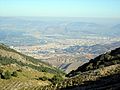
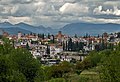
The Vega de Granada is a comarca (county, but with no administrative role) in the province of Granada, in Andalusia, Spain. The name refers to the basin near the city of Granada.
This comarca was established in 2003 by the Government of Andalusia. [1] [2]
The Vega de Granada comarca is located in the central part of the province, at the eastern area of the depression of Granada and the neighbouring mountain ranges of Sierra Nevada, Sierra de Huétor and Sierra de la Alfaguara. It shares borders with the comarcas of Los Montes to the north, Guadix to the east, Alpujarra Granadina to the southeast, Valle de Lecrín to the south, Alhama to the southwest and Loja to the west.
The comarca contains the following 41 municipalities:
Arms | Municipality | Area (km2) | Population (2024) [3] [notes 2] | Density (/km2) |
---|---|---|---|---|
![]() | Albolote | 78.6 | 19,587 | 249.2 |
![]() | Alfacar | 16.7 | 5,784 | 346.3 |
![]() | Alhendín | 50.8 | 10,399 | 204.7 |
![]() | Armilla | 4.3 | 25,405 | 5,908.1 |
![]() | Atarfe | 47.3 | 20,455 | 432.5 |
![]() | Beas de Granada | 23.2 | 1,009 | 43.5 |
![]() | Cájar | 1.7 | 5,492 | 3,230.6 |
![]() | Calicasas | 11.2 | 658 | 58.8 |
![]() | Cenes de la Vega | 6.5 | 8,296 | 1,276.3 |
![]() | Chauchina | 21.2 | 5,781 | 272.7 |
![]() | Churriana de la Vega | 6.6 | 16,693 | 2,529.2 |
![]() | Cijuela | 17.9 | 3,714 | 207.5 |
![]() | Cogollos Vega | 49.8 | 2,084 | 41.8 |
![]() | Cúllar Vega | 4.4 | 7,809 | 1,774.8 |
![]() | Dílar | 79.3 | 2,319 | 29.2 |
![]() | Dúdar | 8.4 | 373 | 44.4 |
![]() | Fuente Vaqueros | 16.0 | 4,625 | 289.1 |
![]() | Las Gabias | 39.0 | 23,318 | 597.9 |
![]() | Gójar | 12.0 | 6,340 | 528.3 |
![]() | Granada | 88.0 | 232,717 | 2,644.5 |
![]() | Güéjar Sierra | 239.0 | 2,926 | 12.2 |
![]() | Güevéjar | 9.8 | 2,660 | 271.4 |
![]() | Huétor Santillán | 93.3 | 1,938 | 20.8 |
![]() | Huétor Vega | 4.2 | 12,294 | 2,899.5 |
![]() | Jun | 3.7 | 4,145 | 1,120.3 |
![]() | Láchar | 13.1 | 3,826 | 292.1 |
![]() | Maracena | 4.9 | 22,310 | 4,553.1 |
![]() | Monachil | 88.9 | 8,608 | 96.8 |
![]() | Nívar | 11.2 | 1,069 | 95.4 |
![]() | Ogíjares | 6.9 | 15,063 | 2,183.0 |
![]() | Peligros | 10.1 | 11,674 | 1,155.8 |
![]() | Pinos Genil | 14.0 | 1,638 | 117.0 |
![]() | Pinos Puente | 92.9 | 9.708 | 104.5 |
![]() | Pulianas | 6.3 | 5,628 | 893.3 |
![]() | Quéntar | 66.5 | 943 | 14.2 |
![]() | Santa Fe | 38.2 | 15,269 | 399.7 |
![]() | Valderrubio | 5.5 | 2,077 | 377.6 |
![]() | Vegas del Genil | 14.2 | 12,325 | 868.0 |
![]() | Villa de Otura | 24.3 | 7,606 | 313.0 |
![]() | Víznar | 13.0 | 997 | 76.7 |
![]() | La Zubia | 20.1 | 20,056 | 997.8 |
Total | 1363.0 | 565,818 | 415.1 |
37°11′15″N3°36′39″W / 37.18750°N 3.61083°W