Albolote

Last updated
Albolote
City
Bandera de Albolote (Granada).svg
Escudo de Albolote (Granada).svg
LocationAlbolote.png
Location of Albolote
Coordinates: 37°13′50″N3°39′25″W / 37.23056°N 3.65694°W / 37.23056; -3.65694 Coordinates: 37°13′50″N3°39′25″W / 37.23056°N 3.65694°W / 37.23056; -3.65694
Country Spain
Province Granada
Comarca Vega de Granada
Municipality Albolote
Area
  Total79 km2 (31 sq mi)
Elevation
655 m (2,149 ft)
Population
 (2018) [1]
  Total18,746
  Density240/km2 (610/sq mi)
Time zone UTC+1 (CET)
  Summer (DST) UTC+2 (CEST)
Website http://www.albolote.org/portal/

Albolote is a city located in the province of Granada, Spain. It is one of the thirty-four entities which together form Granada's Metropolitan Area. It is formed by several populations: El Aire, El Chaparral, and Parque del Cubillas y Pretel. There are also several residential areas throughout the legal borders of the municipality. Inside those limits you can also find Granada's Penitential Center (Centro Penitencial de Granada, in Spanish). According to Spain's Instituto Nacional de Estadística, the city had a total population of 15,563 in 2005.

Contents

On 19 April 1956, Albolote and the neighboring town of Atarfe were struck by a 5.0 earthquake, Spain's most destructive of the 20th century. About a dozen people died from the earthquake and subsequent landslide, and many buildings were ruined.

The Granada metro network, scheduled to open in 2014, will provide the town with a light metro link to central Granada.

History

Albolote was born as a town with the arrival of the Nasrid dynasty to the Emirate of Granada. The term comes from the Arabic term 'Qaryat al-Bollut', meaning 'Oak town' It was planned to be a place of rest for the troops guarding the Royal Path of Jaén. Near Albolote took place the Battle of La Higueruela on July first 1431, where king's Juan II of Castille's troops defeated the Muslim armies. This battle was illustrated at the Monastery El Escorial.

In the 17th century it changed to be an estate of Don Antonio Álvarez de Bohórquez, the first marquis de los Trujillos. In the year 1803 the king, Carlos IV gave the title of Duque de Gor to Don Nicolás Mauricio Álvarez de Bohórquez.

Geography

There are four rivers which flow through Albolote: Juncaril, Colomera, Cubillas, and Magon. It is also worth mentioning the Cubillas reservoir, dedicated both to leisure and water reserve.

Climate

Albolote enjoys a mediterranean climate: fresh winters and hot summers. There's a great thermic oscillation varying up to 20 °C in a single day. Most of the rain falls during winter, meaning it scarcely rains throughout the summer.

Climatic parametersin Albolote
MonthJanFebMarAprilMayJunJulAugSepOctNovDecAnnual
Maximum temperature (°C)13.015.318.620.124.630.034.433.929.422.717.213.522.7
Average temperature (°C)6.78.511.012.816.821.424.824.520.915.510.77.615.1
Average minimum temperature

(°C)

0.31.83.45.69.012.915.215.012.48.24.21.87.5
Total precipitations (mm)4138303828174316424853357
Font: Metereological State Agency of Spain

Demography

According to the Instituto Nacional de Estadística de España, in the year 2014 Albolote had 18,306 inhabitants.

Politics

These are the results for the last elections in Albolote:

Town Hall Albolote 2015
Politic GroupVotos%ValidCharges obtained
Partido Popular (PP)2.62329,60%6
Partido Socialista Obrero Español (PSOE)2.336326,67%5
Izquierda Unida- Ganemos Albolote para la Gente (PG)1.53017,27%3
Ciudadanos- Partido de la ciudadanía (C's)1.16013,09%2
Agrupación Electoral Ganar Albolote (GA)7098%1

Communications

In Albolote a lot of important roads converge: autovías A-44 that joins Jaen with Granada and its cost-with the A-92, between Almeria and Sevilla. It also stands out the future Segunda circunvalación de Granada (GR-30), that is currently under construction. This road will join Albolote and Alhendin without the need to cross through the center of Granada, with the relieve that this will suppose to the vehicles that come from Ciudad Real and Jaén to the costa mediterránea in Granada.

The principal roads are:

IdentificatorDenominationItinerary
A-44Autovía de Sierra NevadaBailén – Motril
GR-30Segunda circunvalación de GranadaAlbolote – Alhendín
A-92Autovía A-92Sevilla – Almería
N-323aCarretera de Sierra NevadaBailén – Motril
A-4076'Carretera de Colomera'Parque del Cubillas -Colomera
GR-3417De Maracena a Santa Fe por

Albolote y Atarfe5

Maracena – Santa Fe
GR-3419'De A-44 a GR-3424'5El Chaparral -Güevéjar
GR-3423De A-44 a Iznalloz5Deifontes – Iznalloz

Bus

Albolote has a bus service run by Granada's consortium:

Line 122 (Granada-Maracena-Albolote-Atarfe)

Line 123 (Granada-Albolote por Carretera de Jaén)

Line 117 (Granada-Pantano de Cubillas)

METRO:

Since September 2017, Albolote is connected to Granada by the metro.

Public services

Healthcare

Albolote has a basic zone of healthcare, inside the sanitary district of Granada. The town has a healthcare center in the street Alfonso XIII Nº7, and a medical consultory in the town of Chaparral.

Education

The town has 13 education centers where there is education for people of all ages:

Generic Denomination'Name''Nature''Address'
Education center for adultsS.E.P. "Albolut"PublicDoctor Burgos Canals, 6
Education center for adultsC.E.P. "Concepción Arenal"PublicCtra. de Colomera km. 16,5
Private educational instituteColegio "Ave María"PrivateJacobo Camarero, 3
Private pre-school education centerE.I. "Anaki"PrivateBaza, parcela 345. P.I. Juncaril
Private pre-school education centerE.I. "Galopín"PrivateFray Bartolomé de las Casas, 4
Private pre-school education centerE.I. "Loma Verde"PrivateAv. de las Acacias, s/n. Urbanización Loma Verde
Private pre-school education centerE.I. "Nenes"PrivateDoctor Laureano Vázquez, 4, locales 7 y 8
Primary schoolC.E.I.P. "Abadía"PublicAbadía, 36
Primary schoolC.E.I.P. "San Isidro Labrador"PublicAv. de las Acacias, s/n. El Chaparral
Primary schoolC.E.I.P. "Tínar"PublicTínar, 46
Pre-schoolE.I. "El Parque"PublicDoctor Burgos Canals, s/n
Pre-schoolE.I. "Francisco Lucilo de Carvajal"PublicDoctor Burgos Canals, 8
Secondary Education instituteI.E.S. "Aricel"PublicAricel, s/n

Culture

The popular celebrations are held during the first weekend of August beginning in Thursday. These celebrations are in honor of the saint of the town, the Holly Christ of Health.

Related Research Articles

<span class="mw-page-title-main">Jaén, Spain</span> Municipality in Andalusia, Spain

Jaén is the urban capital city of the province of Jaén, in the autonomous community of Andalusia, Spain.

<span class="mw-page-title-main">Barva</span> District in Barva canton, Heredia province, Costa Rica

Barva is a district of the Barva canton, in the Heredia province of Costa Rica. The city is known for having a nice mix of rural and metropolitan landscape.

<span class="mw-page-title-main">Huancayo</span> Place in Junin, Peru

Huancayo is the capital of Junín Region, in the central highlands of Peru.

Rubén Torrecilla González is a Spanish retired footballer who played as a midfielder, and is a current manager.

<span class="mw-page-title-main">El Hatillo Municipality</span> Municipality in Miranda, Venezuela

El Hatillo Municipality is an administrative division of the State of Miranda, Venezuela; along with Baruta, Chacao, Libertador and Sucre, it is one of the five municipalities of Caracas, the capital of Venezuela. It is located in the southeastern area of Caracas, and in the northwestern part of the State of Miranda.

<span class="mw-page-title-main">Segura de la Sierra</span> Municipality in Andalusia, Spain

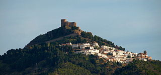
Segura de la Sierra is a small village in the province of Jaén, (Spain), that belongs to the region of Sierra de Segura in eastern Andalusia.

<span class="mw-page-title-main">Atarfe</span> Municipality in Andalusia, Spain

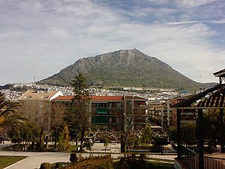
Atarfe is a Spanish city in the north central part of the Vega of Granada in the province of Granada, Andalusia. It borders the municipalities of Moclín, Colomera, Albolote, Maracena, Granada, Santa Fe, and Pinos Puente. By this village run the Rivers Cubillas and Colomera. Its districts include Caparacena, Sierra Elvira, Hurpe and Cubillas.

<span class="mw-page-title-main">Alcalá la Real</span> City in Jaén, Spain

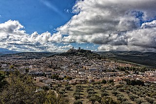
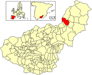
Alcalá la Real is a city in the province of Jaén, Spain. According to the 2006 census (INE), the city has a population of 22,129.

Las Gabias is a Spanish city and municipality located in the central southern part of the Vega of Granada, in the province of Granada, in the autonomous community of Andalusia, approximately 8 km from the provincial capital of Granada. It borders the municipalities of Vegas del Genil, Cúllar Vega, Churriana de la Vega, Alhendín, La Malahá, Chimeneas and Santa Fe. Las Gabias includes the localities of "Gabia Grande", the municipal capital, and "Gabia Chica" that were a unified with the region in 1973, in addition to the annexation of Híjar, Los Llanos, Pedro Verde and San Javier. The name may have originated from Hisn Caviar, which means "military tower", in allusion to the one that still exists in Gabia Grande. It is one of the most populous municipalities in Spain as well as one of the youngest, with the median age of inhabitants being only 34.3 years of age. In 2016, the population of Las Gabias surpassed 20,000, making it the fourth most populous municipality in the Granada Metropolitan Area, surpassed only by Granada, Armilla and Maracena.

<span class="mw-page-title-main">Maracena</span> City in Granada, Spain

Maracena is a municipality located in the province of Granada, Spain. According to the 2005 census (INE), the city has a population of 18819 inhabitants. It is located in the central part of the Vega de Granada, being one of the fifty-two entities that make up the metropolitan area of Granada.It borders the municipalities of Peligros, Pulianas, Granada, Atarfe and Albolote. Other nearby towns are Pulianillas and Monteluz.

<span class="mw-page-title-main">Zapotlán el Grande</span> Place in Jalisco, Mexico

Zapotlán el Grande is a municipality in the Mexican state of Jalisco.

<span class="mw-page-title-main">Costa Granadina</span> Comarca in Andalusia, Spain

Costa Granadina is a comarca in southern Spain, corresponding to the Mediterranean coastline of the province of Granada. It is also but less frequently called the Costa Tropical or Costa de Granada. It is crossed by the N-340 coastal highway that runs southwest–northeast along Spain's Mediterranean coast, to the border with France. Within the last 4 years the A7 motorway has been extended along the coast from Nerja in the Málaga province to Motril where it links the A7 motorway to the A44 motorway which heads north from Motril to the city of Granada.

Cubillas Reservoir is a reservoir in the province of Granada, Andalusia, Spain.

<span class="mw-page-title-main">Instituto Nacional de Colonización</span>

The Instituto Nacional de Colonización y Desarrollo Rural, English: National Institute of Rural Development and Colonization, was the administrative entity that was established by the Spanish State in October 1939, shortly after the end of the Spanish Civil War, in order to repopulate certain areas of Spain. This entity depended from the Ministry of Agriculture and it sought to alleviate the effects of the devastation caused by the three years of civil war.

<span class="mw-page-title-main">Granada Metro</span>

The Granada Metro is a single light rail line in the city of Granada, Spain and its metropolitan area. It crosses Granada and covers the towns of Albolote, Maracena and Armilla, with underground sections in central Granada and overground sections elsewhere. The line opened on 21 September 2017, and serves 26 stations, of which 3 stations in central Granada are underground.

Juan Manuel "Juanma" Ortiz Jiménez is a Spanish footballer. He currently plays for Faroese club Knattspyrnudeild UMFG as a forward.

Abu al-Hassan Ali al-Mandari al-Garnati, also known as Almandari, Almandali, Al-Mandri I and Sidi al-Mandri, was the re-founder of the city of Tetouan in Morocco. He was born in Granada, Spain c.1440 and died in Tétouan on an unknown date in between 1515 and 1541.

Sabanilla is a district of the Alajuela canton, in the Alajuela province of Costa Rica.

The 1956 Atarfe-Albolote earthquake was a magnitude 5.0 Mw earthquake that ocurred at 18:38 CEST on April 19, 1956. The earthquake affected a wide area, and especially the area between Sierra Elvira and Granada. According to the press at the time, the towns of Atarfe and Albolote were ruined and Santa Fe, Maracena and some neighborhoods in the capital of Granada were badly affected. The earthquake registered an epicentral intensity of VIII, a magnitude of 5.0 and a hypocentral depth of 6.3 km. Numerous aftershocks occurred, of which the most important were recorded between April 19 and May 8. Twelve people died and 60 were left injured. Among other effects, the earthquake caused rockfalls in Sierra Elvira and landslides along the Beiro River.

References

  1. Municipal Register of Spain 2018. National Statistics Institute.