Louden Coal Camp | |
---|---|
Unincorporated community | |
Coordinates: 36°45′2″N84°1′44″W / 36.75056°N 84.02889°W Coordinates: 36°45′2″N84°1′44″W / 36.75056°N 84.02889°W | |
Country | United States |
State | Kentucky |
County | Whitley |
Elevation | 948 ft (289 m) |
Time zone | Central (CST) (UTC-6) |
• Summer (DST) | CST (UTC-5) |
GNIS feature ID | 2710201 [1] |
Louden Coal Camp was an unincorporated community and coal town located in Whitley County, Kentucky, United States.
In law, an unincorporated area is a region of land that is not governed by a local municipal corporation; similarly an unincorporated community is a settlement that is not governed by its own local municipal corporation, but rather is administered as part of larger administrative divisions, such as a township, parish, borough, county, city, canton, state, province or country. Occasionally, municipalities dissolve or disincorporate, which may happen if they become fiscally insolvent, and services become the responsibility of a higher administration. Widespread unincorporated communities and areas are a distinguishing feature of the United States and Canada. In most other countries of the world, there are either no unincorporated areas at all, or these are very rare; typically remote, outlying, sparsely populated or uninhabited areas.
A coal town, also known as a coal camp or patch is typically situated in a remote place and provides residences for a population of miners to reside near a coal mine. A coal town is a type of company town or mining community established by the employer, a mining company, which imports workers to work the mineral find. The 'town founding' process is not limited to coal mining, nor mining, but is generally found where mineral wealth is located in a remote or undeveloped area, which is then opened for exploitation, normally first by having some transportation infrastructure brought into being first. Often, such minerals were the result of logging operations by pushing into a wilderness forest, which clear-cutting operations then allowed geologists and cartographers, to chart and plot the lands, allowing efficient discovery of natural resources and their exploitation.
Whitley County is a county in the U.S. state of Kentucky. As of the 2010 census, the population was 35,637. The county seat is at Williamsburg, though the largest city is Corbin, and the county's District Court sits in both cities.
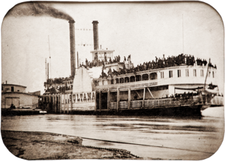
Sultana was a Mississippi River side-wheel steamboat. On April 27, 1865, the boat exploded in the worst maritime disaster in United States history. She was designed with a capacity of only 376 passengers, but she was carrying 2,137 when three of the boat's four boilers exploded and she burned to the waterline and sank near Memphis, Tennessee, killing 1,168 passengers. This disaster was overshadowed in the press by other events surrounding the end of the American Civil War, most particularly the killing on the previous day of President Lincoln's assassin John Wilkes Booth.
Highsplint is a former coal town with an extinct post office in Harlan County, Kentucky, United States. It was named for the High Splint and Seagraves Coal Companies which operated a mine in the town at that time. Highsplint's first post office was established on February 7, 1918, with John D. Casey as postmaster, remaining in operation until 1974.
Robert Louden, also known by the alias Charlie Dale, was a Confederate saboteur and mail carrier during the American Civil War. He was said to be the primary messenger between General Sterling Price and Confederate regulars and bushwhackers.
Stone is an unincorporated community and coal town in Pike County, Kentucky, United States. It was established in 1912. Stone was a mining community named for Galen Stone, head of the Pond Creek Coal Company which was based in Stone. In 1922 the Pond Creek Coal Company was sold to Fordson Coal Company, which was a subsidiary of Ford Motor Company. In 1936 Fordson sold the mine at Stone to Eastern Coal Company.
Barthell is a former coal town in McCreary County, Kentucky, United States. It was established in 1902 and was the first of 18 mining camps to be built by the Stearns Coal and Lumber Company. It now serves as an open-air history museum, which is open from April through Thanksgiving.
Arjay Coal Camp was an unincorporated community located in Bell County, Kentucky, United States.
Glendon Coal Camp was an unincorporated community located in Bell County, Kentucky, United States.
Red Ash Coal Camp was an unincorporated community and coal town located in Whitley County, Kentucky, United States.
Kettle Island Coal Camp was an unincorporated community located in Bell County, Kentucky, United States.
New Alma Coal Camp was an unincorporated community and coal town located in Pike County, Kentucky, United States.
Henry Clay is an unincorporated community and coal town located in Pike County, Kentucky, United States. It was also known as the Henry Clay Coal Camp.
Three Point Coal Camp was an unincorporated community in Harlan County, Kentucky, United States. The Three Point Post Office is closed.
Closplint is an unincorporated community in Harlan County, Kentucky, United States. The settlement was named Cloversplint after the seam of coal and the mining company that built it as a coal town in 1926 , and operated there between 1928 and 1946 . When the United States Postal Service established a post office, the name was shortened to Closplint.
Darby Coal Mining Camp was an unincorporated community and coal town in Harlan County, Kentucky, United States.
Gano Coal Camp was an unincorporated community and coal town in Harlan County, Kentucky, United States.
Wheeler Coal Camp was an unincorporated community and coal town in Harlan County, Kentucky, United States.
Black Star Coal Camp is an unincorporated community and coal town in Harlan County, Kentucky, United States.
Slick Lizard Coal Camp was an unincorporated community and coal town in Knox County, Kentucky, United States.
Powers Coal Camp is an unincorporated community and coal town in Knox County, Kentucky, United States.
The London, Kentucky micropolitan area is made up of three counties in the Eastern Coalfield region of Kentucky. Before 2013, the area was officially known as the Corbin-London, KY Combined Statistical Area, and consisted of the Corbin Micropolitan Statistical Area and the London Micropolitan Statistical Area. The Corbin micropolitan area consisted of Whitley County, and the London micropolitan area consisted of Laurel County.
This Whitley County, Kentucky state location article is a stub. You can help Wikipedia by expanding it. |