
Campbell County is a county located in the U.S. state of Tennessee. As of the 2010 census, the population was 40,716. Its county seat is Jacksboro.

Daviess County ( "Davis"), is a county in the U.S. state of Kentucky. As of the 2010 census, the population was 96,656. Its county seat is Owensboro. The county was formed from part of Ohio County on January 14, 1815.

Breathitt County is a county located in the eastern Appalachian portion of the U.S. state of Kentucky. As of the 2010 census, the population was 13,878. Its county seat is Jackson, Kentucky. The county was formed in 1839 and was named for John Breathitt, who was Governor of Kentucky from 1832 to 1834. Breathitt County was a prohibition or dry county, until a public vote in July 2016 that allowed alcohol sales.

Jellico is a city in Campbell County, Tennessee, United States, on the state border with Kentucky, 58 miles (93 km) by road north of Knoxville. The population was 2,355 at the 2010 census.
The Church of God, Mountain Assembly (CGMA) is a holiness Pentecostal Christian body formed in 1907, with roots in the late 19th-century American holiness movement and early 20th-century Pentecostal revival. The denomination maintains headquarters in Jellico, Tennessee and is a member of the Pentecostal/Charismatic Churches of North America.
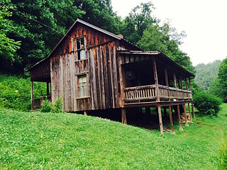
Butcher Hollow is a coal-mining community located in Johnson County, Kentucky, United States. It is the birthplace of country music legend Loretta Lynn, who paid tribute to the community in the song "Coal Miner's Daughter", which begins with the lyrics
Well, I was born'd a coal miner's daughter
In a cabin on a hill in Butcher Holler
East Kentucky Broadcasting is a network of radio stations serving the Eastern Kentucky area.

Indian Mountain State Park is a state park in Campbell County, Tennessee, in the southeastern United States. Established in 1971, the park consists of 213 acres (0.86 km2) situated at the base of Indian Mountain, a 1,949-foot (594 m) summit that overlooks the Elk Valley in the Cumberland Mountains. The park is located immediately west of the city of Jellico, and the history and development of the two are intertwined to a great extent.

Pine Mountain is a ridge in the Appalachian Mountains running through Kentucky, Virginia and Tennessee. It extends about 125 miles from near Jellico, Tennessee, to a location near Elkhorn City, Kentucky. Birch Knob, the highest point, is 3,273 feet above sea level and is located on the Kentucky-Virginia border. It has been a barrier to transportation as the Cumberland River at Pineville, Kentucky is one of only two streams passing through the entire ridge. The other is Hickory Creek near Jellico, TN.

Clairfield is an unincorporated community in Claiborne County, Tennessee, United States. It is located in the upper Clearfork Valley in the Cumberland Mountains of northeastern Tennessee. It is the site of a post office, assigned ZIP code 37715. The population of the Zip Code Tabulation Area corresponding to Clairfield's ZIP code was 1,002 as of the 2000 Census.

Stone is an unincorporated community and coal town in Pike County, Kentucky, United States. It was established in 1912. Stone was a mining community named for Galen Stone, head of the Pond Creek Coal Company which was based in Stone. In 1922 the Pond Creek Coal Company was sold to Fordson Coal Company, which was a subsidiary of Ford Motor Company. In 1936 Fordson sold the mine at Stone to Eastern Coal Company.
WKLB 104.5FM and 1290AM is a radio station broadcasting a Rock & Roll, Country and Contemporary Christian format. It is icensed to Manchester, Kentucky, United States. The station is owned by Robert Rodgers and Curt Davis, through licensee Sonshine Broadcasting Company, Ltd., and features programming from Fox News Radio and the Kentucky News Network.

Tanner's Creek Generating Station was a major, 1000-MWe coal-fired electrical power plant in Indiana. Located on the north bank of Ohio River, it was one of the two coal-fired power stations within 3 miles (5 km) of Lawrenceburg, Indiana, near the tripoint of Indiana, Ohio, and Kentucky. The former plant is situated directly across the Ohio river from Petersburg, Boone County, Kentucky. Tanner's Creek was one of the two Indiana coal power plants owned by Indiana Michigan Power, a subsidiary of American Electric Power.

The Coal Creek War was an early 1890s armed labor uprising in the southeastern United States that took place primarily in Anderson County, Tennessee. This labor conflict ignited during 1891 when coal mine owners in the Coal Creek watershed began to remove and replace their company-employed, private coal miners then on the payroll with convict laborers leased out by the Tennessee state prison system.
Kayjay is an unincorporated community located in Knox County, Kentucky, United States. Its name comes from the initials of the Kentucky-Jellico Coal Company.

The London, Kentucky micropolitan area is made up of three counties in the Eastern Coalfield region of Kentucky. Before 2013, the area was officially known as the Corbin-London, KY Combined Statistical Area, and consisted of the Corbin Micropolitan Statistical Area and the London Micropolitan Statistical Area. The Corbin micropolitan area consisted of Whitley County, and the London micropolitan area consisted of Laurel County.
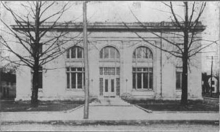
The U.S. Post Office and Mine Rescue Station in Jellico, Tennessee, is a historic building built in 1915 to house two U.S. federal government functions. It was listed on the National Register of Historic Places in 1984.
State Route 90 is a 13.5-mile-long (21.7 km) state highway in Campbell and Claiborne counties in the U.S. state of Tennessee. It serves the communities of Morley, White Oak, Eagan and Clairfield in Tennessee, and Pruden at the Tennessee-Kentucky state line.
WVTN-LP is a low-powered television station that is licensed to and serving Corbin, Kentucky. The station is owned by Victory Training School Corporation, and is broadcasting religious programming. It is an independent station, but it also shows programming from the Daystar Television Network from 9 p.m. to 10 a.m. ET. Its transmitter is located in southwestern Laurel County along Kentucky Route 312 off of Interstate 75 northwest of Corbin. WVTN-LP shares their studios and broadcasting facilities with WVCT FM Radio, and they are located at 968 West City Dam Road in Keavy, Kentucky.


