
Shelby County is a county located in the U.S. state of Kentucky. As of the 2020 census, the population was 48,065. Its county seat is Shelbyville. The county was established in 1792 and named for Isaac Shelby, the first Governor of Kentucky. Shelby County is part of the Louisville/Jefferson County, KY–IN Metropolitan Statistical Area. Shelby County's motto is "Good Land, Good Living, Good People".

Stanly County is a county in the U.S. state of North Carolina. As of the 2020 census, the population was 62,504. Its county seat is Albemarle.

Butler County is a county located in the southeast Ozark Foothills Region in the U.S. state of Missouri. As of the 2020 Census, the county's population was 42,130. The largest city and county seat is Poplar Bluff. The county was officially organized from Wayne County on February 27, 1849, and is named after former U.S. Representative William O. Butler (D-Kentucky), who was also an unsuccessful candidate for Vice President of the United States. The first meeting in the Butler County Courthouse was held on June 18, 1849.

Whitley County is a county located in the southeastern part of the U.S. state of Kentucky. As of the 2020 census, the population was 36,712. Its county seat is at Williamsburg, though the largest city is Corbin, and the county's District Court sits in both cities. Whitley County is included in the London, KY Micropolitan Statistical Area.

Muhlenberg County is a county in the U.S. Commonwealth of Kentucky. As of the 2020 census, the population was 30,928. Its county seat is Greenville and its largest city is Central City.

McLean County is a county located in the U.S. state of Kentucky. As of the 2020 census, the population was 9,152. Its county seat is Calhoun and its largest city is Livermore. McLean is a prohibition or dry county. McLean County is part of the Owensboro, KY Metropolitan Statistical Area, which has a population of some 114,752.

Lewis County is a county located in the U.S. state of Kentucky. As of the 2020 census, the population was 13,080. Its county seat is Vanceburg.

Breathitt County is a county in the eastern Appalachian portion of the U.S. state of Kentucky. As of the 2020 census, the population was 13,718. Its county seat is Jackson. The county was formed in 1839 and was named for John Breathitt, who was Governor of Kentucky from 1832 to 1834. Breathitt County was a prohibition or dry county, until a public vote in July 2016 that allowed alcohol sales.

Independence is a home rule-class city in Kenton County, Kentucky, in the United States. It is one of its county's two seats of government. The population was 24,757 at the time of the 2010 U.S. census, up from 14,982 at the 2000 census. It is the third largest city in Northern Kentucky after Covington and Florence.

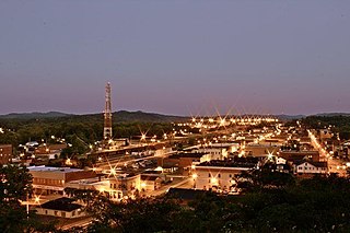
Poplar Bluff is a city in Butler County in Southeast Missouri, United States. It is the county seat of Butler County and is known as "The Gateway to the Ozarks" among other names. The population was 16,225 at the 2020 census. The Poplar Bluff Micropolitan Statistical Area consists of all of Butler County. The city is at the crossroads of U.S. Route 60 and U.S. Route 67.
Corbin is a home rule-class city in Whitley, Knox and Laurel counties in the southeastern portion of the U.S. state of Kentucky. As of the 2020 census, the city population was 7,856.

Kentucky Route 11 (KY 11) is an American highway maintained by the Kentucky Transportation Cabinet that runs from Maysville to Barbourville. The route from Maysville to Mount Sterling is being upgraded on a new alignment as part of a "macro-corridor" within the state of Kentucky.

Knox County is a county located in Appalachia near the southeastern corner of the U.S. state of Kentucky. As of the 2020 census, the population was 30,193. Its county seat is Barbourville. The county is named for General Henry Knox. It is one of the few coal-producing counties in Kentucky that has not suffered massive population loss. Knox County is included in the London, KY Micropolitan Statistical Area.
Dorton is an unincorporated community and coal town in southern Pike County, Kentucky, United States. Located along U.S. Route 23, also known as Country Music Highway. It is centered at the confluence of Dorton and Shelby Creeks and the junction of U.S. 23 and KY 610, 13 miles south of Pikeville.

Kentucky Route 190 (KY 190) is a 21.5-mile-long (34.6 km) state highway in the U.S. state of Kentucky. The highway travels through rural areas of Bell County.

Kentucky Route 192 (KY 192) is a 40.5-mile-long (65.2 km) state highway in the U.S. state of Kentucky. The highway connects the Somerset area and the London areas with mostly rural areas of Pulaski and Laurel counties.

Kentucky Route 348 (KY 348) is a 20.566-mile-long (33.098 km) state highway in the U.S. state of Kentucky. The highway connects mostly rural areas of McCracken, Graves, and Marshall counties with Symsonia and Benton.


