Lowland | |
|---|---|
 Site of former Liberty Fibers/Enka/BASF plant in Lowland | |
 Lowland  Lowland | |
| Coordinates: 36°09′29″N83°12′30″W / 36.15806°N 83.20833°W | |
| Country | United States |
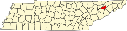
| State | Tennessee |
| County | Hamblen |
| Named after | American Enka Company Lowland factory [1] |
| Elevation | 1,050 ft (320 m) |
| Time zone | UTC-5 (Eastern (EST)) |
| • Summer (DST) | UTC-4 (EDT) |
| ZIP code | 37813 |
| Area code | 423 |
| GNIS feature ID | 1292236 [2] |
Lowland is an unincorporated community in Hamblen County, Tennessee.