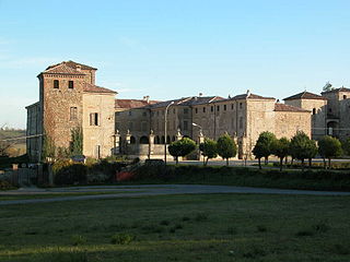
Agazzano is a comune (municipality) in the Province of Piacenza in the Italian region Emilia-Romagna, located about 150 kilometres (93 mi) northwest of Bologna and about 20 kilometres (12 mi) southwest of Piacenza. As of 31 December 2004, it had a population of 2,021 and an area of 35.9 square kilometres (13.9 sq mi).

Alseno is a comune (municipality) in the Province of Piacenza in the Italian region Emilia-Romagna, located about 120 kilometres (75 mi) northwest of Bologna and about 25 kilometres (16 mi) southeast of Piacenza.

Besenzone is a comune (municipality) in the Province of Piacenza in the Italian region Emilia-Romagna, located about 120 kilometres (75 mi) northwest of Bologna and about 20 kilometres (12 mi) southeast of Piacenza.

Borgonovo Val Tidone is a comune (municipality) in the Province of Piacenza in the Italian region Emilia-Romagna, located about 160 kilometres (99 mi) northwest of Bologna and about 20 kilometres (12 mi) west of Piacenza.

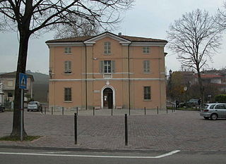
Cadeo is a town and comune (municipality) in the Province of Piacenza in the Italian region Emilia-Romagna, located about 130 kilometres (81 mi) northwest of Bologna and about 14 kilometres (9 mi) southeast of Piacenza. It has about 5,600 inhabitants. The name is derived from Italian, meaning "House of God." This refers to a time when Cadeo was a stop-over for Christian pilgrims. The photo of the church accompanying this article is actually on the Via Emilia in Roveleto.

Castelvetro Piacentino, also known as Castelvetro, is a town and comune (municipality) in the Province of Piacenza in the Italian region Emilia-Romagna, located about 130 kilometres (81 mi) northwest of Bologna and about 25 kilometres (16 mi) east of Piacenza.
Ferriere is a comune (municipality) in the Province of Piacenza in the Italian region Emilia-Romagna, located about 150 kilometres (93 mi) west of Bologna and about 45 kilometres (28 mi) southwest of Piacenza, in the Val Nure of the Ligurian Appennines.
Monticelli d'Ongina is a comune (municipality) in the Province of Piacenza in the Italian region Emilia-Romagna, located about 130 kilometres (81 mi) northwest of Bologna and about 20 kilometres (12 mi) east of Piacenza.
Morfasso is a comune (municipality) in the Province of Piacenza in the Italian region Emilia-Romagna, located about 130 kilometres (81 mi) west of Bologna and about 35 kilometres (22 mi) south of Piacenza. As of 31 December 2011, it had a population of 1,090 and an area of 83.6 square kilometres (32.3 sq mi).

Pianello Val Tidone is a comune (municipality) in the Province of Piacenza in the Italian region Emilia-Romagna, located about 160 kilometres (99 mi) northwest of Bologna and about 25 kilometres (16 mi) southwest of Piacenza.
Piozzano is a comune (municipality) in the Province of Piacenza in the Italian region Emilia-Romagna, located about 150 kilometres (93 mi) northwest of Bologna and about 20 kilometres (12 mi) southwest of Piacenza.

Pontenure is a comune (municipality) in the Province of Piacenza in the Italian region Emilia-Romagna, located about 140 kilometres (87 mi) northwest of Bologna and about 9 kilometres (6 mi) southeast of Piacenza.
San Giorgio Piacentino is a comune (municipality) in the Province of Piacenza in the Italian region Emilia-Romagna, located about 140 kilometres (87 mi) northwest of Bologna and about 11 kilometres (7 mi) south of Piacenza.
San Pietro in Cerro is a comune (municipality) in the Province of Piacenza in the Italian region Emilia-Romagna, located about 120 kilometres (75 mi) northwest of Bologna and about 20 kilometres (12 mi) east of Piacenza. As of 31 December 2004, it had a population of 962 and an area of 27.5 square kilometres (10.6 sq mi).

Travo is a comune (municipality) in the Province of Piacenza in the Italian region Emilia-Romagna, located about 150 kilometres (93 mi) northwest of Bologna and about 25 kilometres (16 mi) southwest of Piacenza. It is on the left bank of the Trebbia river.

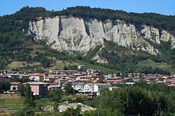
Vernasca is a comune (municipality) in the Province of Piacenza in the Italian region Emilia-Romagna, located about 120 kilometres (75 mi) northwest of Bologna and about 30 kilometres (19 mi) southeast of Piacenza.
Villanova sull'Arda is a comune (municipality) in the Province of Piacenza in the Italian region Emilia-Romagna, located about 120 kilometres (75 mi) northwest of Bologna and about 25 kilometres (16 mi) east of Piacenza.

Ziano Piacentino is a comune (municipality) in the Province of Piacenza in the Italian region Emilia-Romagna, located about 160 kilometres (99 mi) northwest of Bologna and about 25 kilometres (16 mi) west of Piacenza. Ziano Piacentino borders the following municipalities: Alta Val Tidone, Borgonovo Val Tidone, Castel San Giovanni, Rovescala, Santa Maria della Versa.