This article needs additional citations for verification .(July 2009) (Learn how and when to remove this template message) |
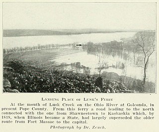
Lusk's Ferry Road was an early road in Illinois that provided an overland connection between the main settlement, Fort Kaskaskia, on the Mississippi River, and Lusk's Ferry, an important crossing point on the Ohio River. The overland route afforded an alternative to the river route, which required a difficult trip upstream on the Mississippi.

Illinois is a state in the Midwestern and Great Lakes region of the United States. It has the fifth largest gross domestic product (GDP), the sixth largest population, and the 25th largest land area of all U.S. states. Illinois is often noted as a microcosm of the entire United States. With Chicago in northeastern Illinois, small industrial cities and immense agricultural productivity in the north and center of the state, and natural resources such as coal, timber, and petroleum in the south, Illinois has a diverse economic base, and is a major transportation hub. Chicagoland, Chicago's metropolitan area, encompasses over 65% of the state's population. The Port of Chicago connects the state to international ports via two main routes: from the Great Lakes, via the Saint Lawrence Seaway, to the Atlantic Ocean and from the Great Lakes to the Mississippi River, via the Illinois Waterway to the Illinois River. The Mississippi River, the Ohio River, and the Wabash River form parts of the boundaries of Illinois. For decades, Chicago's O'Hare International Airport has been ranked as one of the world's busiest airports. Illinois has long had a reputation as a bellwether both in social and cultural terms and, through the 1980s, in politics.

Kaskaskia is a historically important village in Randolph County, Illinois, United States. In the 2010 census the population was 14, making it the second-smallest incorporated community in the State of Illinois in terms of population, behind Valley City. As a major French colonial town of the Illinois Country, in the 18th century its peak population was about 7,000, when it was a regional center. During the American Revolutionary War, the town, which by then had become an administrative center for the British Province of Quebec, was taken by the Virginia militia during the Illinois campaign. It was designated as the county seat of Illinois County, Virginia, after which it became part of the Northwest Territory in 1787. Kaskaskia was later named as the capital of the United States' Illinois Territory, created on February 3, 1809. In 1818, when Illinois became the 21st U.S. state, the town briefly served as the state's first capital until 1819, when the capital was moved to more centrally located Vandalia.

The Mississippi River is the second-longest river and chief river of the second-largest drainage system on the North American continent, second only to the Hudson Bay drainage system. Its source is Lake Itasca in northern Minnesota and it flows generally south for 2,320 miles (3,730 km) to the Mississippi River Delta in the Gulf of Mexico. With its many tributaries, the Mississippi's watershed drains all or parts of 32 U.S. states and two Canadian provinces between the Rocky and Appalachian mountains. The main stem is entirely within the United States; the total drainage basin is 1,151,000 sq mi (2,980,000 km2), of which only about one percent is in Canada. The Mississippi ranks as the fourth-longest and fifteenth-largest river by discharge in the world. The river either borders or passes through the states of Minnesota, Wisconsin, Iowa, Illinois, Missouri, Kentucky, Tennessee, Arkansas, Mississippi, and Louisiana.
Contents
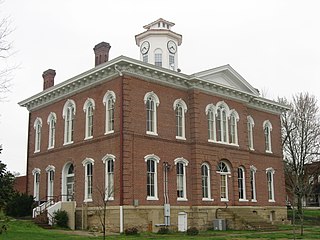
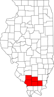
- Randolph County
- Perry County
- Jackson County
- Franklin County
- Williamson County
- Mocassin Gap/Johnson County
- Pope County
- Notes
- See also
- References
- External links
Fort Massac is on the Ohio River, about 20 miles (overland) southwest of Lusk's Ferry. This was a French fort that was abandoned and burned in 1763, at the end of the French and Indian War, when control of the Illinois Country passed to the British. It is likely that the Lusk's Ferry road started as a French road that connected Fort Massac with Fort Kaskaskia. After Lusk's Ferry came into use, a road was built from the Ferry to the Fort Massac Road. With the Fort abandoned, the southern stretch of the road fell into disuse, and the road became the Lusk's Ferry Road.

Fort Massac was a French colonial and early National-era fort on the Ohio River in Massac County, Illinois, United States.

The French and Indian War (1754–1763) pitted the colonies of British America against those of New France, each side supported by military units from the parent country and by American Indian allies. At the start of the war, the French colonies had a population of roughly 60,000 settlers, compared with 2 million in the British colonies. The outnumbered French particularly depended on the Indians.

The Illinois Country — sometimes referred to as Upper Louisiana — was a vast region of New France in what is now the Midwestern United States. While these names generally referred to the entire Upper Mississippi River watershed, French colonial settlement was concentrated along the Mississippi and Illinois Rivers in what is now the U.S. states of Illinois and Missouri, with outposts in Indiana. Explored in 1673 from Green Bay to the Arkansas River by the Canadien expedition of Louis Jolliet and Jacques Marquette, the area was claimed by France. It was settled primarily from the Pays d'en Haut in the context of the fur trade. Over time, the fur trade took some French to the far reaches of the Rocky Mountains, especially along the branches of the broad Missouri River valley. The French name, Pays des Illinois, means "Land of the Illinois [plural]" and is a reference to the Illinois Confederation, a group of related Algonquian native peoples.
In his conquest of Illinois in 1778 and 1789, George Rogers Clark, with the army of Virginia, crossed the Ohio River from Kentucky to Fort Massac. From there he headed north to the Lusk's Ferry Road, which he followed at least part of the way to Fort Kaskaskia, [1] whose defenses were oriented toward repelling an assault coming up the Mississippi. Clark was able to take the Fort by surprise by approaching from the interior of Illinois.

George Rogers Clark was an American surveyor, soldier, and militia officer from Virginia who became the highest ranking American military officer on the northwestern frontier during the American Revolutionary War. He served as leader of the militia in Kentucky throughout much of the war. He is best known for his celebrated captures of Kaskaskia (1778) and Vincennes (1779) during the Illinois Campaign, which greatly weakened British influence in the Northwest Territory. The British ceded the entire Northwest Territory to the United States in the 1783 Treaty of Paris, and Clark has often been hailed as the "Conqueror of the Old Northwest".

Virginia, officially the Commonwealth of Virginia, is a state in the Southeastern and Mid-Atlantic regions of the United States located between the Atlantic Coast and the Appalachian Mountains. Virginia is nicknamed the "Old Dominion" due to its status as the first English colonial possession established in mainland North America and "Mother of Presidents" because eight U.S. presidents were born there, more than any other state. The geography and climate of the Commonwealth are shaped by the Blue Ridge Mountains and the Chesapeake Bay, which provide habitat for much of its flora and fauna. The capital of the Commonwealth is Richmond; Virginia Beach is the most populous city, and Fairfax County is the most populous political subdivision. The Commonwealth's estimated population as of 2018 is over 8.5 million.

Kentucky, officially the Commonwealth of Kentucky, is a state located in the east south-central region of the United States. Although styled as the "State of Kentucky" in the law creating it, (because in Kentucky's first constitution, the name state was used) Kentucky is one of four U.S. states constituted as a commonwealth. Originally a part of Virginia, in 1792 Kentucky became the 15th state to join the Union. Kentucky is the 37th most extensive and the 26th most populous of the 50 United States.
The northwestern and southeastern segments of the Lusk's Ferry Road, close to Kaskaskia and Lusk's Ferry, were accurately mapped in the early surveys of Illinois, which were conducted around 1800. This survey was oriented toward marking out "Townships" that were six miles (10 km) square, subdivided into "Sections" that were one mile (1.6 km) square, pursuant to the Land Ordinance of 1785. Although the surveyors were not charged with mapping the roads, many did so. The locations of the roads were probably exact where they met the Section lines, about once every mile, and approximated between these points. The actual maps were drawn in the 1830s, but were based on the surveyors' notes from around 1800.

The Land Ordinance of 1785 was adopted by the United States Congress of the Confederation on May 20, 1785. It set up a standardized system whereby settlers could purchase title to farmland in the undeveloped west. Congress at the time did not have the power to raise revenue by direct taxation, so land sales provided an important revenue stream. The Ordinance set up a survey system that eventually covered over 3/4 of the area of the continental United States.
The Lusk Ferry Road was a very old road, at least by Illinois standards, being present before the original survey. It is, however, notable that, on its northwestern end, this was a carefully surveyed road. It ran east out of Kaskaskia mostly in segments that ran nearly due east, almost to modern DuQuoin, where it made a sharp turn to the southeast, running for miles on a very straight line directly toward Fort Massac and Lusk's Ferry. Although the road jogged to avoid obstacles, it did not follow the natural lay of the land like animal trails, Indian trails and most pioneer roads. This was an engineered road that was not equaled in Illinois until many decades after the original survey. This suggests that the road had its origin as a military road connecting Fort Kaskaskia with Fort Massac. The road may have been laid out by the French in the 1750s, or by the Americans after the reoccupation of Fort Massac in 1794.
The direction of the road was controlled by several factors. Out of Kaskaskia, the road went north toward the headwaters of Marys River, avoiding a river crossing. The road then headed east to cross the Big Muddy River as far upstream as possible consistent with a direct route to the southeast. After crossing the Big Muddy, the road seems to aim straight for the most direct pass over the Shawnee Hills.
Marys River is a tributary of the Mississippi River in Illinois. It drains a small watershed between the Big Muddy River and the Kaskaskia River. It joins the Mississippi just southeast of Chester, near Kaskaskia. Because of its proximity to Kaskaskia — the capital of Illinois Territory and the first capital of the State of Illinois — Marys River was the site of early settlements leading into the interior of Illinois.

The Big Muddy River is a 156-mile-long (251 km) river in southern Illinois. It joins the Mississippi River just south of Grand Tower. The Big Muddy has been dammed near Benton, forming Rend Lake.

The Shawnee Hills is a region of southern Illinois that rests mainly in an east-west arc roughly following the outline of the southern end of the Illinois Basin. Whereas Mississippian and Pennsylvania Age rock layers are deep beneath the surface in central Illinois, these strata pierce the surface in southern Illinois. The Shawnee Hills are surface expressions of the more weather-resistant limestone and sandstone layers.
The Big Muddy crossing was a major limitation on this road. Although bridges over the Big Muddy existed in the area in the early 19th century, there is no reference to a bridge on the Lusk's Ferry Road. Even if there was a bridge, the Big Muddy is notable for its broad, flat floodplain. A true all weather route would have required long causeways over the floodplain that would have been more than a mile long.
In wet weather, there were two options. One would be to go down the Mississippi and up the Ohio by boat. The other would have been to follow the Fort Vincennes road northeast to the Goshen Road, and then southeast to Old Shawneetown, Illinois. Although this would have been at least eighty miles farther, there were no river crossings.
Goshen Road was an early road that ran from Old Shawneetown, Illinois, on the Ohio River, northwest to the Goshen Settlement, near Glen Carbon, Illinois, near the Mississippi River. In the early 19th century, this was the main east/west road in Illinois.

Old Shawneetown is a village in Gallatin County, Illinois, United States. As of the 2010 census, the village had a population of 193, down from 278 at the 2000 census. Located along the Ohio River, Shawneetown served as an important United States government administrative center for the Northwest Territory. The village was devastated by the Ohio River flood of 1937. The village's population was moved several miles inland to New Shawneetown.