Lux, Mississippi | |
|---|---|
 Lux  Lux | |
| Coordinates: 31°26′43″N89°24′03″W / 31.44528°N 89.40083°W | |
| Country | United States |
| State | Mississippi |
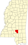
| County | Covington |
| Elevation | 190 ft (60 m) |
| Time zone | UTC-6 (Central (CST)) |
| • Summer (DST) | UTC-5 (CDT) |
| Area codes | 601 & 769 |
| GNIS feature ID | 692026 [1] |
Lux, also known as Bryant or Wheelerville, is an unincorporated community in Covington County, Mississippi, United States. Lux is located on the former Gulf and Ship Island Railroad and was once home to a lumber mill. [2] Lux was also formerly home to a school. [3]