Ora, Mississippi | |
|---|---|
 Ora  Ora | |
| Coordinates: 31°39′28″N89°34′28″W / 31.65778°N 89.57444°W | |
| Country | United States |
| State | Mississippi |
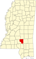
| County | Covington |
| Elevation | 299 ft (91 m) |
| Time zone | UTC-6 (Central (CST)) |
| • Summer (DST) | UTC-5 (CDT) |
| Area codes | 601 & 769 |
| GNIS feature ID | 675300 [1] |
Ora is an unincorporated community in Covington County, Mississippi, United States. It was incorporated in 1901 and had a post office from 1890 until 1922. [2] Ora's population grew from 28 in 1900 to several hundred by 1920, and it was once home to six general stores, two lumber companies, and a sawmill. [3] It was a station on the Gulf and Ship Island Railroad. Closure of the station was requested in 1921. [4]