
M-37 is a north–south state trunkline highway in the US state of Michigan. The southern terminus is near the border between Kalamazoo and Calhoun counties at exit 92 of Interstate 94 (I-94) southwest of Battle Creek. The northern terminus is at the Mission Point Light on Old Mission Point in Grand Traverse County. In between, the highway connects Battle Creek, Grand Rapids and Traverse City. Motorists will travel through agricultural land, forests, suburbs and large cities along the way. The section of M-37 on the Old Mission Peninsula was designated what is now a Pure Michigan Scenic Byway in 2008.

M-89 is an east–west state trunkline highway in the US state of Michigan that runs from near Ganges to Battle Creek. M-89 starts at an interchange with Interstate 196/US Highway 31 (I-196/US 31) and passes through Allegan, Kalamazoo County, Michigan, and Calhoun counties. The highway also briefly crosses the southwest corner of Barry County before it terminates an at intersection with Business Loop I-94 on the northwestern side of downtown Battle Creek. In between the trunkline runs parallel to the Kalamazoo River through rural southwestern Michigan farmlands while also running through the middle of several smaller towns in the area.

M-21 is an east–west state trunkline highway in the US state of Michigan connecting the cities of Grand Rapids and Flint. The highway passes through rural farming country and several small towns along its course through the Lower Peninsula. Following the course of a handful of rivers, M-21 also connects some of the state's freeways like Interstate 96 (I-96), US Highway 127 (US 127) and I-75. The highway is used by between 1,700 and 36,000 vehicles daily.
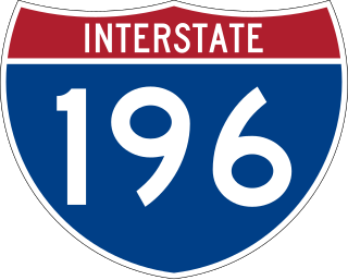
Interstate 196 (I-196) is an auxiliary Interstate Highway that runs for 80.6 miles (129.7 km) in the US state of Michigan. It is a state trunkline highway that links Benton Harbor, South Haven, Holland, and Grand Rapids. In Kent, Ottawa, and Allegan counties, I-196 is known as the Gerald R. Ford Freeway, or simply the Ford Freeway, after President Gerald Ford, who was raised in Grand Rapids and served Michigan in the House of Representatives for 25 years. This name generally refers only to the section between Holland and Grand Rapids. I-196 changes direction; it is signed as a north–south highway from its southern terminus to the junction with US Highway 31 (US 31) just south of Holland, and as an east–west trunkline from this point to its eastern terminus at an interchange with I-96, its parent highway. There are three business routes related to the main freeway. There are two business loops and one business spur that serve South Haven, Holland and the Grand Rapids areas. Another business spur for Muskegon had been designated relative to the I-196 number.

M-96 is a state trunkline highway in the US state of Michigan that runs between Kalamazoo and Marshall. Its termini are both on business routes of Interstate 94 (I-94); the eastern one coincides with an intersection with I-69. Between Kalamazoo and Marshall it passes through Comstock, Galesburg, Augusta, and Battle Creek intersecting I-194/M-66 in Battle Creek and I-94 in Emmett Township.

Interstate 296 (I-296) is a part of the Interstate Highway System in the US state of Michigan. It is a north–south state trunkline highway that runs for 3.43 miles (5.52 km) entirely within the Grand Rapids area. Its termini are I-196 near downtown Grand Rapids and I-96 on the north side of Grand Rapids in Walker. For most of its length, the Interstate runs concurrently with U.S. Highway 131 (US 131), which continues as a freeway built to Interstate Highway standards north and south of the shorter I-296. The highway was first proposed in the late 1950s and opened in December 1962, but the Michigan Department of Transportation (MDOT) has since eliminated all signage for I-296 and removed the designation from their official state map. The designation is therefore unsigned, but still listed on the Interstate Highway System route log maintained by the Federal Highway Administration (FHWA).
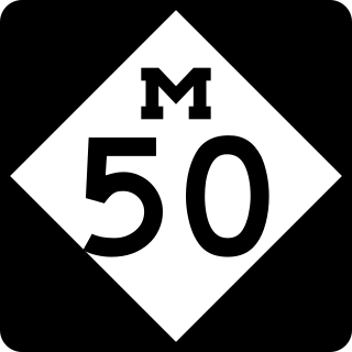
M-50 is a state trunkline highway in the US state of Michigan. Although designated as an east–west highway, it is nearly a diagonal northwest–southeast route. The western terminus is at exit 52 along Interstate 96 (I-96) near Alto a few miles east of the metro Grand Rapids area, and its eastern terminus is in downtown Monroe at US Highway 24. In between the trunkline runs through seven counties of the southern part of the Lower Peninsula mostly through rural farm fields and small communities. The highway also runs through downtown Jackson to connect between two freeway sections of US 127. In the Irish Hills area of the state southeast of Jackson, M-50 runs next to Michigan International Speedway.
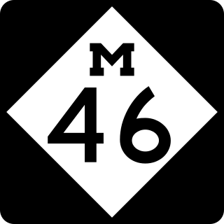
M-46 is an east–west state trunkline highway in the US state of Michigan between Muskegon and Port Sanilac, terminating near Lake Michigan and Lake Huron on each end. Except for the north–south segment that corresponds with the US Highway 131 (US 131) freeway between Cedar Springs and Howard City, M-46 is practically a due east–west surface highway. The road runs through rural sections of the Lower Peninsula connecting several freeways including US 31, US 131, US 127 and Interstate 75 (I-75).

M-11 is a state trunkline highway in the US state of Michigan in the Grand Rapids metropolitan area. The highway runs through the western and southern sides of the metro area, starting over the border in Ottawa County at an interchange with Interstate 96 (I-96). It runs through both rural woodlands and busy commercial areas before it terminates at another interchange with I-96 in Cascade Township. Locally known as Wilson Avenue and 28th Street, the trunkline is listed on the National Highway System. M-11 carries between 8,000 and 42,000 vehicles on average each day.

Business M-28 is a state trunkline highway serving as a business route that runs for approximately 4.9 miles (7.9 km) through the downtown districts of Ishpeming and Negaunee in the US state of Michigan. The trunkline provides a marked route for traffic diverting from U.S. Highway 41 (US 41) and M-28 through the two historic iron-mining communities. It is one of three business loops for M-numbered highways in the state of Michigan. There have previously been two other Bus. M-28 designations for highways in Newberry and Marquette.
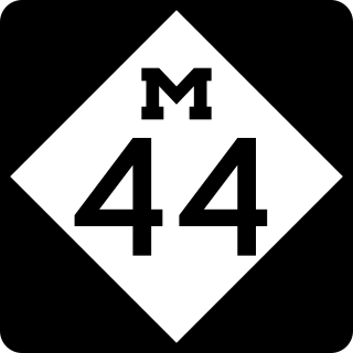
M-44 is a 37.463-mile (60.291 km) state trunkline highway in the western region of the US state of Michigan. It runs northward from the intersection of M-11 and M-37 toward the Rockford area. The highway then turns eastward to Belding, and it ends six miles (10 km) north of Ionia at M-66. M-44 is known in Grand Rapids as the "East Beltline" and intersects with its related highway, Connector M-44, in Plainfield Township. This highway runs concurrently with M-37 between M-11 and Interstate 96 (I-96).

M-114 was the designation of a former state trunkline highway and planned beltline in the US state of Michigan around the city of Grand Rapids. It was designated by the end of 1929 on various streets in adjoining cities and townships. By the 1940s, sections of it on the west and south sides of Grand Rapids were given new designations and the segment along the east side of town was finished. By late 1945 the highway designation was completely decommissioned in favor of other numbers. M-114 split into two branches, one running east–west and the other running north–south. The east–west spur routing is now local streets while the rest is part of state highways.

M-121 is a state trunkline highway in West Michigan. The highway follows Chicago Drive, a local roadway, from Zeeland to Grandville. Chicago Drive itself runs past the M-121 segment on either side from Holland to Wyoming. The roadway passes through rural farmland on a route that runs parallel to Interstate 196 (I-196). M-121 forms the main street through the center of Hudsonville as it runs southwest–northeast. It forms a major street through the unincorporated community of Jenison before M-121 terminates at I-196 in Grandville.
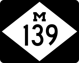
M-139 is a state trunkline highway entirely within Berrien County in the US state of Michigan. The highway starts at US Highway 12 (US 12) southwest of Niles and runs through rural areas of the county to terminate at an intersection with Business Loop Interstate 94 in Benton Harbor. The highway runs parallel to the St. Joseph River, crossing the river several times as it follows a set of roads previously used for US 31 in the area. The highway was first designated in the 1930s as a bypass of the Benton Harbor and St. Joseph area. Its termini have been moved over the years since, extending and contracting the length of the highway between Niles and Benton Harbor. M-139 now serves to provide access through the area from a set of bypasses consisting of I-94 and US 31.

There are currently eight business routes of Interstate 94 (I-94) in the US state of Michigan. These business routes connect I-94 to the downtown business districts of neighboring cities. Seven of the eight routes are business loops which bear the Business Loop I-94 designation while one is a business spur that bears the Business Spur I-94. These loops are former routings of I-94's two predecessors in Michigan: US Highway 12 (US 12) or US 25. The westernmost BL I-94 runs through the twin cities of Benton Harbor and St. Joseph along the former routing of US 12 and US 31/US 33 that now includes a section of the Lake Michigan Circle Tour in the state. The loops in Kalamazoo, Battle Creek, Marshall, Albion, and Jackson were also formerly segments of US 12 which were later designated as separate version of Business US Highway 12 through their respective cities before becoming BL I-94s in 1960. The BL I-94 in Kalamazoo was converted into BS I-94 in 2019. The route of the business loop through Ann Arbor was previously US 12 and then later M-14 before receiving its current moniker. The BL I-94 through Port Huron was previously US 25 and then Business US Highway 25.

There are six business routes of US Highway 131 in the state of Michigan, and previously there was one bypass route and an additional business route. All of the business routes are former sections of US Highway 131 (US 131). These former sections of the mainline highway, along with the necessary connecting roads, allow traffic to access the downtowns business districts of cities bypassed by sections of US 131 built since the 1950s. The extant business loops connect to Constantine, Three Rivers, Kalamazoo, Big Rapids, Cadillac, and Manton. The former bypass route in Grand Rapids allowed traffic to bypass that city's downtown at a time when US 131 still ran through the heart of the city, and the later business route connected through downtown while US 131 ran on a freeway bypassing the central business district.
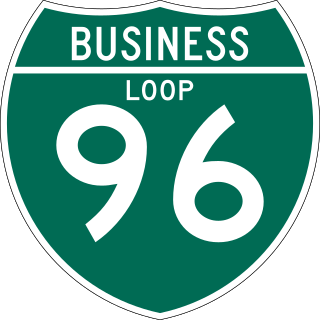
There have been six business routes of Interstate 96 (I-96) in the US state of Michigan. There are two business loops designated Business Loop Interstate 96 : one through Lansing and one through Howell. Both follow the old route of US Highway 16 (US 16), with appropriate connections to I-96. There are three former business spurs that were designated Business Spur Interstate 96. One connected to the carferry docks in Muskegon, running concurrently with part of Business US 31 along former US 16, but it has been eliminated. The second spur ran into downtown Portland until it was decommissioned in 2007. Two routes in the Detroit area—a loop through Farmington and a spur into Detroit—both using Grand River Avenue, and meeting at the temporary end of I-96 near Purdue Avenue, were eliminated when I-96 was moved to the completed Jeffries Freeway in 1977. The Farmington business route is still state-maintained as an unsigned highway, while the Detroit business route remained unsigned until it was decommissioned in 2016 and replaced by an extension of M-5.

There have been seven business routes of US Highway 31 in the state of Michigan. All of the business routes are former sections of US Highway 31 (US 31). They connect the freeway mainline of US 31 to the various downtowns of cities bypassed by US 31. Two of the current business routes, for Hart and Ludington, are business spurs, connecting to US 31 on only one end, while the remainder for Muskegon, Whitehall–Montague and Pentwater, are business loops. The two former routes, for Niles and Holland were a business spur and loop, respectively.

