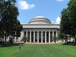
The area around the campus of the Massachusetts Institute of Technology, or MIT, makes up Area 2 of Cambridge, Massachusetts. Area 2 is bounded by Main Street and Broadway on the north, the railroad tracks on the west, and the Charles River on the south and east. Its population in 2005 was 5,486 residents living in 794 households. The average household income was $37,287.
Massachusetts Institute of Technology (MIT) is a private research university in Cambridge, Massachusetts. The Institute is a land-grant, sea-grant, and space-grant university, with an urban campus that extends more than a mile (1.6 km) alongside the Charles River. The Institute also encompasses a number of major off-campus facilities such as the MIT Lincoln Laboratory, the Bates Center, and the Haystack Observatory, as well as affiliated laboratories such as the Broad and Whitehead Institutes. Founded in 1861 in response to the increasing industrialization of the United States, MIT adopted a European polytechnic university model and stressed laboratory instruction in applied science and engineering. It has since played a key role in the development of many aspects of modern science, engineering, mathematics, and technology, and is widely known for its innovation and academic strength, making it one of the most prestigious institutions of higher learning in the world.
Cambridge is a city in Middlesex County, Massachusetts, and part of the Boston metropolitan area.
Middlesex County is a county in the Commonwealth of Massachusetts, in the United States. As of 2018, the estimated population was 1,614,714, making it the 22nd most populous county in the United States, and the most populous county in both Massachusetts and New England. As part of the 2010 national census, the Commonwealth's mean center of population for that year was geo-centered in Middlesex County, in the town of Natick at. Middlesex County is included in the Census Bureau’s Boston–Cambridge–Newton, MA–NH Metropolitan Statistical Area.
East Pepperell is a census-designated place (CDP) in the town of Pepperell in Middlesex County, Massachusetts, United States. The population was 2,059 at the 2010 census.
Littleton Common is a census-designated place (CDP) in the town of Littleton in Middlesex County, Massachusetts, United States. The population was 2,789 at the 2010 census.
Pinehurst is an unincorporated village and census-designated place (CDP) in the town of Billerica, Middlesex County, Massachusetts, United States. The population was 7,152 at the 2010 census. It is located in the southeastern part of town along Massachusetts Route 3A between the Shawsheen River and the Burlington town line.
West Concord is an unincorporated village and census-designated place (CDP) in the town of Concord in Middlesex County, Massachusetts, United States. The population was 6,028 at the 2010 census.
Cordaville is a census-designated place (CDP) in the town of Southborough in Worcester County, Massachusetts, United States. The population was 2,650 at the 2010 census.
Lunenburg is a census-designated place (CDP) in the town of Lunenburg in Worcester County, Massachusetts, United States. The population was 1,760 at the 2010 census.
Rutland is a census-designated place (CDP) in the town of Rutland in Worcester County, Massachusetts, United States. The population was 2,111 at the 2010 census.
Cambridgeport is one of the neighborhoods of Cambridge, Massachusetts. It is bounded by Massachusetts Avenue, the Charles River, the Grand Junction Railroad, and River Street. The neighborhood contains predominantly residential homes, many of the triple decker style common in New England. Central Square, at the northernmost part of Cambridgeport, is an active commercial district and transportation hub, and University Park is a collection of renovated or recently constructed office and apartment buildings. The neighborhood also includes Fort Washington Park, several MIT buildings, and Magazine Beach.
Grendel's Den is a bar and restaurant in Harvard Square in Cambridge, Massachusetts, located at 89 Winthrop Street. The establishment is frequented by both students and professors of Harvard University as well as many others from the Cambridge and Boston area. The name was a reference to Grendel, the antagonist in the Old English epic poem of Beowulf.
Mid-Cambridge, also known as "Area 6", is a neighborhood of Cambridge, Massachusetts. It is bounded by Massachusetts Avenue on the south and west, Prospect Street on the east, and Hampshire Street, the Somerville border, Kirkland Street, Quincy Street, and Cambridge Street on the north.
Riverside, also known as "Area 7", is a neighborhood of Cambridge, Massachusetts bounded by Massachusetts Avenue on the east, River Street on the south, the Charles River on the west, and JFK Street on the north. In 2005 it had a population of 11,201 residents in 3,341 households, and the average household income was $40,753.
Agassiz, also called Harvard North or "Area 8" or "Agassiz/Baldwin", is an unincorporated section of the city of Cambridge, Massachusetts, United States and as one of the thirteen sections (neighborhoods) that make up the City of Cambridge. Bounded by Massachusetts Avenue on the west, Cambridge Street, Quincy Street, and Kirkland Street on the south, Porter Square on the north, and the Somerville border on the northeast. It contains the Maria L. Baldwin Elementary School, formerly known as the Agassiz School.
West Cambridge, also known as "Area 10", is a neighborhood in Cambridge, Massachusetts. It is bounded by the Charles River on the south, JFK Street on the east, Concord Avenue on the north, and Fresh Pond, Aberdeen Avenue, and the Watertown line on the west.
North Cambridge, also known as "Area 11", is a neighborhood of Cambridge, Massachusetts bounded by Porter Square and the Fitchburg Line railroad tracks on the south, the city of Somerville on the northeast, Alewife Brook and the town of Arlington on the northwest, and the town of Belmont on the west. In 2005 it had a population of 10,642 residents living in 4,699 households, and the average income was $44,784. In 2010, the racial demographics for the neighborhood were 57.6% White, 20% Black, 15.1% Asian/Pacific Islander, 7.3% Hispanic origin, 0.3% Native American, 2.4% other race.
Strawberry Hill, also known as Area 13, is a neighborhood in Cambridge, Massachusetts. It is bounded by the town of Belmont on the west, Watertown on the south, Aberdeen Avenue on the east, and Fresh Pond on the north. In 2017 it had a population of 2,585 residents living in 1,061 households, and the average household income was $74,107. The altitude is around 114 feet above sea level making it the highest natural altitude in Cambridge.
Hudson is a census-designated place (CDP) in the town of Hudson in Middlesex County, Massachusetts, United States. The population was 14,907 at the 2010 census.
Pepperell is a census-designated place (CDP) in the town of Pepperell in Middlesex County, Massachusetts, United States. The population was 2,504 at the 2010 census.
Shirley is a census-designated place (CDP) in the town of Shirley in Middlesex County, Massachusetts, United States. The population was 1,441 at the 2010 census.
Townsend is a census-designated place (CDP) in the town of Townsend in Middlesex County, Massachusetts, United States. The population was 1,128 at the 2010 census.
Coordinates: 42°21′35.1″N71°5′31.4″W / 42.359750°N 71.092056°W
A geographic coordinate system is a coordinate system that enables every location on Earth to be specified by a set of numbers, letters or symbols. The coordinates are often chosen such that one of the numbers represents a vertical position and two or three of the numbers represent a horizontal position; alternatively, a geographic position may be expressed in a combined three-dimensional Cartesian vector. A common choice of coordinates is latitude, longitude and elevation. To specify a location on a plane requires a map projection.
This Middlesex County, Massachusetts geography–related article is a stub. You can help Wikipedia by expanding it. |