| Magor Marsh Reserve | |
|---|---|
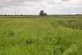
 Magor Marsh Nature Reserve in mid-May | |
 Magor Marsh Magor Marsh Nature Reserve | |
| Type | Nature Reserve |
| Location | Monmouthshire |
| Nearest city | Magor |
| OS grid | ST 428 866 |
| Coordinates | 51°34′34″N2°49′37″W / 51.576°N 2.827°W |
| Area | 36 hectares (0.360 km2; 0.139 sq mi) |
| Operated by | Gwent Wildlife Trust |
| Hiking trails | The Dragonfly Trail and The Butterfly Trail |
| Website | Gwent Wildlife Trust |
Magor Marsh is a 36-hectare (90-acre) wetland reserve, located on the Welsh side of the Severn Estuary. It is managed by the Gwent Wildlife Trust. It has a great variety of habitats, including damp hay meadows, sedge fen, reed bed, scrub and wet woodland. There are also numerous reens and a large pond.
Contents
Magor Marsh Nature Reserve is the richest site in Wales for wetland beetles and soldier-flies, and its pattern of drainage ditches and other features have remained unchanged since the 14th century.[ citation needed ]
The nature reserve can be explored in Virtual Reality through the Gwent Wildlife Trust’s Digital Nature Reserves project. Digital guides can also be found at the reserve via QR codes which enable visitors to learn about the site and its wildlife during their visit. Click here to access the VR Experience in Welsh and English, as well as the Digital Guide web app.
Magor Marsh can also be seen 24/7 via live camera streaming on Gwent Wildlife Trust’s website. Stills are refreshed every five minutes.
In March 2020 the reserve was featured in the BBC One programme Countryfile . [1]