
California is a state in the Pacific Coast region of the United States. With over 39.3 million residents across a total area of approximately 163,696 square miles (423,970 km2), it is the most populous U.S. state and the third-largest by area, as well as the world's thirty-fourth-most-populous subnational entity. California is also the most populated subnational entity in North America, and has its state capital in Sacramento. The Greater Los Angeles area and the San Francisco Bay Area are the nation's second- and fifth-most-populous urban regions, with more than 18.7 million and 9.6 million residents respectively. Los Angeles is California's most populous city, and the country's second-most-populous, after New York City. California also has the nation's most populous county, Los Angeles County, and its largest county by area, San Bernardino County. The City and County of San Francisco is both the country's second most densely populated major city after New York City and the fifth-most-densely populated county, behind only four of the five New York City boroughs.

Los Angeles, officially the City of Los Angeles and often abbreviated as L.A., is the largest city in California. With an estimated population of nearly four million people, it is the second most populous city in the United States and the third most populous city in North America. Los Angeles is known for its Mediterranean climate, ethnic diversity, Hollywood entertainment industry, and its sprawling metropolis.
Orange usually refers to:
Southern California is a geographic and cultural region that generally comprises the southern portion of the U.S. state of California. It includes the Los Angeles metropolitan area, the second most populous urban agglomeration in the United States. The region generally contains ten of California's 58 counties: Imperial, Kern, Los Angeles, Orange, Riverside, San Bernardino, San Diego, Santa Barbara, San Luis Obispo and Ventura counties. The Colorado Desert and the Colorado River are located on southern California's eastern border with Arizona, and San Bernardino County shares a border with Nevada to the northeast. Southern California's southern border with Baja California is part of the Mexico–United States border.

The Baja California Peninsula is a peninsula in Northwestern Mexico. It separates the Pacific Ocean from the Gulf of California. The peninsula extends 1,247 km from Mexicali, Baja California in the north to Cabo San Lucas, Baja California Sur in the south. It ranges from 40 km at its narrowest to 320 km at its widest point and has approximately 3,000 km of coastline and approximately 65 islands. The total area of the Baja California Peninsula is 143,390 km2 (55,360 sq mi), roughly the same area as the country of Nepal.

U.S. Route 101, or U.S. Highway 101 (US 101), is a north–south United States Numbered Highway that runs through the states of California, Oregon, and Washington, on the West Coast of the United States. It is also known as El Camino Real where its route along the southern and central California coast approximates the old trail which linked the Spanish missions, pueblos, and presidios. It merges at some points with California State Route 1 (SR 1).
State Route 1 (SR 1) is a major north–south state highway that runs along most of the Pacific coastline of the U.S. state of California. At a total of just over 656 miles (1,056 km), it is the longest state route in California. SR 1 has several portions designated as either Pacific Coast Highway (PCH), Cabrillo Highway, Shoreline Highway, or Coast Highway. Its southern terminus is at Interstate 5 (I-5) near Dana Point in Orange County and its northern terminus is at U.S. Route 101 (US 101) near Leggett in Mendocino County. SR 1 also at times runs concurrently with US 101, most notably through a 54-mile (87 km) stretch in Ventura and Santa Barbara counties, and across the Golden Gate Bridge.
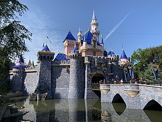
Anaheim is a city in Orange County, California, part of the Los Angeles metropolitan area. As of the 2010 United States Census, the city had a population of 336,265, making it the most populous city in Orange County, the 10th-most populous city in California, and the 55th-most populous city in the United States. Anaheim is the second-largest city in Orange County in terms of land area, and is known for being the home of the Disneyland Resort, the Anaheim Convention Center, and two major sports teams: the Anaheim Ducks ice hockey club and the Los Angeles Angels baseball team.

The Central Valley is a flat valley that dominates the interior of California. It is 40 to 60 miles wide and stretches approximately 450 miles (720 km) from north-northwest to south-southeast, inland from and parallel to the Pacific Ocean coast. It covers approximately 18,000 square miles (47,000 km2), about 11% of California's total land area. The valley is bounded by the Coast Ranges to the west and the Sierra Nevada to the east.
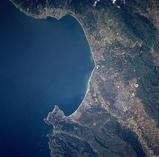
Monterey Bay is a bay of the Pacific Ocean located on the coast of the U.S. state of California. The bay is south of the major cities of San Francisco and San Jose. Santa Cruz is located at the north end of the bay, and Monterey is on the Monterey Peninsula at the south end. The "Monterey Bay Area" is a local colloquialism sometimes used to describe the whole of the Central Coast communities of Santa Cruz and Monterey counties.

South Gate is the 17th largest city in Los Angeles County, California, United States, with 7.4 square miles (19 km2). South Gate is located 7 miles (11 km) southeast of Downtown Los Angeles. It is part of the Gateway Cities region of southeastern Los Angeles County.

South Lake Tahoe is the most populous city in El Dorado County, California, United States, in the Sierra Nevada. The city's population was 21,403 at the 2010 census, down from 23,609 at the 2000 census. The city extends about 5 miles (8 km) west-southwest along U.S. Route 50, also known as Lake Tahoe Boulevard. The east end of the city, on the California–Nevada state line right next to the town of Stateline, Nevada, is mainly geared towards tourism, with T-shirt shops, restaurants, hotels, and Heavenly Mountain Resort with the Nevada casinos just across the state line in Stateline. The western end of town is mainly residential, and clusters around "The Y", the X-shaped intersection of US 50, State Route 89, and the continuation of Lake Tahoe Boulevard after it loses its federal highway designation.

Lake Tahoe is a large freshwater lake in the Sierra Nevada of the United States. Lying at 6,225 ft (1,897 m), it straddles the state line between California and Nevada, west of Carson City. Lake Tahoe is the largest alpine lake in North America, and at 122,160,280 acre⋅ft (150.7 km3) trails only the five Great Lakes as the largest by volume in the United States. Its depth is 1,645 ft (501 m), making it the second deepest in the United States after Crater Lake in Oregon.
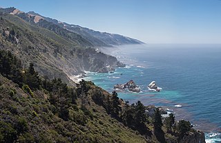
Big Sur is a rugged and mountainous section of the Central Coast of California between Carmel Highlands and San Simeon, where the Santa Lucia Mountains rise abruptly from the Pacific Ocean. It is frequently praised for its dramatic scenery. Big Sur has been called the "longest and most scenic stretch of undeveloped coastline in the contiguous United States", a sublime "national treasure that demands extraordinary procedures to protect it from development", and "one of the most beautiful coastlines anywhere in the world, an isolated stretch of road, mythic in reputation". The stunning views, redwood forests, hiking, beaches, and other recreational opportunities have made Big Sur a popular destination for about 7 million people who live within a day's drive and visitors from across the world. It is among the top 35 tourist destinations world-wide. The region receives about the same number of visitors as Yosemite National Park, but offers only limited bus service, few restrooms, and a narrow two-lane highway that for most of its length clings to the steep coastal cliffs. North-bound traffic during the peak summer season and holiday weekends is often backed up for about 20 miles (32 km) from Big Sur Village to Carmel. Due to the large number of visitors, congestion and slow traffic between Carmel and Posts is becoming the norm.
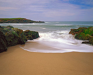
Bean Hollow State Beach is a beach in the state park system of California, USA. It is located in San Mateo County near Pescadero. The beach offers fishing, picnicking and beachcombing. Visitors can explore tide pools with anemones, crab, sea urchins and other marine inhabitants. The beach also has a self-guided nature trail. Swimming is dangerous because of cold water, rip currents, heavy surf and sharks. Bean Hollow is 17.5 miles (28.2 km) south of Half Moon Bay and 3 miles (4.8 km) south of Pescadero on State Route 1. The 44-acre (18 ha) property was acquired by the state in 1958.

Ward Creek is a 6.1-mile (9.8 km) eastward-flowing stream in Placer County, California, USA. The creek flows into Lake Tahoe 2.7 miles (4.3 km) south of Tahoe City, California, and has undergone extensive restoration to reduce sediment and surface run-off to maintain the purity of Lake Tahoe.
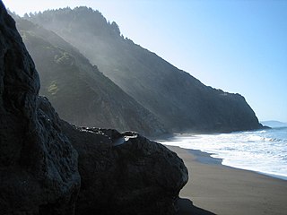
The Lost Coast is a mostly natural and undeveloped area of the California North Coast in Humboldt and Mendocino Counties, which includes the King Range. It was named the "Lost Coast" after the area experienced depopulation in the 1930s. In addition, the steepness and related geotechnical challenges of the coastal mountains made this stretch of coastline too costly for state highway or county road builders to establish routes through the area, leaving it the most undeveloped and remote portion of the California coast. Without any major highways, communities in the Lost Coast region such as Petrolia, Shelter Cove, and Whitethorn are isolated from the rest of California.

South Los Angeles, referred to as South-Central Los Angeles, is a region in southern Los Angeles County, California, lying mostly within the city limits of Los Angeles, just south of downtown. It is "defined on Los Angeles city maps as a 16-square-mile rectangle with two prongs at the south end.” In 2003, the Los Angeles City Council renamed this area "South Los Angeles".
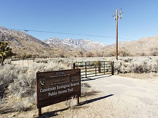
Canebrake Ecological Reserve is a 6,700-acre (27 km2) nature reserve in the South Fork Valley of Kern County, 20 miles (32 km) east of Lake Isabella, California. It is located in the Southern Sierra Nevada region.
