
Gerezani is an administrative ward of the Ilala Municipical Council of the Dar es Salaam Region in Tanzania. The Kariakoo and Mchikichini wards border the ward on its northern side. The ward is bordered by Mchafukoge to the east. Ilala ward borders the ward to the west. The ward is bordered to the south by the Keko and Kurasini wards of the Temeke District. Before 1940, the Gerezani ward was constructed for Railways Corporation's White employees. The Mkuki Mall and the Jakaya M. Kiwete Youth Park are located in the Gerezani ward. According to the 2022 census, the ward has a total population of 5,786.

Jangwani is an administrative ward of the Ilala Municipical Council of the Dar es Salaam Region in Tanzania. The Upanga East and Upanga West wards border the ward on its northern side. The ward is bordered by Mchafukoge and Kisutu to the east. Mchikichini ward borders the ward to the west. The ward is bordered to the south by the Kariakoo ward. According to the 2012 census, the ward has a total population of 17,647.

Kipawa is an administrative ward of the Ilala Municipical Council of the Dar es Salaam Region in Tanzania. Segerea and Kinyerezi border the ward on its northern border. The ward is bordered by Kiwalani to the east. By Kivule, Kitunda, and Yombo Vituka of Temeke MC to the south. Ukonga borders the ward on its western side. According to the 2022 census, the ward has a total population of 72,577.

Mchikichini is an administrative ward of the Ilala Municipical Council of the Dar es Salaam Region in Tanzania. Upanga West forms the ward's northern boundary. Its eastern border is formed by Jangwani and Kariakoo. The ward is bordered to the south by the Gerezani and Ilala wards. The Kinondoni District wards of Kigogo, Magomeni, and Mzimuni border it on the west. The ward is home to the Karume Market, one of the largest markest in the city. According to the 2012 census, the ward has a total population of 25,510.

Msongola is an administrative ward of the Ilala Municipical Council of the Dar es Salaam Region in Tanzania. Kivule and Chamazi border the ward to the north. By Chanika and Majohe to the west. Mkuranga and Tambani (Exclave) wards of the Mkuranga District of the Pwani Region border the ward on its southern side. The Main Tambani ward of Pwani Region's Mkuranga District borders the ward on the east. According to the 2012 census, the ward has a total population of 81,646.

Madukani is an administrative ward of the Dodoma Municipal Council of the Dodoma Region in Tanzania. Uhuru ward borders the ward on its northern side. Tambukareli and Viwandani border the ward to the east. Wards Kilimani and Hazina are to the south. Majengo ward borders the ward to the west. The Dodoma Regional Hospital, the biggest hospital in the region, is located in the ward. According to the 2012 census, the ward has a total population of 5,214.

Makole is an administrative ward of the Dodoma Municipal Council of the Dodoma Region in Tanzania. The Miyuji and Ipagala wards border the ward to the north and east, respectively. By Tambukareli and Viwandani to the south. The ward is bordered to the west by Kiwanja cha Ndege. According to the 2012 census, the ward has a total population of 10,504.

Tambukareli is an administrative ward of the Dodoma Municipal Council of the Dodoma Region in Tanzania. The ward is bordered to the north by the wards of Makole, Viwandani, and Ipagala. Dodoma Makulu borders the ward to the east, while Ntyuka ward borders it to the south. Kilimani and Madukani wards border the ward on its western side. The ward is home to the Tanzanian National Assembly, Bunge. According to the 2012 census, the ward has a total population of 6,584.

Uhuru is an administrative ward of the Dodoma Municipal Council of the Dodoma Region in Tanzania. The Chamwino and Kiwanja cha Ndege wards border the ward on its northern border. The ward is bordered by the Viwandani and Madukani wards to the east and south, respectively. Majengo ward borders the ward to the west. According to the 2012 census, the ward has a total population of 2,419.

Viwandani is an administrative ward of the Dodoma Municipal Council of the Dodoma Region in Tanzania. The ward is bordered to the north by the wards of Makole to the east and Kiwanja cha Ndege to the north. The Tambukareli ward is in the south. Uhuru, Chamwino, and Madukani wards are to the west. The ward is home the Gaddafi Mosque, Sabasaba Market and Nyerere Square. According to the 2012 census, the ward has a total population of 4,883.

Central is an administrative ward in Tanga City Council of Tanga Region in Tanzania. Tanga Bay borders the ward on its northern side. Pemba Channel lies to the east, and Mzingani, Usagara, Ngamiani Kaskazini, and Majengo ward are to the south. The Chumbageni ward is to the west. The ward covers an area of 3.8 km2 (1.5 sq mi), and has an average elevation of 10 m (33 ft). The ward seat is Halmashauri ya Jiji and is home to the Port of Tanga. According to the 2012 census, the ward has a total population of 5,739.

Chumbageni(Kata ya Chumbageni , in Swahili) is an administrative ward in Tanga City Council of Tanga Region in Tanzania. Tanga Bay and Mzizima Ward, which are separated by the Mkulumuzi River and Tanga Bay, border the ward to the north. Central ward is to the east. Majengo, Mwanzange, and Nguvumali wards are to the south. Kiomoni ward is to the west. The ward covers an area of 2.5 km2 (0.97 sq mi), and has an average elevation of 23 m (75 ft). According to the 2012 census, the ward has a total population of 14,225.
Majengo is an administrative ward in Tanga City Council of Tanga Region in Tanzania. Central encircles the ward on its northern side. Ngamiani Kaskazini, Ngamiani Kati, and Ngamiani Kusini are to the east. The ward of Mwanzange is to the south. Chumbageni and Nguvumali are to the west. The ward covers an area of 0.9 km2 (0.35 sq mi), and has an average elevation of 17 m (56 ft). According to the 2012 census, the ward has a total population of 7,482.
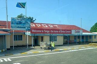
Mwanzange is an administrative ward in Tanga City Council of Tanga Region in Tanzania. The ward's northern boundaries are formed by Nguvumali and Chumbageni. Majengo and Msambweni border the ward on its eastern side. Duga ward and Tangasisi are to the south. Maweni is in the west. Tanga Airport is located entirely within Mwanzage's borders. The ward covers an area of 7.6 km2 (2.9 sq mi), and has an average elevation of 21 m (69 ft). According to the 2012 census, the ward has a total population of 7,521.

Ngamiani Kaskazini is an administrative ward in Tanga City Council of Tanga Region in Tanzania. Usagara and Central form the eastern and northern borders of the ward, respectively. Ngamiani Kati is to the south, and Majengo lies to the west. The ward covers an area of 0.3 km2 (0.12 sq mi), and has an average elevation of 10 m (33 ft). According to the 2012 census, the ward has a total population of 3,910.
Ngamiani Kusini is an administrative ward in Tanga City Council of Tanga Region in Tanzania. Ngamiani Kati forms the northern boundary of the ward. Usagara and Makorora border the ward to the east. Msambweni is in the south. Majengo and Mwanzange are located to the west. The ward covers an area of 0.4 km2 (0.15 sq mi), and has an average elevation of 15 m (49 ft). According to the 2012 census, the ward has a total population of 7,638.
Nguvumali is an administrative ward in Tanga City Council of Tanga Region in Tanzania. Chumbageni and Kiomoni form the northern and southern borders of the ward. Majengo forms the eastern boundary of the ward. Mwanzange lies to the south, while Maweni Ward is to the west. The ward covers an area of 5.7 km2 (2.2 sq mi), and has an average elevation of 26 m (85 ft). According to the 2012 census, the ward has a total population of 15,133.
Masuguru is an administrative ward in Tanga District of Tanga Region in Tanzania. The ward is part of the Muheza urban area. Tanganyika and Mbaramo form the northern and southern borders of the ward. East of this location is Majengo. Kwemkabala ward encircles the ward to the south and west. The ward covers an area of 0.3 km2 (0.12 sq mi), and has an average elevation of 200 m (660 ft). According to the 2012 census, the ward has a total population of 3,824.
Majengo is an administrative ward in Muheza District of Tanga Region in Tanzania. Tanganyika forms the northern boundary of the ward. Genge is in the east. Kilulu is to the south. Kwemkabala and Masuguru wards are to the west. The ward covers an area of 1.6 km2 (0.62 sq mi). According to the 2012 census, the ward has a total population of 6,992.
Kwemkabala is an administrative ward in Muheza District of Tanga Region in Tanzania. The ward is part of the Muheza urban area. North of the ward, Mbaramo, Masuguru, and Magila form its borders. East of here is Majengo. Kilulu is to the south. Tingeni is in the west. The ward covers an area of 3.2 km2 (1.2 sq mi), According to the 2012 census, the ward has a total population of 6,672.
