Malin Space Science Systems

Last updated

Malin Space Science Systems
(MSSS)
TypePrivately held company
Founded1990
Headquarters
San Diego, California
Key people
Michael C. Malin, CEO

Malin Space Science Systems (MSSS) is a San Diego, California-based private technology company that designs, develops, and operates instruments and technical equipment to fly on uncrewed spacecraft. MSSS is headed by chief scientist and CEO Michael C. Malin.

Contents

Founded in 1990, their first mission was the failed 1993 Mars Observer for which they developed and operated the Mars Observer Camera Ground Data System. After this mission they were selected to provide the main camera for Mars Global Surveyor. They also developed the cameras that were carried on Mars Polar Lander, Mars Climate Orbiter, 2001 Mars Odyssey, Mars Reconnaissance Orbiter and Phoenix lander.

Mars Color Imager on the Mars Reconnaissance Orbiter Mars Climate Orbiter - mco marci.jpg
Mars Color Imager on the Mars Reconnaissance Orbiter

One of the most successful of their instruments to date was the Mars Observer Camera (MOC), on board the Mars Global Surveyor placed into orbit around Mars in September 1997. From that date until November 2006, the MOC took more than 243,000 images of Mars, some at very high resolution. Among the MOCs notable successes was the imaging of the landing sites of the two Mars Exploration Rovers (the discarded heatshield of one of the rovers was located). Even before they landed, images from the MOC were very useful in picking the destinations of the two rovers.

After more than nine years of active duty, the Mars Global Surveyor ceased sending data back to Earth and it is now lost along with all its instruments, including the MOC.

For the Mars Reconnaissance Orbiter, launched on August 12, 2005, MSSS built the Mars Color Imager (MARCI) which takes wide angle, daily global views of Mars and the Context Imager (CTX) which has a six-metre resolution.

The Mars Science Laboratory was launched in 2011 and it carries three MSSS cameras. The MastCam is the main camera on board taking still and motion images of the surroundings. The 'HandLens Imager' is on the instrument arm and provides close up images of martian soil and rocks. Finally the Mars Descent Imager (MARDI) provided high resolution images of the ground during descent.

In December 2004, MSSS was selected to provide three cameras for the Lunar Reconnaissance Orbiter (2008) mission, under contract to Northwestern University. Recently, The MSSS has developed JunoCam for the Juno Jupiter Mission, which launched in 2011.

In July 2014, NASA announced the selection of the Mastcam-Z proposal for the Mars 2020 rover mission, provided by MSSS. It is an improved zoom version of the original MastCam. [1]

The Mars Orbiter Camera, built by Malin Space Science Systems and used by NASA on the Mars Observer and Mars Global Surveyor spacecraft. Mars Observer - MOC2 cb.jpg
The Mars Orbiter Camera, built by Malin Space Science Systems and used by NASA on the Mars Observer and Mars Global Surveyor spacecraft.

Liquid water on Mars

In June 2000, evidence for water currently under the surface of Mars was discovered in the form of flood-like gullies. [2] The question that was immediately asked was: is this an ongoing process or is this ancient and simply well preserved evidence of water/liquid flow? Most scientists agree that it is highly likely that water did flow on Mars in the distant past. [3]

Malin's camera controllers attempted to answer this question by taking photos of the same locations and in 2005 observation showed two areas where change had clearly occurred within the time of the photos (in other words, the activity was happening in present time and was not ancient).

On December 6, 2006, MSSS announced that it had discovered evidence that liquid water had likely flowed on Mars within the past five years. At a press conference, NASA showed images taken by the Mars Global Surveyor that suggested that water occasionally flows on the surface of Mars. The images did not actually show flowing water. Rather, they showed changes in craters and sediment deposits, providing the strongest evidence yet that water coursed through them as recently as several years ago, and is perhaps doing so even now. The findings were published in the December 8, 2006 issue of the journal Science . [4]

Malin Systems published several documents which describe what they found:

Before the December 2006 paper, some researchers were skeptical that liquid water was responsible for the surface features seen by the spacecraft. They said other materials such as sand or dust can flow like a liquid and produce similar results. At this stage, (late 2006) the flowing water hypothesis looks strong, however more evidence is needed. For more, see Life on Mars.

Geysers on Mars

Artist concept showing sand-laden jets erupt from geysers on Mars, producing 'dark dune spots'. (published by NASA; artist: Ron Miller. Geysers on Mars.jpg
Artist concept showing sand-laden jets erupt from geysers on Mars, producing 'dark dune spots'. (published by NASA; artist: Ron Miller.

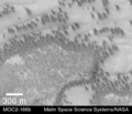
The MSSS cameras on board the Mars Global Surveyor, produced high resolution images that were also processed by Malin Space Science Systems, and discovered the intriguing polar features informally known as 'dark dune spots' and 'spiders'. [5] The origin of dark dune spots and the dark slope streaks emanating from them is yet uncertain, and various hypotheses have been put forward on their origin and formation process. The current model proposed by NASA and European teams propose cold geyser-like systems that eject CO2 and dark basaltic sand. The seasonal frosting of some areas near the southern ice cap results in the formation of transparent 1 metre thick slabs of dry ice above the ground. With the arrival of spring, sunlight warms the subsurface and pressure from subliming CO2 builds up under a slab, elevating and ultimately rupturing it. This leads to geyser-like eruptions of CO2 gas mixed with dark basaltic sand or dust. [6] [7] [8] [9] This process is rapid, observed happening in the space of a few days, weeks or months, a growth rate rather unusual in geology – especially for Mars. The gas rushing underneath a slab to the site of a geyser carves a spider-like pattern of radial channels under the ice.

List of products

Malin manufactured the following cameras for NASA spacecraft:

Related Research Articles

<i>Mars Global Surveyor</i> NASA Mars orbiter launched in 1996

Mars Global Surveyor (MGS) was an American robotic space probe developed by NASA's Jet Propulsion Laboratory and launched November 1996. MGS was a global mapping mission that examined the entire planet, from the ionosphere down through the atmosphere to the surface. As part of the larger Mars Exploration Program, Mars Global Surveyor performed atmospheric monitoring for sister orbiters during aerobraking, and helped Mars rovers and lander missions by identifying potential landing sites and relaying surface telemetry.

<span class="mw-page-title-main">Terra Cimmeria</span> Terra on Mars

Terra Cimmeria is a large Martian region, centered at 34.7°S 145°E and covering 5,400 km (3,400 mi) at its broadest extent. It covers latitudes 15 N to 75 S and longitudes 170 to 260 W. It lies in the Eridania quadrangle. Terra Cimmeria is one part of the heavily cratered, southern highland region of the planet. The Spirit rover landed near the area.

<span class="mw-page-title-main">Promethei Terra</span>

Promethei Terra is a large Martian region covering 3300 km at its broadest extent. It lies to the east of the massive Hellas basin. Like much of the southern part of the planet it is a heavily cratered, highland region. Promethei Terra was named for a classic albedo feature of Mars, with the original name derived from that of the Greek god Prometheus. Promethei Terra lies mostly in the Hellas quadrangle of Mars.

Michael C. Malin is an American astronomer, space scientist, and CEO of Malin Space Science Systems. His cameras have been important scientific instruments in the exploration of Mars.

<span class="mw-page-title-main">Geysers on Mars</span> Putative CO2 gas and dust eruptions on Mars

Martian geysers are putative sites of small gas and dust eruptions that occur in the south polar region of Mars during the spring thaw. "Dark dune spots" and "spiders" – or araneiforms – are the two most visible types of features ascribed to these eruptions.

<span class="mw-page-title-main">Diacria quadrangle</span> Map of Mars

The Diacria quadrangle is one of a series of 30 quadrangle maps of Mars used by the United States Geological Survey (USGS) Astrogeology Research Program. The quadrangle is located in the northwestern portion of Mars’ western hemisphere and covers 180° to 240° east longitude and 30° to 65° north latitude. The quadrangle uses a Lambert conformal conic projection at a nominal scale of 1:5,000,000 (1:5M). The Diacria quadrangle is also referred to as MC-2. The Diacria quadrangle covers parts of Arcadia Planitia and Amazonis Planitia.

<span class="mw-page-title-main">Eridania quadrangle</span> Map of Mars

The Eridania quadrangle is one of a series of 30 quadrangle maps of Mars used by the United States Geological Survey (USGS) Astrogeology Research Program. The Eridania quadrangle is also referred to as MC-29.

<span class="mw-page-title-main">Thaumasia quadrangle</span> Map of Mars

The Thaumasia quadrangle is one of a series of 30 quadrangle maps of Mars used by the United States Geological Survey (USGS) Astrogeology Research Program. The Thaumasia quadrangle is also referred to as MC-25 . The name comes from Thaumas, the god of the clouds and celestial apparitions.

<span class="mw-page-title-main">Argyre quadrangle</span> Map of Mars

The Argyre quadrangle is one of a series of 30 quadrangle maps of Mars used by the United States Geological Survey (USGS) Astrogeology Research Program. The Argyre quadrangle is also referred to as MC-26. It contains Argyre Planitia and part of Noachis Terra.

<span class="mw-page-title-main">Mare Australe quadrangle</span> Map of Mars

The Mare Australe quadrangle is one of a series of 30 quadrangle maps of Mars used by the United States Geological Survey (USGS) Astrogeology Research Program. The Mare Australe quadrangle is also referred to as MC-30. The quadrangle covers all the area of Mars south of 65°, including the South polar ice cap, and its surrounding area. The quadrangle's name derives from an older name for a feature that is now called Planum Australe, a large plain surrounding the polar cap. The Mars polar lander crash landed in this region.

<span class="mw-page-title-main">Asimov (crater)</span> Crater on Mars

Asimov Crater is an impact crater in the Noachis quadrangle of Mars, located at 47.0° S and 355.05° W. It is 84.0 km (52.2 mi) in diameter and was named after Isaac Asimov (1920–1992), an American biochemist and writer. The name was officially adopted on May 4, 2009.

<span class="mw-page-title-main">Gullies on Mars</span> Incised networks of narrow channels and sediments on Mars

Martian gullies are small, incised networks of narrow channels and their associated downslope sediment deposits, found on the planet of Mars. They are named for their resemblance to terrestrial gullies. First discovered on images from Mars Global Surveyor, they occur on steep slopes, especially on the walls of craters. Usually, each gully has a dendritic alcove at its head, a fan-shaped apron at its base, and a single thread of incised channel linking the two, giving the whole gully an hourglass shape. They are estimated to be relatively young because they have few, if any craters. A subclass of gullies is also found cut into the faces of sand dunes, that are themselves considered to be quite young. Linear dune gullies are now considered recurrent seasonal features.

<span class="mw-page-title-main">Mars Orbiter Camera</span> Scientific instruments on board the Mars Observer and Mars Global Surveyor spacecraft

The Mars Orbiter Camera and Mars Observer Camera (MOC) were scientific instruments on board the Mars Observer and Mars Global Surveyor spacecraft. The camera was built by Malin Space Science Systems (MSSS) for NASA and the cost of the whole MOC scientific investigation project was about US$44 million, higher than anticipated in the budget.

To date, interplanetary spacecraft have provided abundant evidence of water on Mars, dating back to the Mariner 9 mission, which arrived at Mars in 1971. This article provides a mission by mission breakdown of the discoveries they have made. For a more comprehensive description of evidence for water on Mars today, and the history of water on that planet, see Water on Mars.

The MOC Public Targeting Program was a very popular program that followed the Mars Global Surveyor's pictures of Mars. A total of 4,636 requests came in from the general public. Of these, 1,086 were photographed by the Mars Observer Camera. Many of the requests eventually resulted in publications. A little more than half of the requests came from a single member of the general public. One of the people wrote in the Planetary Report that working with MGS was as exciting as being a football fan able to run a few plays in the Super Bowl. Images from the Public Target program can be found at http://www.msss.com/moc_gallery/

The common surface features of Mars include dark slope streaks, dust devil tracks, sand dunes, Medusae Fossae Formation, fretted terrain, layers, gullies, glaciers, scalloped topography, chaos terrain, possible ancient rivers, pedestal craters, brain terrain, and ring mold craters.

<span class="mw-page-title-main">Mars Geyser Hopper</span> Proposed robotic mission to explore carbon dioxide geysers on Mars

The Mars Geyser Hopper (MGH) was proposed in 2012 as a NASA design reference mission for a Discovery-class spacecraft concept that would investigate the springtime carbon dioxide Martian geysers found in regions around the south pole of Mars.

<span class="mw-page-title-main">Copernicus (Martian crater)</span> Crater on Mars

Copernicus is a large crater on Mars, with a diameter close to 300 km. It is located south of the planet's equator in the heavily cratered highlands of Terra Sirenum in the Phaethontis quadrangle at 48.8°S and 191.2°E. Its name was approved in 1973, and it was named after Nicolaus Copernicus.

<span class="mw-page-title-main">Slipher (Martian crater)</span> Crater on Mars

Slipher is an impact crater in the Thaumasia quadrangle of Mars, located at 47.3°S latitude and 84.6°W longitude. It measures 127 kilometres (79 mi) in diameter and was named after American astronomers Vesto and Earl Slipher. The naming was approved by IAU's Working Group for Planetary System Nomenclature in 1973.

The following outline is provided as an overview of and topical guide to Mars:

References

  1. "NASA Selects MSSS to Provide Science Camera FOR 2020 Mars Rover Mission" . Retrieved September 10, 2015.
  2. Malin, Michael C., Edgett, Kenneth S., "Evidence for Recent Groundwater Seepage and Surface Runoff on Mars". Science (2000) Vol. 288. no. 5475, pp. 2330–2335.
  3. MSSS June 2000 article
  4. Scientists: Water likely flows on Mars, Associated Press , accessed on December 7, 2006
  5. Albee, A. L.; F. D. Palluconi; R. E. Arvidson (March 1998). "Mars Global Surveyor Mission: Overview and Status". Science. 279 (5357): 1671–1672. Bibcode:1998Sci...279.1671A. doi: 10.1126/science.279.5357.1671 . PMID   9497277.
  6. "NASA Findings Suggest Jets Bursting From Martian Ice Cap". Jet Propulsion Laboratory. NASA. August 16, 2006. Retrieved August 11, 2009.
  7. Kieffer, H. H. (2000). "Annual Punctuated CO2 Slab-Ice and Jets on Mars" (PDF). Mars Polar Science 2000 (1057): 93. Bibcode:2000mpse.conf...93K.
  8. Portyankina, G., ed. (2006). "Simulations of Geyser-Type Eruptions in Cryptic Region of Martian South" (PDF). Fourth Mars Polar Science Conference.
  9. Kieffer, Hugh H.; Philip R. Christensen and Timothy N. Titus; Titus, Timothy N. (May 30, 2006). "CO2 jets formed by sublimation beneath translucent slab ice in Mars' seasonal south polar ice cap". Nature. 442 (7104): 793–796. Bibcode:2006Natur.442..793K. doi:10.1038/nature04945. PMID   16915284. S2CID   4418194.