
Herrljunga Municipality is a municipality in Västra Götaland County in western Sweden. Its seat is located in the town of Herrljunga.

Nyírjákó is a village in Szabolcs-Szatmár-Bereg county, in the Northern Great Plain region of eastern Hungary.
Talya is a village (hobli) in the Holalkere taluk near Chitradurga district, Karnataka State, India.
Pozán de Vero is a municipality located in the province of Huesca, Aragon, Spain. According to the 2004 census (INE), the municipality has a population of 244 inhabitants.
Banasihalli is a small village in Hosadurga Taluk of Chitradurga district, Karnataka state, India. It is around 15 km from Hosadurga. Population is around 1000 and agriculture is the main occupation. Coconut and Arecanut are main agricultural products. The place is surrounded by rocky mountains. Lingayat is the main caste of people. There is a government primary school for education. The place is well connected to Hosadurga and Chitradurga by buses.
Nyaung-U is a district of the Mandalay Division in central Burma.
The Erskine Inlet is a natural waterway through the central Canadian Arctic Archipelago in Canada. It separates Cameron Island, Île Vanier, Massey Island and Alexander Island from Bathurst Island.

Abradasikatte is a village in the southern state of Karnataka, India. It is located in the Holalkere taluk of Chitradurga district in Karnataka.
Adavi Sangenahalli is a village in the southern state of Karnataka, India. It is located in the Hosadurga taluk of Chitradurga district in Karnataka.
Adavigollarahalli is a village in the southern state of Karnataka, India. It is located in the Chitradurga taluk of Chitradurga district in Karnataka.
Adiralu is a village in the southern state of Karnataka, India. It is located in the Hiriyur taluk of Chitradurga district in Karnataka.
Adrikatte is a village in the southern state of Karnataka, India. It is located in the Hosadurga taluk of Chitradurga district in Karnataka.
Tiszalúc is a village in Borsod-Abaúj-Zemplén County in northeastern Hungary.
Kaunispe is a village in Saaremaa Parish, Saare County in western Estonia.
Falkenhof Glacier is a tributary glacier 7 nautical miles (13 km) long, flowing west from the vicinity of Tricorn Mountain to enter Snakeskin Glacier northwest of Mount Clarke, Antarctica. It was named by the Advisory Committee on Antarctic Names for Jack J. Falkenhof, a United States Antarctic Research Program meteorologist at South Pole Station, 1963.
Talikatte is a village in the Holalkere Taluk of Chitradurga District in Karnataka. About 1400 families live in this village. Majority of people living in this village belong to the Kuruba Gowda caste.
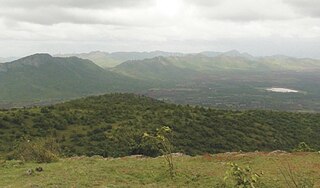
Jogimatti is a hill station]] and forest reserve in Chitradurga district, Karnataka, India. The reserve covers 10,048.97 hectares (38.7993 sq mi) in Chitradurga, Holalkere and Hiriyur taluks, 10 kilometres (6.2 mi) south of the city of Chitradurga. There is a century-old hilltop bungalow built by the British to house travellers, and a nearby temple dedicated to the local saint for whom the hill station was named, with 155 steps. The reserve has a small zoo called Adumalleshwar, which the Central Zoo Authority of India ordered renovated in 2012 to better house the animals, and an ecotourism adventure centre which opened in 2010. A waterfall called Himavatkedara or Himavatkedra has created a natural cave in which a Shiva lingam and idols of Veerabhadra and Basavanna have been placed.
Ganjigatte is a village in Holalkere tehsil, Chitradurga district of the Indian state of Karnataka.


