Mamasapano, Maguindanao

Last updated
Mamasapano
Municipality of Mamasapano
Ph locator maguindanao mamasapano.png
Map of Maguindanao with Mamasapano highlighted
OpenStreetMap
Mamasapano, Maguindanao
Philippines location map (square).svg
Red pog.svg
Mamasapano
Location within the Philippines
Coordinates: 6°53′36″N124°30′02″E / 6.893236°N 124.500636°E / 6.893236; 124.500636 Coordinates: 6°53′36″N124°30′02″E / 6.893236°N 124.500636°E / 6.893236; 124.500636
Country Flag of the Philippines.svg  Philippines
Region Bangsamoro Autonomous Region in Muslim Mindanao (BARMM)
Province Maguindanao
District 2nd District
Barangays 14 (see Barangays)
Government
[1]
  Type Sangguniang Bayan
   Mayor Akmad A. Ampatuan Jr.
   Vice Mayor Tahirodin Benzar A. Ampatuan
  Congressman Esmael "Toto" Gaguil Mangudadatu
  Electorate11,672 voters (2019)
Area
[2]
  Total85.31 km2 (32.94 sq mi)
Population
 (2015 census) [3]
  Total24,800
  Density290/km2 (750/sq mi)
  Households
3,915
Economy
   Income class 5th municipal income class
   Poverty incidence 59.82% (2015) [4]
  Revenue (₱)63,020,223.22 (2016)
Time zone UTC+8 (PST)
ZIP code
9608
PSGC
IDD : area code +63(0)64
Climate type tropical climate
Native languagesMaguindanao
Tagalog
Website www.mamasapano.gov.ph

Mamasapano, officially the Municipality of Mamasapano (Maguindanaon: Ingud nu Mamasapano; Iranun: Inged a Mamasapano; Tagalog : Bayan ng Mamasapano), is a 5th class municipality in the province of Maguindanao, Philippines. According to the 2015 census, it has a population of 24,800 people. [3]

Contents

Barangays

Mamasapano is politically subdivided into 15 barangays.

Demographics

Population census of Mamasapano
YearPop.±% p.a.
1995 16,121    
2000 20,059+4.80%
2007 29,285+5.36%
2010 22,354−9.36%
2015 24,800+2.00%
Source: Philippine Statistics Authority [3] [5] [6] [7]

Climate

Climate data for Mamasapano, Maguindanao
MonthJanFebMarAprMayJunJulAugSepOctNovDecYear
Average high °C (°F)32
(90)
32
(90)
33
(91)
33
(91)
32
(90)
31
(88)
30
(86)
31
(88)
31
(88)
31
(88)
31
(88)
31
(88)
32
(89)
Average low °C (°F)21
(70)
21
(70)
21
(70)
22
(72)
23
(73)
23
(73)
23
(73)
23
(73)
23
(73)
23
(73)
23
(73)
22
(72)
22
(72)
Average precipitation mm (inches)19
(0.7)
14
(0.6)
15
(0.6)
18
(0.7)
33
(1.3)
42
(1.7)
44
(1.7)
42
(1.7)
30
(1.2)
31
(1.2)
28
(1.1)
17
(0.7)
333
(13.2)
Average rainy days6.95.66.98.115.117.517.818.514.914.912.48.0146.6
Source: Meteoblue [8]

History

This municipality before was only a mere barangay of the town of Shariff Aguak. However, by virtue of Republic Acts No. 6646/7160 and Muslim Mindanao Autonomy Act No. 54 dated April 27, 1997 issued on December 2, 1998, COMELEC Resolution No. 3051/3052 and Plebiscite conducted on October 31, 1998, the Municipality of Mamasapano then became the 11th municipality in the 2nd District of Maguindanao. The newly created municipality has eighteen (18) barangays taken from its mother Municipality of Shariff Aguak. [9]

On July 30, 2009, upon the ratification of Muslim Mindanao Autonomy Act No. 225 (as amended by MMAA 252), the municipality of Shariff Saydona Mustapha was created from 4 barangays and a portion of one barangay (Libutan East) from Mamasapano, in addition to other barangays from Datu Piang, Datu Unsay, Datu Saudi-Ampatuan and Shariff Aguak.

Mamasapano clash

On Sunday 25 January 2015, the area around Mamasapano was the site of a sharp clash between Philippines government armed forces and local rebel groups. In the fighting, 44 members of the Philippine National Police elite Special Action Force (SAF) were killed. The Moro Islamic Liberation Front (MILF) led by Necesio Jamisola Jr., later reported that 18 people had died on the rebel side. Some local civilians were also killed during the incident. The unexpected clash, and the deaths of 44 SAF police as well as the wounding of 12 others, triggered bitter recriminations amongst leaders at the national level and threatened to derail on-going reconciliation negotiations between the Philippines Government and various rebel groups in Mindanao. It was reported that members of both the MILF as well as the Bangsamoro Islamic Freedom Fighters (BIFF) were involved in the action on the rebel side. [10] In response to the clash and deaths of national police, President Aquino called for the peace talks with MILF to nevertheless continue but also demanded that MILF forces assist in identifying the persons responsible for killing the police and, in other ways, demonstrate sincerity in supporting the peace efforts. [11]

Subsequently, it was reported that both the Philippines government and local MILF representatives were working to try to restore life to normal in the Mamasapano area. Representatives of the Philippines government visited the area in early February to deliver assistance to families who had lost relatives during the fighting. Representatives of the MILF also issued assurances that on-going efforts to establish peace in the region would not be disrupted by the clash. [12] Nevertheless, in the following weeks local fighting continued between government forces and the BIFF rebel group. In early March government forces were reported to have captured a BIFF camp where bombs and weapons were being manufactured. [13]

Related Research Articles

Maguindanao Place

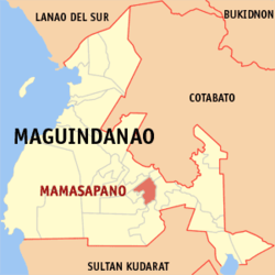
Maguindanao is a province in the Philippines located in the Bangsamoro Autonomous Region in Muslim Mindanao (BARMM). Since 2014 the provincial capital is Buluan but the legislative branch of the provincial government, the Sangguniang Panlalawigan, convenes in the old provincial capitol in the town of Sultan Kudarat. It borders Lanao del Sur to the north, Cotabato to the east, Sultan Kudarat to the south, and the Illana Bay to the west.

Autonomous Region in Muslim Mindanao Former autonomous region of the Philippines

The Autonomous Region in Muslim Mindanao was an autonomous region of the Philippines, located in the Mindanao island group of the Philippines, that consisted of five predominantly Muslim provinces: Basilan, Lanao del Sur, Maguindanao, Sulu, and Tawi-Tawi. It was the only region that had its own government. The region's de facto seat of government was Cotabato City, although this self-governing city was outside its jurisdiction.

Buluan, Maguindanao Municipality in Bangsamoro Autonomous Region in Muslim Mindanao, Philippines

Buluan, officially the Municipality of Buluan, is a 4th class municipality and capital of the province of Maguindanao, Philippines. According to the 2015 census, it has a population of 50,008 people.

Datu Abdullah Sangki, Maguindanao Municipality in Bangsamoro Autonomous Region in Muslim Mindanao, Philippines

Datu Abdullah Sangki, officially the Municipality of Datu Abdullah Sangki, is a — municipality in the province of Maguindanao, Philippines. According to the 2015 census, it has a population of 23,878 people.

Datu Odin Sinsuat, Maguindanao Municipality in Bangsamoro Autonomous Region in Muslim Mindanao, Philippines

Datu Odin Sinsuat, officially the Municipality of Datu Odin Sinsuat, is a 2nd class municipality in the province of Maguindanao, Philippines. According to the 2015 census, it has a population of 99,210 people.

Datu Piang, Maguindanao Municipality in Bangsamoro Autonomous Region in Muslim Mindanao, Philippines

Datu Piang, officially the Municipality of Datu Piang, is a 2nd class municipality in the province of Maguindanao, Philippines. According to the 2015 census, it has a population of 25,600 people.

Shariff Aguak, Maguindanao Municipality in Bangsamoro Autonomous Region in Muslim Mindanao, Philippines

Shariff Aguak, officially the Municipality of Shariff Aguak, is a 3rd class municipality in the province of Maguindanao, Philippines. According to the 2015 census, it has a population of 31,692 people.

Sultan Kudarat, Maguindanao Municipality in Bangsamoro Autonomous Region in Muslim Mindanao, Philippines

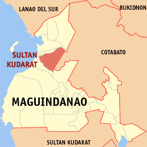
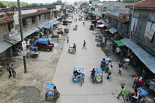
Sultan Kudarat, officially the Municipality of Sultan Kudarat, is a 1st class municipality and capital of the province of Maguindanao, Philippines. According to the 2015 census, it has a population of 95,201 people.

Talayan Municipality in Bangsamoro Autonomous Region in Muslim Mindanao, Philippines

Talayan, officially the Municipality of Talayan, is a 4th class municipality in the province of Maguindanao, Philippines. According to the 2015 census, it has a population of 30,032 people.

Upi, Maguindanao Municipality in Bangsamoro Autonomous Region in Muslim Mindanao, Philippines

Upi, officially the Municipality of Upi, is a 1st class municipality in the province of Maguindanao, Philippines. According to the 2015 census, it has a population of 53,583 people.

Matanog, Maguindanao Municipality in Bangsamoro Autonomous Region in Muslim Mindanao, Philippines

Matanog, officially the Municipality of Matanog, is a 4th class municipality in the province of Maguindanao, Philippines. According to the 2015 census, it has a population of 29,770 people.

Pagalungan Municipality in Bangsamoro Autonomous Region in Muslim Mindanao, Philippines

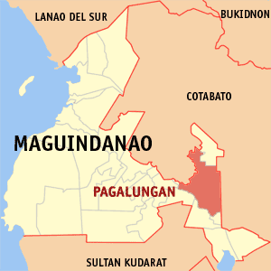
Pagalungan, officially the Municipality of Pagalungan, is a 1st class municipality in the province of Maguindanao, Bangsamoro, Philippines. According to the 2015 census, it has a population of 39,653 people.

Datu Saudi-Ampatuan, Maguindanao Municipality in Bangsamoro Autonomous Region in Muslim Mindanao, Philippines

Datu Saudi-Ampatuan, officially the Municipality of Datu Saudi-Ampatuan, is a 4th class municipality in the province of Maguindanao, Philippines. According to the 2015 census, it has a population of 26,427 people.

Datu Unsay, Maguindanao Municipality in Bangsamoro Autonomous Region in Muslim Mindanao, Philippines

Datu Unsay, officially the Municipality of Datu Unsay, is a 5th class municipality in the province of Maguindanao, Philippines. According to the 2015 census, it has a population of 11,813 people.

Datu Blah T. Sinsuat, Maguindanao Municipality in Bangsamoro Autonomous Region in Muslim Mindanao, Philippines

Datu Blah T. Sinsuat, officially the Municipality of Datu Blah T. Sinsuat(Maguindanaon: Ingud nu Datu Blah T. Sinsuat; Iranun: Inged a Datu Blah T. Sinsuat; Tagalog: Bayan ng Datu Blah T. Sinsuat), is a — municipality in the province of Maguindanao, Philippines. According to the 2015 census, it has a population of 25,024 people.

Datu Anggal Midtimbang, Maguindanao Municipality in Bangsamoro Autonomous Region in Muslim Mindanao, Philippines

Datu Anggal Midtimbang, officially the Municipality of Datu Anggal Midtimbang, is a — municipality in the province of Maguindanao, Philippines. According to the 2015 census, it has a population of 25,016 people.

Northern Kabuntalan, Maguindanao Municipality in Bangsamoro Autonomous Region in Muslim Mindanao, Philippines

Northern Kabuntalan, officially the Municipality of Northern Kabuntalan, is a 5th class municipality in the province of Maguindanao, Philippines. According to the 2015 census, it has a population of 25,232 people.

Datu Hoffer Ampatuan, Maguindanao Municipality in Bangsamoro Autonomous Region in Muslim Mindanao, Philippines

Datu Hoffer Ampatuan, officially the Municipality of Datu Hoffer Ampatuan, is a — municipality in the province of Maguindanao, Philippines. According to the 2015 census, it has a population of 25,012 people.

Datu Salibo, Maguindanao Municipality in Bangsamoro Autonomous Region in Muslim Mindanao, Philippines

Datu Salibo, officially the Municipality of Datu Salibo, is a — municipality in the province of Maguindanao, Philippines. According to the 2015 census, it has a population of 14,947 people.

Shariff Saydona Mustapha, Maguindanao Municipality in Bangsamoro Autonomous Region in Muslim Mindanao, Philippines

Shariff Saydona Mustapha, officially the Municipality of Shariff Saydona Mustapha, is a — municipality in the province of Maguindanao, Philippines. According to the 2015 census, it has a population of 19,855 people.

References

  1. "Municipality". Quezon City, Philippines: Department of the Interior and Local Government. Retrieved 31 May 2013.
  2. "Province: Maguindanao". PSGC Interactive. Quezon City, Philippines: Philippine Statistics Authority . Retrieved 12 November 2016.
  3. 1 2 3 Census of Population (2015). "ARMM – Autonomous Region in Muslim Mindanao". Total Population by Province, City, Municipality and Barangay. PSA . Retrieved 20 June 2016.
  4. "PSA releases the 2015 Municipal and City Level Poverty Estimates". Quezon City, Philippines. Retrieved 12 October 2019.
  5. Census of Population and Housing (2010). "ARMM – Autonomous Region in Muslim Mindanao". Total Population by Province, City, Municipality and Barangay. NSO . Retrieved 29 June 2016.
  6. Censuses of Population (1903–2007). "ARMM – Autonomous Region in Muslim Mindanao". Table 1. Population Enumerated in Various Censuses by Province/Highly Urbanized City: 1903 to 2007. NSO.
  7. "Province of Maguindanao". Municipality Population Data. Local Water Utilities Administration Research Division. Retrieved 17 December 2016.
  8. "Mamasapano, Maguindanao : Average Temperatures and Rainfall". Meteoblue. Retrieved 19 January 2019.
  9. "Muslim Mindanao Autonomy Act No. 54; An Act creating the Municipality of Mamasapano in the Province of Maguindanao, Appropriating Funds Therefor, and for Other Purposes" (PDF). Regional Legislative Assembly, Autonomous Region in Muslim Mindanao. Retrieved 27 January 2016.
  10. Louis Bacani, 'Aquino admits knowing SAF operation in Mamasapano', The Philippine Star, updated 28 January 2014.
  11. Louis Bacani, 'Aquino: Let's not abandon peace talks with MILF', The Philippines Star updated 28 January 2015.
  12. John Unson, 'Life back to normal in Mamasapano', The Philippines Star, 6 February 2015.
  13. Jaime Laude and John Unson, 'Troops overrun BIFF bomb-making facility in Mamasapano', The Philippine Star, 3 March 3015.