Upi, Maguindanao

Last updated
Upi
Municipality of Upi
The Municipal Hall of Upi.jpg
Municipal Hall of Upi
Flag of Upi, Maguindanao.png
Upi logo.png
Ph locator maguindanao upi.png
Map of Maguindanao with Upi highlighted
OpenStreetMap
Upi, Maguindanao
Philippines location map (square).svg
Red pog.svg
Upi
Location within the Philippines
Coordinates: 7°01′44″N124°09′54″E / 7.0289°N 124.165°E / 7.0289; 124.165 Coordinates: 7°01′44″N124°09′54″E / 7.0289°N 124.165°E / 7.0289; 124.165
Country Philippines
Region Bangsamoro Autonomous Region in Muslim Mindanao
Province Maguindanao
District 1st district
Founded June 10, 1955
Barangays 23 (see Barangays)
Government
[1]
  Type Sangguniang Bayan
   Mayor Ma. Rona Cristina P. Flores
   Vice Mayor Wilfredo T. Ibañez
   Representative Sittie Shahara "Dimple" I. Mastura (PDPLBN)
   Municipal Council
Members
   Electorate 38,108 voters (2019)
Area
[2]
  Total742.95 km2 (286.85 sq mi)
Elevation
537 m (1,762 ft)
Highest elevation
1,002 m (3,287 ft)
Lowest elevation
367 m (1,204 ft)
Population
 (2020 census) [3]
  Total59,004
  Density79/km2 (210/sq mi)
   Households
11,596
Economy
   Income class 1st municipal income class
   Poverty incidence 50.95% (2018) [4]
   Revenue ₱322,301,000.00 (2020)
   Assets ₱371,540,000.00 (2020)
   Expenditure ₱290,537,000.00 (2020)
   Liabilities ₱15,231,000.00 (2020)
Service provider
  ElectricityMaguindanao Electric Cooperative (MAGELCO)
Time zone UTC+8 (PST)
ZIP code
9602
PSGC
IDD : area code +63(0)64
Native languages Maguindanao
Tiruray
Tagalog
Website www.upi.gov.ph

Upi, officially the Municipality of Upi (Maguindanaon: Inged nu Upi; Iranun: Inged a Upi; Tagalog : Bayan ng Upi), is a 1st class municipality in the province of Maguindanao, Philippines. According to the 2020 census, it has a population of 59,004 people. [3]

Contents

The municipality was part of the province of Shariff Kabunsuan from October 2006 until its nullification by the Supreme Court in July 2008.

Etymology

The name Upi probably derives from the term ufi. Ufi is a Teduray name for a certain tree (piper betel) that grew abundantly in the place in the early years. The bark of the ufi is used with betel nuts for chewing or mama in Teduray. The Teduray are the native inhabitants of present-day Upi.

History

The beginning of Upi as a district geographical and political entity largely began from the early part of 1901 to 1910, when American forces set foot in the then Province of Cotabato.

An American Army Officer, Captain Irving Bryant Edwards, was assigned in Awang. Edwards showed great interest in bringing the government closer to the people by establishing schools in the far-flung areas. He reached the fertile valley of Upi and founded the Upi Agricultural School on August 19, 1919. From a USAFFE soldier, Capt. Irving Bryant Edwards turned educator.

Upi was formerly a barrio of Dinaig. It was separated from Dinaig by virtue of Republic Act No. 1248, which was approved on June 10, 1955. [5] On December 16 of the same year, President Elpidio Quirino signed Executive Order No. 142, creating 42 barrios of Upi. [6]

The first municipal mayor, vice mayor and councilors of Upi were appointed by the president of the Philippines. Maria Badoy was appointed as the first municipal mayor. In 1956, residents of the town were encouraged to participate in the political affairs of the local government, and there took place the first election wherein Mayor Ignacio Tenorio Labina, a Teduray leader, was the first elected mayor of Upi and held his office for four years.

In 2006, Upi lost about 147 square kilometres (57 sq mi) when the coastal barangays Kinimi, Laguitan, Lapaken, Matuber, Meti, Nalkan, Penansaran, Sedem, Sinipak, Resa, Tambak and Tubuan were separated from the municipality to create the new municipality of Datu Blah T. Sinsuat. [7]

Geography

Upi is a mountainous town situated in the south-western coastal portion of Maguindanao province.

Barangays

Upi is politically subdivided into 23 barangays.

  • Bantek
  • Bayabas
  • Blensong
  • Borongotan
  • Bugabungan
  • Bungcog
  • Darugao
  • Ganasi
  • Kabakaba
  • Kibleg
  • Kibucay
  • Kiga
  • Kinitaan
  • Mirab
  • Nangi
  • Nuro (Poblacion)
  • Ranao Pilayan
  • Rempes
  • Renede
  • Renti
  • Rifao
  • Sefegefen
  • Tinungkaan

Climate

Climate data for Upi, Maguindanao
MonthJanFebMarAprMayJunJulAugSepOctNovDecYear
Average high °C (°F)29
(84)
29
(84)
29
(84)
29
(84)
28
(82)
27
(81)
26
(79)
27
(81)
27
(81)
27
(81)
27
(81)
28
(82)
28
(82)
Average low °C (°F)18
(64)
19
(66)
19
(66)
20
(68)
21
(70)
21
(70)
20
(68)
20
(68)
20
(68)
20
(68)
20
(68)
19
(66)
20
(68)
Average precipitation mm (inches)30
(1.2)
19
(0.7)
25
(1.0)
24
(0.9)
64
(2.5)
88
(3.5)
102
(4.0)
105
(4.1)
76
(3.0)
82
(3.2)
60
(2.4)
26
(1.0)
701
(27.5)
Average rainy days9.88.511.311.921.623.924.124.520.921.816.811.8206.9
Source: Meteoblue (modeled/calculated data, not measured locally) [8]

Demographics

Population census of Upi
YearPop.±% p.a.
1960 27,616    
1970 35,727+2.61%
1975 39,010+1.78%
1980 31,010−4.48%
1990 45,957+4.01%
1995 46,440+0.20%
2000 51,141+2.09%
2007 41,757−2.76%
2010 45,444+3.13%
2015 53,583+3.19%
2020 59,004+1.91%
Source: Philippine Statistics Authority [9] [10] [11] [12]

Economy

Government

The current mayor of Upi is Ramon A. Piang Sr., a former principal of Notre Dame of Upi, a local high school managed by the Archdiocesan Notre Dame Schools of Cotabato.

List of former mayors:

Culture

Meguyaya festival

Meguyaya, a Teduray term for thanksgiving for the bountiful harvest, is an annual festival celebrated every December. The festivities incorporate street dancing competition depicting the tri-people culture of the Teduray, Maguindanaon and Settlers. Other activities include the Cultural Nights, Local Government Unit Night, Ginoong Meguyaya male pageant, trade fair and Maisan Na. This is an activity in which a long stretch of grillers are placed by the roadside where everyone enjoys roasting corns, a symbol of togetherness and feasting.[ citation needed ]

Related Research Articles

<span class="mw-page-title-main">Maguindanao</span> Filipino province (1973–2022)

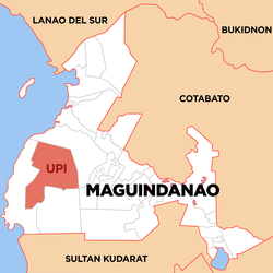
Maguindanao was a province in the Philippines located in the Bangsamoro Autonomous Region in Muslim Mindanao (BARMM). Since 2014 the provincial capital is Buluan but the legislative branch of the provincial government, the Sangguniang Panlalawigan, convenes in the old provincial capitol in the town of Sultan Kudarat. It borders Lanao del Sur to the north, Cotabato to the east, Sultan Kudarat to the south, and the Illana Bay to the west.

<span class="mw-page-title-main">Cotabato City</span> Independent component city in Bangsamoro, Philippines

Cotabato City, officially known as the City of Cotabato, is a 3rd class independent component city in the Bangsamoro Autonomous Region in Muslim Mindanao, Philippines. According to the 2020 census, it has a population of 325,079 people,  making it as the most populated city under the independent component city status.

<span class="mw-page-title-main">Ampatuan, Maguindanao</span> Municipality in Bangsamoro Autonomous Region in Muslim Mindanao, Philippines

Ampatuan, officially the Municipality of Ampatuan, is a 4th class municipality in the province of Maguindanao del Sur, Philippines. According to the 2020 census, it has a population of 28,941 people. 

<span class="mw-page-title-main">Datu Odin Sinsuat</span> Municipality in Bangsamoro Autonomous Region in Muslim Mindanao, Philippines

Datu Odin Sinsuat, officially the Municipality of Datu Odin Sinsuat, is a 2nd class municipality and capital of the province of Maguindanao del Norte, Philippines. According to the 2020 census, it has a population of 116,768 people. 

<span class="mw-page-title-main">Datu Piang, Maguindanao</span> Municipality in Bangsamoro Autonomous Region in Muslim Mindanao, Philippines

Datu Piang, officially the Municipality of Datu Piang, is a 2nd class municipality in the province of Maguindanao, Philippines. According to the 2020 census, it has a population of 28,380 people. 

<span class="mw-page-title-main">Paglat</span> Municipality in Bangsamoro Autonomous Region in Muslim Mindanao, Philippines

Paglat, officially the Municipality of Paglat, is a municipality in the province of Maguindanao, Philippines. According to the 2020 census, it has a population of 18,727 people. 

<span class="mw-page-title-main">Shariff Aguak</span> Municipality in Bangsamoro Autonomous Region in Muslim Mindanao, Philippines

Shariff Aguak, officially the Municipality of Shariff Aguak, is a 3rd class municipality in the province of Maguindanao, Philippines. According to the 2020 census, it has a population of 33,982 people. 

<span class="mw-page-title-main">Sultan Kudarat, Maguindanao</span> Municipality in Bangsamoro Autonomous Region in Muslim Mindanao, Philippines

Sultan Kudarat, officially the Municipality of Sultan Kudarat, is a 1st class municipality and legislative capital of the province of Maguindanao, Philippines. According to the 2020 census, it has a population of 105,121 people. 

<span class="mw-page-title-main">Sultan sa Barongis</span> Municipality in Bangsamoro Autonomous Region in Muslim Mindanao, Philippines

Sultan sa Barongis, officially the Municipality of Sultan sa Barongis, is a 2nd class municipality in the province of Maguindanao del Sur, Philippines. According to the 2020 census, it has a population of 24,476 people. 

<span class="mw-page-title-main">Talayan</span> Municipality in Bangsamoro Autonomous Region in Muslim Mindanao, Philippines

Talayan, officially the Municipality of Talayan, is a 4th class municipality in the province of Maguindanao del Sur, Philippines. According to the 2020 census, it has a population of 34,156 people. 

<span class="mw-page-title-main">Mamasapano</span> Municipality in Bangsamoro Autonomous Region in Muslim Mindanao, Philippines

Mamasapano, officially the Municipality of Mamasapano, is a 5th class municipality in the province of Maguindanao, Philippines. According to the 2020 census, it has a population of 27,807 people. 

<span class="mw-page-title-main">Pagalungan</span> Municipality in Bangsamoro Autonomous Region in Muslim Mindanao, Philippines

Pagalungan, officially the Municipality of Pagalungan, is a 1st class municipality in the province of Maguindanao, Bangsamoro, Philippines. According to the 2020 census, it has a population of 46,277 people. 

<span class="mw-page-title-main">Datu Saudi Ampatuan</span> Municipality in Bangsamoro Autonomous Region in Muslim Mindanao, Philippines

Datu Saudi Ampatuan, officially the Municipality of Datu Saudi Ampatuan, is a 4th class municipality in the province of Maguindanao, Philippines. According to the 2020 census, it has a population of 31,060 people. 

<span class="mw-page-title-main">Datu Unsay</span> Municipality in Bangsamoro Autonomous Region in Muslim Mindanao, Philippines

Datu Unsay, officially the Municipality of Datu Unsay, is a 5th class municipality in the province of Maguindanao, Philippines. According to the 2020 census, it has a population of 12,890 people. 

<span class="mw-page-title-main">Guindulungan</span> Municipality in Bangsamoro Autonomous Region in Muslim Mindanao, Philippines

Guindulungan, officially the Municipality of Guindulungan, is a municipality in the province of Maguindanao, Philippines. According to the 2020 census, it has a population of 24,933 people. 

<span class="mw-page-title-main">Datu Blah T. Sinsuat</span> Municipality in Bangsamoro Autonomous Region in Muslim Mindanao, Philippines

Datu Blah T. Sinsuat, officially the Municipality of Datu Blah T. Sinsuat, is a municipality in the province of Maguindanao, Philippines. According to the 2020 census, it has a population of 28,243 people. 

<span class="mw-page-title-main">Datu Anggal Midtimbang</span> Municipality in Bangsamoro Autonomous Region in Muslim Mindanao, Philippines

Datu Anggal Midtimbang, officially the Municipality of Datu Anggal Midtimbang, is a municipality in the province of Maguindanao, Philippines. According to the 2020 census, it has a population of 28,224 people. 

<span class="mw-page-title-main">Datu Hoffer Ampatuan</span> Municipality in Bangsamoro Autonomous Region in Muslim Mindanao, Philippines

Datu Hoffer Ampatuan, officially the Municipality of Datu Hoffer Ampatuan, is a municipality in the province of Maguindanao, Philippines. According to the 2020 census, it has a population of 26,660 people. 

Datu Salibo, officially the Municipality of Datu Salibo, is a municipality in the province of Maguindanao, Philippines. According to the 2020 census, it has a population of 18,795 people. 

<span class="mw-page-title-main">Shariff Saydona Mustapha</span> Municipality in Bangsamoro Autonomous Region in Muslim Mindanao, Philippines

Shariff Saydona Mustapha, officially the Municipality of Shariff Saydona Mustapha, is a municipality in the province of Maguindanao, Philippines. According to the 2020 census, it has a population of 25,080 people. 

References

  1. Municipality of Upi | (DILG)
  2. "2015 Census of Population, Report No. 3 – Population, Land Area, and Population Density" (PDF). Philippine Statistics Authority. Quezon City, Philippines. August 2016. ISSN   0117-1453. Archived (PDF) from the original on May 25, 2021. Retrieved July 16, 2021.
  3. 1 2 Census of Population (2020). "BARMM". Total Population by Province, City, Municipality and Barangay. PSA . Retrieved 8 July 2021.
  4. "PSA Releases the 2018 Municipal and City Level Poverty Estimates". Philippine Statistics Authority. 15 December 2021. Retrieved 22 January 2022.
  5. "An Act to Create the Municipality of Upi in the Province of Cotabato". LawPH.com. Retrieved 2011-04-11.
  6. "Executive Order No. 142, s. 1955 | GOVPH".
  7. "Muslim Mindanao Autonomy Act No.198: An Act Creating The Municipality of Datu Blah T. Sinsuat in The Province of Maguindanao, Providing Funds Therfor, and for Other Purposes" (PDF). lawphil.net. Cotabato City: Arellano Law Foundation. 2006. Retrieved 28 July 2020.
  8. "Upi, Maguindanao : Average Temperatures and Rainfall". Meteoblue. Retrieved 19 January 2019.
  9. Census of Population (2015). "ARMM – Autonomous Region in Muslim Mindanao". Total Population by Province, City, Municipality and Barangay. PSA . Retrieved 20 June 2016.
  10. Census of Population and Housing (2010). "ARMM – Autonomous Region in Muslim Mindanao". Total Population by Province, City, Municipality and Barangay. NSO . Retrieved 29 June 2016.
  11. Censuses of Population (1903–2007). "ARMM – Autonomous Region in Muslim Mindanao". Table 1. Population Enumerated in Various Censuses by Province/Highly Urbanized City: 1903 to 2007. NSO.
  12. "Province of Maguindanao". Municipality Population Data. Local Water Utilities Administration Research Division. Retrieved 17 December 2016.
  13. "Poverty incidence (PI):". Philippine Statistics Authority. Retrieved 28 December 2020.
  14. https://psa.gov.ph/sites/default/files/NSCB_LocalPovertyPhilippines_0.pdf; publication date: 29 November 2005; publisher: Philippine Statistics Authority.
  15. https://psa.gov.ph/sites/default/files/2003%20SAE%20of%20poverty%20%28Full%20Report%29_1.pdf; publication date: 23 March 2009; publisher: Philippine Statistics Authority.
  16. https://psa.gov.ph/sites/default/files/2006%20and%202009%20City%20and%20Municipal%20Level%20Poverty%20Estimates_0_1.pdf; publication date: 3 August 2012; publisher: Philippine Statistics Authority.
  17. https://psa.gov.ph/sites/default/files/2012%20Municipal%20and%20City%20Level%20Poverty%20Estima7tes%20Publication%20%281%29.pdf; publication date: 31 May 2016; publisher: Philippine Statistics Authority.
  18. https://psa.gov.ph/sites/default/files/City%20and%20Municipal-level%20Small%20Area%20Poverty%20Estimates_%202009%2C%202012%20and%202015_0.xlsx; publication date: 10 July 2019; publisher: Philippine Statistics Authority.
  19. "PSA Releases the 2018 Municipal and City Level Poverty Estimates". Philippine Statistics Authority. 15 December 2021. Retrieved 22 January 2022.