
Escurial is a municipality located in the province of Cáceres, Extremadura, Spain.
The Province of Vaasa was a province of Finland, established in 1775 when Finland was an integrated part of Sweden from the southern part of Ostrobothnia County and disbanded in 1996. The province was named after the city of Vaasa.

The Battle of Kizil-tepe was fought on August 25, 1877, between the Russian Empire and the Ottoman Empire. The Russian were attempting to besiege Kars. The Ottomans, vastly superior in numbers, successfully lifted the siege.
Upper Lillooet Provincial Park is a provincial park in British Columbia, Canada. The 19,996-hectare park was established on July 28, 1997, under the National Parks Act.

Tekkali is a census town in Srikakulam district of the Indian state of Andhra Pradesh. It is the mandal headquarters of Tekkali mandal and Tekkali revenue division and is located at a distance of 51 km from the district headquarters.
Man Pakadi is a village development committee in Rupandehi District in Lumbini Province of southern Nepal. At the time of the 1991 Nepal census it had a population of 4839 people living in 741 individual households.
Mindourou is a town and commune in Cameroon.
Tlaxco Municipality is a municipality in the Mexican state of Puebla in southeastern Mexico.
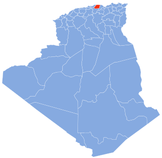
Bouzeguène District is a district of Tizi Ouzou Province, Algeria.

Ryazan Governorate was an administrative-territorial unit (guberniya) of the Russian Empire and the Russian SFSR, which existed from 1796 to 1929. Its capital was in Ryazan.
Pee Pee Creek is a stream in Pike County, Ohio, in the United States.

Ushachy is an urban-type settlement in Vitebsk Region, Belarus. It serves as the administrative center of Ushachy District. The settlement is located 101 kilometres (63 mi) west of Vitebsk. As of 2023, it has a population of 5,802.
Kamenartsi is a village in Kardzhali Municipality, Kardzhali Province, southern Bulgaria.
Konevo is a village in Kardzhali Municipality, Kardzhali Province, southern Bulgaria.

Kyosevo is a village in Kardzhali Municipality, Kardzhali Province, southern Bulgaria.
Miladinovo is a village in Kardzhali Municipality, Kardzhali Province, southern Bulgaria.
Rezbartsi is a village in Kardzhali Municipality, Kardzhali Province, southern Bulgaria.
Vishegrad is a village in Kardzhali Municipality, Kardzhali Province, southern Bulgaria.
Zhitarnik is a village in Kardzhali Municipality, Kardzhali Province, southern Bulgaria.
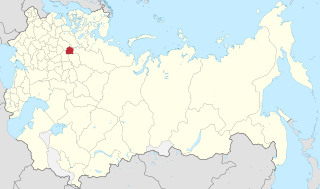
Yaroslavl Governorate was an administrative-territorial unit (guberniya) of the Russian Empire and the Russian SFSR, located in European Russia in the Upper Volga Region. It existed from 1777 to 1929; its seat was in the city of Yaroslavl.


