Mammoth Hot Springs

Last updated
Mammoth Hot Springs
Dead trees at Mammoth Hot Springs.jpg
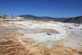
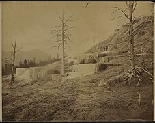
Dead Trees at Mammoth Hot Springs
Mammoth Hot Springs
LocationMammoth Hot Springs, Yellowstone National Park, Park County, Wyoming
Coordinates 44°58′01″N110°42′44″W / 44.96694°N 110.71222°W / 44.96694; -110.71222 [1]
Elevation6,735 feet (2,053 m) [2]
Type Hot spring complex

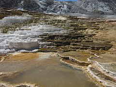
Mammoth Hot Springs is a large complex of hot springs on a hill of travertine in Yellowstone National Park adjacent to Fort Yellowstone and the Mammoth Hot Springs Historic District. [3] It was created over thousands of years as hot water from the spring cooled and deposited calcium carbonate (over two tons flow into Mammoth each day in a solution). Because of the huge amount of geothermal vents, travertine flourishes. [4] Although these springs lie outside the caldera boundary, their energy has been attributed to the same magmatic system that fuels other Yellowstone geothermal areas.

Contents

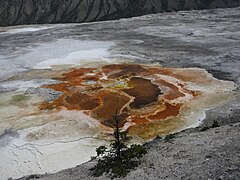
The hot water that feeds Mammoth comes from Norris Geyser Basin after traveling underground via a fault line [5] that runs through limestone and roughly parallel to the Norris-to-Mammoth road. The limestone from rock formations along the fault is the source of the calcium carbonate. [6] [7] Shallow circulation along this corridor allows Norris's superheated water to slightly cool before surfacing at Mammoth, generally at about 170 °F (80 °C). Algae living in the warm pools have tinted the travertine shades of brown, orange, red, and green. [8]

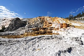
Thermal activity here is extensive both over time and distance. The thermal flows show much variability with some variations taking place over periods ranging from decades to days. [6] Terrace Mountain at Mammoth Hot Springs is the largest known carbonate-depositing spring in the world. The most famous feature at the springs is the Minerva Terrace, a series of travertine terraces. The terraces have been deposited by the spring over many years but, due to recent minor earthquake activity,[ when? ] the spring vent has shifted, rendering the terraces dry.

The Mammoth Terraces extend all the way from the hillside, across the Parade Ground, and down to Boiling River. The Mammoth Hotel, as well as all of Fort Yellowstone, is built upon an old terrace formation known as Hotel Terrace. There was some concern when construction began in 1891 on the fort site that the hollow ground would not support the weight of the buildings. Several large sink holes (fenced off) can be seen out on the Parade Ground. This area has been thermally active for several thousand years. [9]

The Mammoth area exhibits much evidence of glacial activity from the Pinedale Glaciation. The summit of Terrace Mountain is covered with glacial till, thereby dating the travertine formation there to earlier than the end of the Pinedale Glaciation. Several thermal kames, including Capitol Hill and Dude Hill, are major features of the Mammoth Village area. Ice-marginal stream beds are in evidence in the small, narrow valleys where Floating Island Lake and Phantom Lake are found. In Gardner Canyon one can see the old, sorted gravel bed of the Gardner River covered by unsorted glacial till. [9]

Individually named thermal features

See also

Related Research Articles

<span class="mw-page-title-main">Long Valley Caldera</span> Geologic depression near Mammoth Mountain, California, United States

Long Valley Caldera is a depression in eastern California that is adjacent to Mammoth Mountain. The valley is one of the Earth's largest calderas, measuring about 20 mi (32 km) long (east-west), 11 mi (18 km) wide (north-south), and up to 3,000 ft (910 m) deep.

<span class="mw-page-title-main">Geothermal areas of Yellowstone</span> Geyser basins and other geothermal features in Yellowstone National Park

The geothermal areas of Yellowstone include several geyser basins in Yellowstone National Park as well as other geothermal features such as hot springs, mud pots, and fumaroles. The number of thermal features in Yellowstone is estimated at 10,000. A study that was completed in 2011 found that a total of 1,283 geysers have erupted in Yellowstone, 465 of which are active during an average year. These are distributed among nine geyser basins, with a few geysers found in smaller thermal areas throughout the Park. The number of geysers in each geyser basin are as follows: Upper Geyser Basin (410), Midway Geyser Basin (59), Lower Geyser Basin (283), Norris Geyser Basin (193), West Thumb Geyser Basin (84), Gibbon Geyser Basin (24), Lone Star Geyser Basin (21), Shoshone Geyser Basin (107), Heart Lake Geyser Basin (69), other areas (33). Although famous large geysers like Old Faithful are part of the total, most of Yellowstone's geysers are small, erupting to only a foot or two. The hydrothermal system that supplies the geysers with hot water sits within an ancient active caldera. Many of the thermal features in Yellowstone build up sinter, geyserite, or travertine deposits around and within them.

<span class="mw-page-title-main">Travertine</span> Form of limestone deposited by mineral springs

Travertine is a form of terrestrial limestone deposited around mineral springs, especially hot springs. It often has a fibrous or concentric appearance and exists in white, tan, cream-colored, and rusty varieties. It is formed by a process of rapid precipitation of calcium carbonate, often at the mouth of a hot spring or in a limestone cave. In the latter, it can form stalactites, stalagmites, and other speleothems. It is frequently used in Italy and elsewhere as a building material. Similar deposits formed from ambient-temperature water are known as tufa.

<span class="mw-page-title-main">Tufa</span> Porous limestone rock formed when carbonate minerals precipitate out of ambient temperature water

Tufa is a variety of limestone formed when carbonate minerals precipitate out of water in unheated rivers or lakes. Geothermally heated hot springs sometimes produce similar carbonate deposits, which are known as travertine. Tufa is sometimes referred to as (meteogene) travertine. It should not be confused with hot spring (thermogene) travertine. Tufa, which is calcareous, should also not be confused with tuff, a porous volcanic rock with a similar etymology that is sometimes also called "tufa".

<span class="mw-page-title-main">Pamukkale</span> Natural site in Denizli Province in southwestern Turkey

Pamukkale, meaning "cotton castle" in Turkish, is a natural site in Denizli Province in southwestern Turkey. The area is famous for a carbonate mineral left by the flowing of thermal spring water. It is located in Turkey's Inner Aegean region, in the River Menderes valley, which has a temperate climate for most of the year.

<span class="mw-page-title-main">Mineral spring</span> Natural springs that produce water containing minerals

Mineral springs are naturally occurring springs that produce hard water, water that contains dissolved minerals. Salts, sulfur compounds, and gases are among the substances that can be dissolved in the spring water during its passage underground. In this they are unlike sweet springs, which produce soft water with no noticeable dissolved gasses. The dissolved minerals may alter the water's taste. Mineral water obtained from mineral springs, and the precipitated salts such as Epsom salt have long been important commercial products.

<span class="mw-page-title-main">Grand Prismatic Spring</span> Largest hot spring in the United States

The Grand Prismatic Spring in Yellowstone National Park is the largest hot spring in the United States, and the third largest in the world, after Frying Pan Lake in New Zealand and Boiling Lake in Dominica. It is located in the Midway Geyser Basin.

<span class="mw-page-title-main">Fishing Cone</span> Geyser in Yellowstone National Park

Fishing Cone, also known as Fishing Pot Hot Springs is a geyser in the West Thumb Geyser Basin of Yellowstone National Park in Wyoming - America.

<span class="mw-page-title-main">Black Pool</span> Hot spring in Yellowstone park, United States

Black Pool is a hot spring in the West Thumb Geyser Basin of Yellowstone National Park in the United States.

<span class="mw-page-title-main">Trails of Yellowstone National Park</span>

Yellowstone National Park has over 1,100 miles (1,800 km) of blazed and mapped hiking trails, including some that have been in use for hundreds of years. Several of these trails were the sites of historical events. Yellowstone's trails are noted for various geysers, hot springs, and other geothermal features, and for viewing of bald eagles, ospreys, grizzly bears, black bears, wolves, coyotes, bighorn sheep, pronghorns, and free-ranging herds of bison and elk.

<span class="mw-page-title-main">Mammoth Hot Springs Historic District</span> United States historic place in Yellowstone National Park

The Mammoth Hot Springs Historic District is a 158-acre (64 ha) historic district in Yellowstone National Park comprising the administrative center for the park. It is composed of two major parts: Fort Yellowstone, the military administrative center between 1886 and 1918, and now a National Historic Landmark, and a concessions district which provides food, shopping, services, and lodging for park visitors and employees. It was added to the National Register of Historic Places on March 20, 2002, for its significance in architecture, conservation, entertainment/recreation, and military. The district includes 189 contributing buildings.

<span class="mw-page-title-main">Outline of Yellowstone National Park</span>

The following articles relate to the history, geography, geology, flora, fauna, structures and recreation in Yellowstone National Park.

<span class="mw-page-title-main">Mount Everts</span> Mountain in Montana, United States

Mount Everts, elevation 7,846 feet (2,391 m), is a prominent mountain peak in Yellowstone National Park, Wyoming, near Mammoth Hot Springs. The peak was named for Truman C. Everts, a member of the Washburn–Langford–Doane Expedition of 1870. Mount Everts is located immediately due south of Gardiner, Montana and due east of Mammoth Hot Springs.

<span class="mw-page-title-main">Terrace Mountain (Wyoming)</span>

Terrace Mountain is a mountain peak in the Gallatin Range in Yellowstone National Park in Park County, Wyoming, United States. The mountain is located 2.2 miles (3.5 km) southwest of Mammoth Hot Springs. Terrace Mountain was named by the 1878 Hayden Geological Survey because of its proximity to the travertine terraces at Mammoth and because it too is an ancient travertine terrace. The mountain has also been known as "Soda Mountain" and "White Mountain".

<span class="mw-page-title-main">Badab-e Surt</span> Group of travertine terraces in northern Iran

Badab Soort is a natural site in Mazandaran Province in northern Iran, 95 kilometres (59 mi) south-east of the city of Sari, and 7 kilometres (4.3 mi) east of Orost village. It comprises a range of stepped travertine terrace formations that have been created over thousands of years as flowing water from two mineral hot springs cooled and deposited carbonate minerals on the mountainside.

<span class="mw-page-title-main">Belgian Pool</span> Hot spring in Yellowstone National Park

Belgian Pool is a hot spring in the Upper Geyser Basin of Yellowstone National Park, Wyoming. Originally named Oyster Spring, it was renamed after a visitor from Belgium fell into it in 1929 with fatal results. The spring is less hot than other features in the area, at about 180 °F (82 °C), but still sufficiently hot for severe thermal burns. References to a "Belgian Geyser" in the 1930s may refer to this feature.

<span class="mw-page-title-main">Orange Mound Spring</span>

Orange Mound Spring is one of the several hot springs in Yellowstone National Park. The name comes from its dark orange appearance caused by orange cyanobacteria living on the travertine, the rock that it is made of. The Orange Mound Spring is part of the Mammoth Hot Springs area of the park. The Orange Mound Spring is arguably most notable for its prominence above the ground, compared to the rest of the Mammoth Hot Springs, which are mostly flat and leveled terraces. It was named by early Yellowstone assistant superintendent and guide, G.L. Henderson.

<span class="mw-page-title-main">Travertine Hot Springs</span> Geothermal mineral springs near Bridgeport, California, USA

Travertine Hot Springs are a group of geothermal mineral springs located near the town of Bridgeport, California.

<span class="mw-page-title-main">Soda Dam Hot Spring</span> Thermal spring in New Mexico, United States

The Soda Dam Hot Spring, also known as the Jemez Springs Soda Dam or simply Soda Dam, is a grouping of fifteen hot springs which have formed a unique calcium carbonate and travertine formation creating a bridge over the Jemez River in Northern New Mexico.

References

  1. "Mammoth Hot Springs". Geographic Names Information System . United States Geological Survey, United States Department of the Interior.
  2. "Mammoth Hot Springs, Wyoming". Topoquest.com. Retrieved 16 August 2014.
  3. "Mammoth Hot Springs". Yellowstone Geothermal Features Database. Montana State University.
  4. "What is Travertine?". Travertine Info. Retrieved 16 August 2014.
  5. Sorey, M.L. 1991. summary and conclusions. In Effects of Potential Geothermal Development in the Corwin Springs Known Geothermal Resources Area, Montana, on the Thermal Features of Yellowstone National Park. M.L. Sorey, ed. U.S. Geological Survey Water-Resources Investigations Report 91-4052, p A1-A17.
  6. 1 2 Carr, B. B.; Jaworowski, C.; Heaslerm, H. P. (2010). "Mapping Change at Mammoth Hot Springs Using Aerial Photographs and Visual Observations" (PDF). Yellowstone Science. 18 (3): 15–22. Retrieved 19 March 2012.
  7. "Orange Mound Spring - EPOD - a service of USRA".
  8. "Yellowstone Geysers - Mammoth Hot Springs". YellowstoneNationalPark.com. Retrieved 16 August 2014.
  9. 1 2 "Mammoth Area Geologic Highlights". National Park Service. Retrieved 16 August 2014.
  10. "Angel Spring 1". Yellowstone Geothermal Features Database. Montana State University.
  11. "Angel Spring 2". Yellowstone Geothermal Features Database. Montana State University.
  12. "Angel Spring 3". Yellowstone Geothermal Features Database. Montana State University.
  13. "Aphrodite Terrace". Yellowstone Geothermal Features Database. Montana State University.
  14. "Baby Terrace". Yellowstone Geothermal Features Database. Montana State University.
  15. "Bath Lake". Yellowstone Geothermal Features Database. Montana State University.
  16. "Blue Springs". Yellowstone Geothermal Features Database. Montana State University.
  17. "Canary Spring". Yellowstone Geothermal Features Database. Montana State University.
  18. "Cavern Terrace". Yellowstone Geothermal Features Database. Montana State University.
  19. "Ceder Tree Spring". Yellowstone Geothermal Features Database. Montana State University.
  20. "Cheops Mound". Yellowstone Geothermal Features Database. Montana State University.
  21. "Cleopatra Spring and Terrace". Yellowstone Geothermal Features Database. Montana State University.
  22. "Cupid Spring". Yellowstone Geothermal Features Database. Montana State University.
  23. "Dedolph Spring-a". Yellowstone Geothermal Features Database. Montana State University.
  24. "Dedolph Spring-b". Yellowstone Geothermal Features Database. Montana State University.
  25. "Dedolph Spring-c". Yellowstone Geothermal Features Database. Montana State University.
  26. "Devil's Kitchen Springs (The Sodas)". Yellowstone Geothermal Features Database. Montana State University.
  27. "Devils Thumb". Yellowstone Geothermal Features Database. Montana State University.
  28. "Fan Spring". Yellowstone Geothermal Features Database. Montana State University.
  29. "Fissure Ridge". Yellowstone Geothermal Features Database. Montana State University.
  30. "Glen Springs". Yellowstone Geothermal Features Database. Montana State University.
  31. "Highland Terrace". Yellowstone Geothermal Features Database. Montana State University.
  32. "Hymen Spring and Terrace". Yellowstone Geothermal Features Database. Montana State University.
  33. "Ladies' Lake". Yellowstone Geothermal Features Database. Montana State University.
  34. "Liberty Cap". Yellowstone Geothermal Features Database. Montana State University.
  35. "Little Burper". Yellowstone Geothermal Features Database. Montana State University.
  36. "Little Joker and spring". Yellowstone Geothermal Features Database. Montana State University.
  37. "Little Lucifer". Yellowstone Geothermal Features Database. Montana State University.
  38. "Main Spring(s) and Terrace". Yellowstone Geothermal Features Database. Montana State University.
  39. "Marble Terrace". Yellowstone Geothermal Features Database. Montana State University.
  40. "Minerva Spring and Terrace". Yellowstone Geothermal Features Database. Montana State University.
  41. "Mound Terrace". Yellowstone Geothermal Features Database. Montana State University.
  42. "Naid Spring". Yellowstone Geothermal Features Database. Montana State University.
  43. "Narrow Gauge Spring and Terrace". Yellowstone Geothermal Features Database. Montana State University.
  44. "New Blue Spring". Yellowstone Geothermal Features Database. Montana State University.
  45. "New Highland Terrace". Yellowstone Geothermal Features Database. Montana State University.
  46. "New Pallette Springs". Yellowstone Geothermal Features Database. Montana State University.
  47. "Opal Terrace and Spring". Yellowstone Geothermal Features Database. Montana State University.
  48. "Orange Spring Mound". Yellowstone Geothermal Features Database. Montana State University.
  49. "Painted Pool". Yellowstone Geothermal Features Database. Montana State University.
  50. "Palette Spring and Terrace". Yellowstone Geothermal Features Database. Montana State University.
  51. "Paperpicker Spring". Yellowstone Geothermal Features Database. Montana State University.
  52. "Poison Cave". Yellowstone Geothermal Features Database. Montana State University.
  53. "Poison Spring (Gaseous Hot Spring)". Yellowstone Geothermal Features Database. Montana State University.
  54. "Prospect Spring(s)". Yellowstone Geothermal Features Database. Montana State University.
  55. "Pulpit Terrace". Yellowstone Geothermal Features Database. Montana State University.
  56. "Rath Spring and Terrace". Yellowstone Geothermal Features Database. Montana State University.
  57. "Reservoir Springs". Yellowstone Geothermal Features Database. Montana State University.
  58. "River Styx-a". Yellowstone Geothermal Features Database. Montana State University.
  59. "River Styx-b". Yellowstone Geothermal Features Database. Montana State University.
  60. "Sidewalk Spring". Yellowstone Geothermal Features Database. Montana State University.
  61. "Soda Spring (Bargar-Allen & Day)". Yellowstone Geothermal Features Database. Montana State University.
  62. "Squirrel Springs and Squirrel Ridge". Yellowstone Geothermal Features Database. Montana State University.
  63. "Sulpher Pits". Yellowstone Geothermal Features Database. Montana State University.
  64. "Sulpher Spring". Yellowstone Geothermal Features Database. Montana State University.
  65. "Tangerine Spring". Yellowstone Geothermal Features Database. Montana State University.
  66. "The Buttress". Yellowstone Geothermal Features Database. Montana State University.
  67. "The Esplanade". Yellowstone Geothermal Features Database. Montana State University.
  68. "The Grottos". Yellowstone Geothermal Features Database. Montana State University.
  69. "Trail Springs". Yellowstone Geothermal Features Database. Montana State University.
  70. "White Elephant Back Springs & Terrace". Yellowstone Geothermal Features Database. Montana State University.